
Abruzzo (Italy) Earthquake
Status: Closed
| Type of posting | Posting date(EST): | Summary | Downloads |
|---|---|---|---|
| Update 4 | 4/23/2009 11:00:00 AM |
|
|
| Update 3 | 4/22/2009 9:00:00 AM |
|
|
| Update 2 | 4/21/2009 7:30:00 AM |
|
|
| Update 1 | 4/7/2009 7:00:00 PM |
|
|
| First Posting | 4/6/2009 9:27:00 AM |
|
Update 4 | Summary
Posting Date: April 23, 2009, 11:00:00 AM
Parts I and II of AIR's survey findings from the April 6 earthquake that struck central Italy presented insights into the damage observed to different structural typologies in L'Aquila, the provincial capital of Abruzzo. This installment, contributed by AIR Research Associate and engineering seismologist Dr. John Alarcon, who was a member of the Earthquake Engineering Field Investigation Team (EEFIT), complements the previous discussions by presenting a summary of the geographical extension of the damages observed along the L'Aquila valley, an overview of damage to commercial and industrial buildings and, finally, a brief description of damage to infrastructure.
The previous updates from Drs. Paolo Bazzurro and Guillermo Franco highlighted the significant damage observed to stone and brick masonry structures in L'Aquila. Reinforced masonry structures, by means of cross-ties, performed significantly better than masonry structures lacking any such reinforcement, while reinforced concrete (RC) frames performed relatively well with damage being concentrated on the infill walls. Severe structural damage or collapse of RC buildings was largely restricted to cases where there were construction deficiencies such as poor reinforcement, short column effects or soft-story failure (see the "Update 3" posting on Survey Findings, Part II).
Outside L'Aquila, several towns along the valley that extends for about 30 km on a northwest-southeast direction were also affected to varying degrees—and this third report will focus on these areas. Because RC structures performed relatively well, the structural type best suited to provide an assessment of the intensity footprint are stone masonry structures. Furthermore, since various seismological agencies have reported different epicentral locations for the event, the damage distribution observed during field surveys will be useful in determining the most likely epicenter, as well as in identifying potential soil effects. Further investigation is sure to follow.
East and Southeast of L'Aquila
One of the closest towns to L'Aquila city is Bazzano, located about 5.5 km to the southeast of the town center. Bazzano is primarily an industrial town with facilities dominated by reinforced concrete, which sustained slight or no structural damage, but a moderate degree of cracking of infill walls. Figure 1 shows the collapse of a steel silo, which was likely caused by the sloshing effect of its contents. According to a local engineer, about 20% of all industrial facilities around L'Aquila sustained at least some degree of damage.
Despite the limited nature of the damage, most industrial activity around L'Aquila has ceased due to a lack of manpower (primarily as a result of evacuations) or to reparations and testing of machinery and equipment.

Figure 1. Collapse of a silo near Bazzano. Source: AIR
Commercial activity in structures that were damaged by the earthquake has been prohibited by the government for safety reasons until thorough inspections have been carried out. These structures correspond primarily to small shops located on the ground floor of otherwise residential buildings.
The town closest to L'Aquila that sustained the heaviest damage, with collapse or partial collapse of a large proportion of masonry structures (Figure 2), is Onna, located about 7 km southeast of L'Aquila. Indeed, the entire population of the town has been evacuated.

Figure 2. Partial and total collapse of masonry structures in Onna. Source: AIR
Notably, a recently built school in Onna performed extremely well, with no apparent damage to the exterior (Figure 3). Nevertheless, compared to all other towns along the L'Aquila valley, Onna suffered the highest proportion of damaged buildings. A potential explanation for this may lie in the fact that Onna seems to be the only town settled entirely on the valley's alluvial deposits.
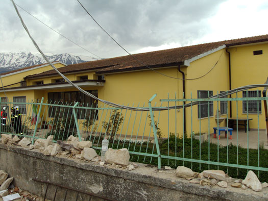
Figure 3. Newly built school in Onna with no evident damage; structures on the opposite side of the street suffered partial or complete collapse. Source: AIR
Other towns surveyed toward the southeast included San Gregorio, Poggio Picenze and Barisciano, respectively located about 8.5, 12 and 16 km from L'Aquila. At Barisciano, the town furthest from L'Aquila that was surveyed, the rate of masonry structures that partially or completely collapsed is significantly less than that observed in Onna. Most vulnerable structures such as that shown in Figure 4 showed slight or no damage.
Figure 4. Three-story mixed masonry building reinforced with cross-ties in Barisciano appears to be intact. Source: AIR
A clear case of the effectiveness of mitigation measures was observed in Barisciano. Figure 5 shows the collapse of an old two-story unreinforced masonry structure. Just next to it, in Figure 6, a building of very similar construction fared well. However, the still-standing house had been reinforced by means of cross-ties (circled in yellow) and a concrete ring beam around the top of the structure just beneath the roof.
Figure 5. Collapse of a two-story masonry house in Barisciano; the corner of the two-story structure at the far left is shown again in Figure 6. Source: AIR
Figure 6. This masonry house just next to the one shown in Figure 5 fared well due to cross-ties (circled) and ring beam (arrow) reinforcements. Source: AIR
West and Northwest of L'Aquila
In contrast to the damage ratios observed toward the southeast of L'Aquila, towns to the northwest but equidistant from L'Aquila experienced significantly less damage. In Coppito, about 5 km from L'Aquila, observed damage levels were similar to those in Barisciano, located some 16 km from L'Aquila. Small commercial establishments were open and operating with relative normality. In Preturo, about 9.0 km from L'Aquila, the observed collapse rate for masonry structures was low.
Damage to Infrastructure
Observed damage to infrastructure included damage to a 0.9 m diameter high-pressure water supply pipeline near the town of Paganica. The rupture of the pipeline caused a landslide and subsequent mud flow (Figure 7); none of the nearby residential structures was affected.
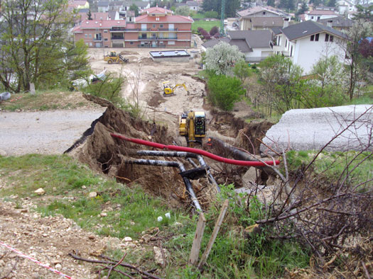
Figure 7. Landslide caused by the rupture of a water supply pipe. Source: AIR
Cracks were observed on the piling of a 30 m long masonry bridge located at the southwest edge of L'Aquila (Figure 8). Another short bridge with damage was observed near the town of Fossa, while a large reinforced concrete bridge in L'Aquila was closed due to the displacement of one of its beams on the supporting pile. Access to this bridge was restricted, so no detailed evaluation was carried out.
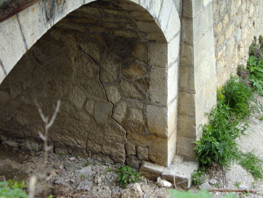
Figure 8. Crack on a stone bridge near L'Aquila. Source: AIR