
Chile Earthquake
Status: Closed
| Type of posting | Posting date(EST): | Summary | Downloads |
|---|---|---|---|
| Update 9 | 3/26/2010 11:45:00 AM |
|
|
| Update 8 | 3/24/2010 8:23:00 AM |
|
|
| Update 7 | 3/19/2010 1:48:00 PM |
|
|
| Update 6 | 3/18/2010 1:30:00 PM |
|
|
| Update 5 | 3/17/2010 8:27:00 AM |
|
|
| Update 4 | 3/15/2010 2:00:00 PM |
|
|
| Update 3 | 3/11/2010 12:00:00 PM |
|
|
| Update 2 | 3/3/2010 12:00:00 PM |
|
|
| Update 1 | 2/27/2010 6:30:00 PM |
|
|
| First Posting | 2/27/2010 5:00:00 AM |
|
Update 8 | Summary
Posting Date: March 24, 2010, 8:23:00 AM
This report is the fifth in a series from AIR’s ongoing damage survey in regions of Chile impacted by an M8.8 earthquake that struck off the country’s coast on February 27. The photos and commentary here offer a glimpse into the kinds of damage patterns caused by this event.
In this report, AIR Principal Engineer Dr. Guillermo Franco, who also served as a member of the team from the Earthquake Engineering Research Institute (EERI), provides commentary from Concepción and Dichato, in the epicentral region. Meanwhile, Senior Engineer Guillermo Leiva remains in Santiago to inspect modern buildings in the city’s financial district, as well as infrastructure.
Major damage discussed in this report includes the tsunami damage that obliterated Dichato and earthquake damage to several buildings now scheduled for demolition in Concepción. Farther from the epicenter, in Santiago, modern buildings performed extremely well, reaffirming the pattern seen throughout the course of the AIR survey: that is, the general performance of recent construction shows that the country’s strict building code significantly mitigated the damage. Despite damage to buildings in Concepcion from this powerful event, the same can be said of the code’s efficacy there.
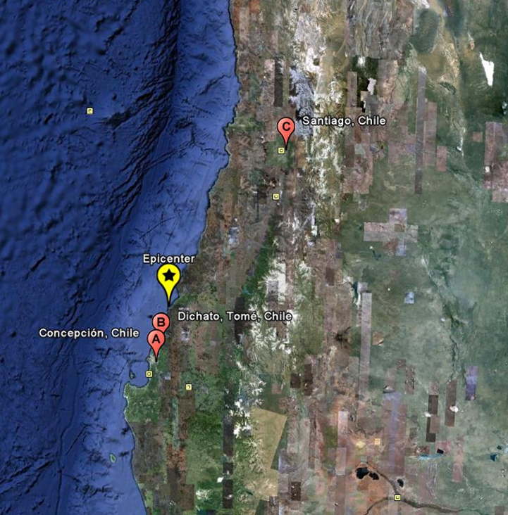
Figure 1: AIR reports from Concepción and Dichato on this leg of the team’s damage survey in Chile. (Source: Google Earth).
On the road to Concepción
En route to Concepción—from the inland town of Chillán about 100 kilometers to the west—several stretches of the road were badly damaged. At the time of the AIR damage survey, traffic was partially impeded as construction teams worked to repair large failures in the embankments. In general, traffic along the main north-south transportation axis—locally known as Ruta 5—is flowing smoothly, with some partial restrictions at several isolated points where traffic in both directions has been detoured into one half of the highway to allow repairs in the other half. These changes have slowed traffic, but the repairs are being made quickly.
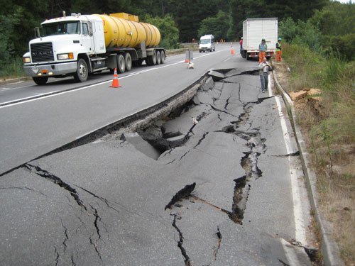
Figure 2. Earthquake damage to a road between Concepción and Chillán. (Source: AIR).
Concepción
Concepción, the second largest city in Chile, is nearly 40 kilometers farther from the epicenter than Constitución, which was covered in the last report. According to the municipality of Concepción, eight buildings in the city are now scheduled for demolition while an additional 48 require an in-depth inspection to assess whether they also will be demolished or whether they can be repaired. In Concepción, one notable example of a building scheduled for certain demolition due to severe damage is the Torre O’Higgins building, a reinforced concrete high-rise of 21 stories. Figure 3 shows the multiple shear failures along its height, as well as the failure of what appears to be a dual system of frames and shear walls.
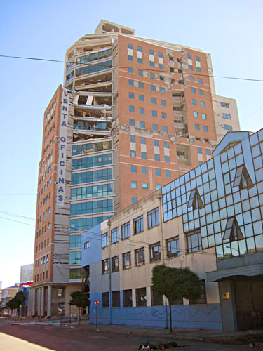
Figure 3. The Torre O’Higgins high-rise suffered severe damages and is scheduled for demolition. (Source: AIR). The Torre O’Higgins building, only completed in 2008, was not fully occupied; the banner on its wall indicated available office space for sale (Figure 4).
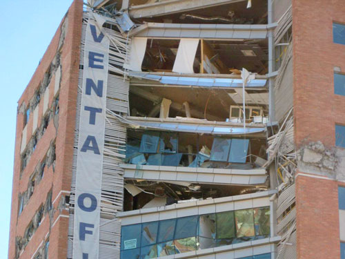
Figure 4. Detail of the Torre O’Higgins building showing multiple shear wall failures. (Source: AIR). The only fully collapsed building in Concepción—a multi-story reinforced concrete residential structure—was on Avenida Arturo Prat (Figure 5). The building crumbled a few minutes after the earthquake struck, killing eleven people.
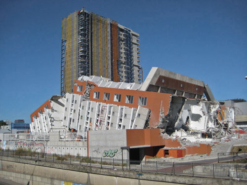
Figure 5. The only fully collapsed building in Concepción. (Source: AIR). Initial observations into what caused the collapse implicate insufficient reinforcement and poor material quality (Figure 6).
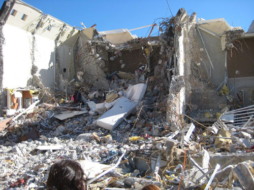
Figure 6. Insufficient reinforcement & poor material quality may have led to collapse (Source: AIR). A set of silos used for wheat storage in Concepción also collapsed during the earthquake. Repair crews were present at the time of the survey to stabilize the structures and to remove the grain.
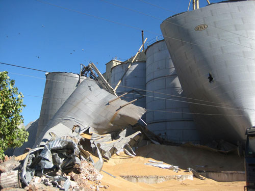
Figure 7. Collapsed wheat silos at an industrial facility in Concepción (Source: AIR). The EERI team visited Concepción and documented damage to two bridges on the Bío-Bío River. One bridge was closed completely. On the other, traffic was limited to a single lane. EERI reports that damage, in both cases, was likely from liquefaction and lateral spreading, along with strong shaking. The EERI team also visited Talcahuano, a port city just 15 kilometers north of Concepción. They observed tsunami damage to the main port control structure—a four story reinforced concrete building. Contents on the first floor (computers, data, electronics, etc.) were ruined, rendering most of the port unusable. Damages from the tsunami were not restricted to physical infrastructure. In Concepción the survey team witnessed how files at the property registry were damaged from submersion under water; these files are now undergoing a process of drying and restoration.

Figure 8. Damage to records at the property registry of Talcahuano. (Source: AIR).
Dichato
The coastal fishing and tourist town of Dichato sits about 30 kilometers north of Concepción. It was among the settlements closest to the massive M8.8 quake, though only minor structural damage to homes there resulted from the temblor, according to residents. The tsunami, however, almost wiped the village off the map. Waves rushed ashore and up river inlets, flooding the central Dichato plains with water 8 meters deep.
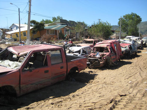
Figure 9. Cleaning crews accumulate destroyed vehicles on a main avenue, Dichato. (Source: AIR). The destruction of boats and fishing apparel has left Dichato and other nearby fishing communities in disarray. Additionally, all 200 commercial small businesses in the village have been closed, and this, combined with contaminated water following the spill of chemical tanks belonging to a local university, has shut down tourism—a normally bustling industry in the town. Indeed the apartment buildings in Figure 10, which under normal circumstances would be full of visitors who come to enjoy Dichato’s bay, survived completely unscathed. But because the local economy has been devastated, they are now closed.
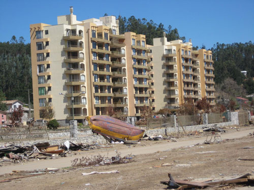
Figure 10. These apartment buildings in Dichato are now deserted despite having survived the earthquake intact. (Source: AIR). Since the tsunami did not reach higher ground, houses in the hills above Dichato’s plains fared better.
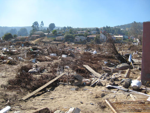
Figure 11. Houses in the hills behind the plains of Dichato were largely intact (Source: AIR). Closer to shore, the home in Figure 12 suffered comparatively less because of its slightly higher local elevation. However, as the photo reveals, its foundations were partially scoured by the tsunami and the support to the structure was partially lost.

Figure 12. This home, on slightly higher ground, only suffered partial scouring. (Source: AIR).
Back in Santiago: Financial District and Infrastructure
Santiago’s financial district—complete with several multinational banks—has experienced explosive growth in the past ten years. It is now characterized by apartment buildings, high-end retail shops and glass towers. Many new buildings in Santiago’s financial district exhibit the preferred construction technique for modern office structures in Chile: a reinforced concrete shear wall core surrounded by large peripheral columns. Elevator shafts are located inside the shear wall core. This technique provides good seismic performance and also allows for open floor plans, which are desirable in office settings.
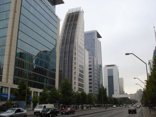
Figure 13. Modern construction in Santiago’s financial district (Source: AIR). The behavior of large expanses of glass on these buildings was reported as satisfactory. The common construction technique is to place a steel embed on the concrete slab, run a steel section from floor to floor attached to the steel embed and, finally, mount the glass panels onto these tracks. Conversations with one glass contractor revealed that there was almost no failure of this system.
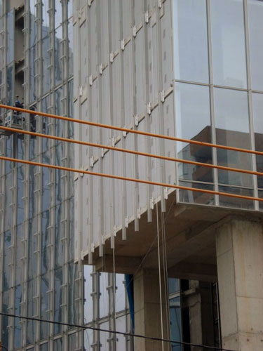
Figure 14. Panels are mounted on steel support structures which run from floor to floor. (Source: AIR). Overall, newly constructed buildings here and in the nearby upscale mall, Parque Arauco, performed extremely well. Almost no structural damage was observed. Conversations with local employees revealed that there had been some contents damage to offices, and many partition walls fell. Mechanical equipment on rooftops was also reported damaged, and a few buildings remained without air conditioning as AIR was conducting its survey. The flagship building in the financial district is the 52-story Titanium, also the tallest skyscraper in Chile. Finished earlier this year, it exhibits the preferred construction type, discussed above. The building design also includes dampers, designed to control the displacement of the building during an earthquake. The dampers are located above the 13th floor and every 3 floors above that. The building performed very well during the event and during subsequent aftershocks. One 30-ton balcony did fail (Figure 15). Workers who were inside during the temblor provided accounts of movement that were not as severe as accounts from people in other high-rise buildings on February 27th.
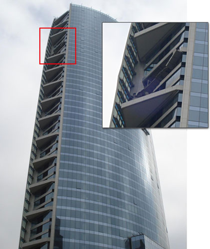
Figure 15. A 30-ton balcony on the Titanium skyscraper fell from the building’s main structure. (Source: AIR). In older construction in the financial district, wall cracking and cladding damage was visible.
Highways and Bridges
The design of highways and bridges in Chile is governed by the “Highway Manual.” Historically, the design scheme in use has been seismic steel rods at the column supports. These rods go through the ends of girders and are anchored underneath slab materials. Transversal concrete beams provide additional support. This technique has performed well in the past and it performed well during the earthquake on February 27th. Unfortunately, not all highways and bridges use the technique described above because the Highway Manual permits alternatives. Other types of bridge supports that did not provide seismic keys to restrict the lateral displacement of the bridge girders proved insufficient to avoid damage. Excessive lateral displacement of the slabs resulted in loss of support and subsequent collapses.
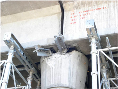
Figure 16. Failure of the support system at an overpass on the Vespucio Norte Highway, in Santiago. (Source: AIR). This report concludes AIR’s damage survey of various regions of Chile impacted by the February 27th earthquake. The AIR earthquake team is analyzing findings from the survey along with the latest available information regarding the parameters of the event itself. Analysis results will be used to fine tune AIR’s modeled loss estimates for this earthquake. ALERT subscribers will be notified when those estimates are available. Ultimately, the wealth of information collected during the course of AIR’s damage surveys and from the numerous interviews conducted with industry experts, local engineers, and governmental and humanitarian organizations will be used to inform future releases of the AIR Earthquake Model for Chile.