Tohoku Earthquake
Status: Closed
Update 4 | Summary
Posting Date: March 24, 2011, 6:30:00 PM
Since the issuance of a preliminary loss estimate just 24 hours after the Tohoku Earthquake, AIR Worldwide researchers assessed newly available ground motion data and analyzed high-resolution satellite imagery to estimate the footprint of the tsunami that followed the earthquake. Based on these detailed analyses, AIR has revised its insured loss estimate for the Mw 9.0 Tohoku Earthquake at between 1.5 trillion JPY and 2.5 trillion JPY. Using today’s exchange rate of 80.9 JPY to the dollar, this translates to a range of between 20 billion USD and 30 billion USD.
By independently estimating the loss due to the tsunami, the combined loss estimate avoids double-counting in the affected areas. The combined insured loss estimate is comprised of insured losses from ground-shaking and fire-following of between 910 billion JPY (11 billion USD) and 1.7 trillion JPY (21 billion USD), and insured losses from tsunami of between 650 billion JPY (8.0 billion USD) and 780 billion JPY (9.7 billion USD).
AIR’s loss estimate includes payouts from the Japan Earthquake Reinsurance Co., Ltd. (JER) and is net of government recoveries. The following table provides a breakdown of AIR estimated residential losses between private non-life insurers and the JER. The table does not include losses to the commercial line of business or mutuals and cooperatives (kyosai).
Table 1: Breakdown of Estimated Insured Residential Losses (JPY Billions)(Source: AIR).

Tsunami Analysis
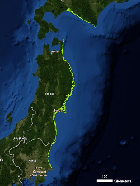
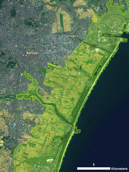
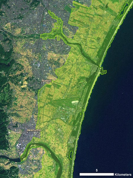
Using high-resolution elevation data and wave height data from the Japan Meteorological Agency (JMA), AIR researchers have created a footprint of the tsunami. Three inundation regions—which span the prefectures of Fukushima, Ibaraki, Miyagi, Iwate, Aomori, and Hokkaido—were generated based on topography and observed wave height, and raster cells below a certain elevation were selected. The modeled footprint was compared to known flooded regions that had been collected from high-resolution maps, aerial photography, and satellite imagery made available from a number of government agencies and private organizations. Based on this data, the modeled footprint was adjusted where necessary to ensure accuracy in the hardest hit regions of Japan. The areas of greatest inland penetration were identified and validated with overland inundation reaching as far as five to six kilometers inland. Thus far, the modeled footprint compares very well with the known flooded regions throughout the entire impacted area. Further validation was undertaken using the Princeton Ocean Model (POM)—a numerical grid point model that is used for many oceanographic applications worldwide. The model has been successfully used to simulate the main features of the tsunami from the Tohoku earthquake. POM output is providing necessary information for areas where higher resolution data from other sources is unavailable. The map shown in Figure 1 illustrates the entire extent of the modeled tsunami footprint. AIR’s modeled footprint extends from the southeastern coast of Ibaraki Prefecture to the southwestern coast of Hokkaido Prefecture.
Figure 1: AIR's modeled tsunami footprint for the tsunami following the March 11 Tohoku Earthquake. (Source: AIR).

Figure 2: AIR's modeled inland penetration of the tsunami at Sendai.(Source: AIR).

Figure 3: AIR's modeled inland penetration of the tsunami at Natori.(Source: AIR).
Updated ground motion analysis
The website of Japan's national seismic network, the Kyoshin Network, or K-NET, remained offline for nearly a week following the earthquake; ground motion observations were unavailable for that entire period. Since that time, however, ground motion recordings have become available and AIR seismologists have constructed a large number of stochastic ground motion scenarios consistent with the recorded ground motion data at the K-NET and KIK-NET stations. As of today, March 24, the National Research Institute for Earth Science and Disaster Prevention (NIED) has released 381 ground motion data sets recorded by the Japan K-NET and KIK-NET networks. It should be noted that although the ground motions of the Tohoku earthquake were recorded by a number of stations, the large distances between some stations means that large uncertainties exist for ground motion at sites far away from recording stations. AIR used the best estimates of the earthquake source parameters and the regional ground motion prediction equations to calculate a regional footprint of the ground motions for reference site conditions. Using the general concept of ground motion spatial correlation effects and the regional site condition information, sets of random residual fields were created and applied to the median ground motions to simulate sets of stochastically correlated ground motion fields. AIR has done hundreds of such simulations to ensure that we have robust distributions of losses, out of which we have selected five scenarios to capture the uncertainty in the loss estimates. AIR used the K-NET and KIK-NET ground motion data to constrain the simulated ground motions within the defined distance of influence for each station. Because the spatial distribution of slip on a rupture area can impact the intensity of the ground motions in a complex way—a way which cannot be estimated using the regional ground motion prediction equations—AIR also used the spatial distribution of slip to formulate the possible effects of the rupture complexity on earthquake ground motions. A number of institutes have constructed the most likely slip distribution for the earthquake using long period ground motions. Using this information about the most likely slip distribution, AIR developed procedures to account for the slip distribution complexities on regional ground motions based on regional ground motion prediction equations.Update on Reported Damages as of March 24
Nearly two weeks after the March 11 Tohoku earthquake and tsunami, efforts to avert a nuclear reactor meltdown at the six-reactor Fukushima power plant in Fukushima prefecture remain at the forefront of recovery efforts. Nearly two dozen workers have been injured in attempts to stop radiation leaks at the tsunami-damaged plant. Earlier this week, repairmen were forced to cease their efforts after black smoke suddenly rose from two reactors. Since that time, however, engineers have resumed repairs at reactor number 3, considered the most important reactor to stabilize. They have also managed to attach power cables to all six reactors at the complex, two of which are now considered safe. The other four reactor sites remain volatile, giving off steam and smoke intermittently. The repairmen at the complex have also managed to restart a water pump, which will be used to help reverse the overheating that caused the nuclear crisis at the Fukushima plant. A Japanese nuclear expert said the main risk now is from continued radiation leaks, and that the risk of a nuclear meltdown is low. Concerns about radiation extend outside of Fukishima prefecture into the capital, where residents worry about hazardous substances in water, vegetables and milk. Until Wednesday, officials reported that levels of radioactive matter found in Tokyo tap water had been small. Today, however, reports indicate that radiation has made tap water unsafe for infants; the same is true adjacent to the capital in Chiba prefecture, where radioactive substances have been detected in the water purification system—again at levels unsafe for infants. Some water samples contained twice the legal limit of radioactive iodine, a hazardous substance. In a research facility in Tokyo, a specific type of leafy vegetable was reportedly exhibiting levels of radioactive cesium 1.8 times higher than normal. In Japan’s northeast, meanwhile, people have been advised not to drink tap water; levels of radioactive iodine—which can cause thyroid cancer—are elevated there. And outside Japan’s borders, radiation is a concern. Singapore, Australia, Hong Kong and the United States have stopped importing food and milk from the area around the damaged nuclear power plant. Additionally, some ships are avoiding Tokyo port—concerned that members of their crews could be exposed to radioactive substances. A ship that arrived in Russia after delivering plywood in Japan and passing near the quake-damaged nuclear power plant was reportedly carrying radiation levels three times the norm. On Monday, Toyota Motor Corp—which halted its supply chain for two weeks—will resume production of three hybrid models. It will restart both auto assembly operations and parts manufacturing but it will only be able to maintain production if it receives enough parts every day after the start. To this end, Toyota has sent engineers to suppliers of car parts in locations of Japan impacted by the quake in order to help them restart production at their own facilities. Efforts are being made to repair infrastructure. The Tohoku Expressway, which connects Tokyo and the northeast earthquake and tsunami damaged area, has reopened. Meanwhile, in terms of lives lost, the impact of the earthquake and tsunami has been huge. As of Thursday, March 24, Japan's Fire and Disaster Management Agency (FDMA), which reports only cases that have been verified and whose numbers are therefore still conservative, has reported more than 9,000 deaths and more than 13,000 people missing. Search and rescue operations continue. Roughly 760,000 households spanning 10 prefectures including Fukushima, Miyagi, Iawte and Ibaraki are still waiting for water supplies to be restored. In Miyagi and Fukushima Prefectures, the government has begun constructing temporary shelters, prioritizing families with elderly, handicapped, pregnant women and women with babies. The government is encouraging people to move to shelters in unaffected prefectures. So far, about 13 percent of evacuees, or nearly 30,000 people, have relocated to 437 municipalities in 43 prefectures. Meanwhile, the number of people living in shelters has dropped from nearly 350,000 as of Monday to 261,000. In terms of international relief, over 45 countries and aid organizations from around the globe have donated a total of 145 million USD, and the Japanese Red Cross Society has received more than 249 million USD. Note that AIR's industry insured loss estimates reflect:- Insured physical damage to property (residential; commercial/industrial; mutuals and cooperatives [kyosai]), both structures and their contents resulting from shake, fire following and tsunami.
- Direct business interruption losses (It should be noted that while the AIR IED does not include BI exposures, clients can model BI losses in CLASIC/2);
- Losses from non-modeled perils, including landslide;
- Losses to automobiles;
- Losses to uninsured properties;
- Losses to land;
- Losses to casualty and life lines;
- Losses to infrastructure;
- Indirect business interruption losses;
- Loss adjustment expenses;
- Demand surge—the increase in costs of materials, services, and labor due to increased demand following a catastrophic event. Demand surge can be applied by AIR software users who want to account for this variable.