
Iran-Pakistan Earthquake
Status: Closed
| Type of posting | Posting date(EST): | Summary | Downloads |
|---|---|---|---|
| First Posting | 4/16/2013 1:15:00 PM |
|
First Posting | Summary
Posting Date: April 16, 2013, 1:15:00 PM
Just after 3:00 PM local time (10:44 UTC) on April 16, a powerful M7.8 earthquake struck a sparsely populated area of southeastern Iran about 50 kilometers (30 miles) from the country’s border with Pakistan. According to the United States Geological Survey (USGS), the earthquake struck at a depth of 82 kilometers (51 miles). The Iranian Seismological Center characterized the quake as the worst to strike the country in 40 years. It was felt as far away as New Delhi, India, and the Gulf States.
Reported Damage and Disruption
In Saravan (population 60,000), the largest Iranian city close to the epicenter of the earthquake, a state of emergency was declared. A Saravan official reported that about six or seven people had been injured and that buildings were damaged in villages near Saravan and near Khash, a smaller town closer to the epicenter. In Zahedan (population 550,000), northwest of the epicenter, people reportedly poured into the streets when the shaking began. In Pakistan, officials reported that at least eight people were killed and 20 injured in the town of Mashkeel in the province of Baluchistan, which borders the Iranian province where the earthquake ruptured. The head of a health center in Mashkeel said that several hundred houses in the town had collapsed. In the Baluchi district of Panjgur, three women and two children were reported to have died when their mud house collapsed. In Karachi, about 700 km (435 miles) to the south and east, television news footage showed buildings shaking and people running from them in panic. Other reports state that the walls of residential buildings and government offices developed cracks from the shaking. The earthquake caused tall buildings to shake and sway as far away as India’s capital, New Delhi (1,500 km/950 miles distant), also sending people running into the streets. Buildings in Qatar and Dubai were also reported to have been evacuated because of shaking. Reports from the stricken area concerning deaths and injuries have conflicted. One Iranian official told news agencies that there were no fatalities, while another told Reuters, quoting unconfirmed reports, that 40 people had died and that he expected more fatalities. Iranian television also reported that at least 40 people had been killed, but gave no other specific details on the extent of damage or casualties. Iran’s Red Crescent aid agency described the area as being populated by small villages scattered over desolate hills and valleys and that the earthquake was a “complicated emergency situation.”Regional Seismicity
Iran is situated on major geological faultlines, and earthquakes are not uncommon in the country. Only one week ago, on April 9, an M6.3 quake struck close to Iran’s only nuclear power station—on the opposite (western) side of the country. Four major tectonic plates (the Arabian, Eurasian, Indian, and African plates) and one smaller tectonic block (Anatolia) comprise the source of the seismicity and tectonics in the Middle East and its immediate surrounding regions. In southern Iran, seismic activity is dominated by the collisions of the Arabian and Indian plates with the Eurasian plate. At the longitude of today’s event, the Arabian plate is converging toward the north-northeast at a rate of approximately 37 millimeters a year with respect to the Eurasian plate. The M7.8 rupture today occurred as a result of normal faulting at an intermediate depth—as stated earlier, about 82 kilometers (51 miles)—in the Arabian plate lithosphere (the uppermost region of the earth’s crust). The Arabian plate is subducting (pushing beneath) the Eurasian plate at the Makran coast of Pakistan and Iran south of today’s event. The subducting Arabian plate is known to be seismically active to depths of about 160 km. The frequency of moderate and large earthquakes within the Arabian plate is not high compared to similar activity in other subducted plates worldwide, but several earthquakes have occurred within this slab in the region of today's event during the past 40 years, including a magnitude 6.7 shock 50 km to the south in 1983. In January of 2011, an M7.2 earthquake occurred approximately 200 km to the east (in Pakistan), where the tectonic environment is similar to that of today’s event. AIR continues to monitor this situation and will provide updates if warranted by events. Insurance losses from this event are expected to be minimal.
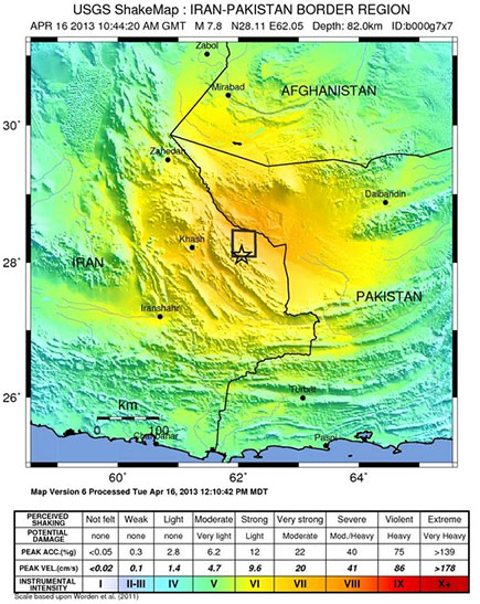
Figure 1: 2013 Iran-Pakistan Earthquake Shake Map (Source: USGS).