
Philippines Earthquake (2013)
Status: Closed
| Type of posting | Posting date(EST): | Summary | Downloads |
|---|---|---|---|
| First Posting | 10/16/2013 6:00:00 AM |
|
First Posting | Summary
Posting Date: October 16, 2013, 6:00:00 AM
According to the United States Geological Survey (USGS), at 8:12:32 UTC Tuesday morning, a magnitude 7.1 earthquake struck the central Philippines. The epicenter was located about 619 km south- southeast of Manila near the city of Catigbian on Bohol Island. The quake struck at a depth of 20 km and caused widespread damage. The death toll currently stands at 97.
Reported Impact
The early morning timing of Tuesday’s temblor combined with the closure of schools and offices due to a national holiday likely mitigated the quake’s deadly impact. However, there are still many reports of damage, injuries, and loss of life throughout the impacted region. Cebu province, home to more than 2.6 million people, and nearby Bohol province, with a population of 1.2 million people apparently sustained the worst damage.
In Cebu City, a sprawling shopping mall, prominent hospital, and busy public market were all among the damaged buildings in this thriving commercial center. Five fatalities and several injuries also resulted from stampedes—one of which occurred while people were waiting in line to receive cash assistance from a governmental program. There were also fatalities when the roof of a fish market fell. Many of Cebu’s historic churches, which date from the Spanish colonial period, were also damaged. One of these churches, the 16th-century Basilica of the Holy Child in Cebu—the country’s oldest—lost its bell tower. There was also damage at Cebu’s international airport; however, passenger flights had resumed by Tuesday afternoon.
On Bohol Island, there are extensive reports of collapsed buildings, cracked roads, and fallen bridges. In addition, a main pier was damaged in Bohol’s provincial capital of Tagbilaran. In the municipality of Loon, the Congressman Castillo Memorial Hospital partially collapsed trapping an unknown number of patients inside. Soldiers were called back from holiday furlough to assist with this and other rescue efforts. Widespread power outages complicated these efforts as evening approached.
By Tuesday evening, authorities had set up tents for those displaced by the quake. Government officials declared a state of calamity for both the islands of Cebu and Bohol, authorizing additional national government assistance for those areas. Officials also warned local residents not to enter major buildings until their structural integrity was confirmed. Both private and public schools are closed on Wednesday so that officials can check on those buildings.
Regional Seismicity
The Philippine Mobile Belt (PMB) is a region of rapid deformation and intense volcanism, where multiple tectonic blocks are confined between two opposing subduction zone systems produced by the convergence of the Philippine Sea Plate and the Sundaland (part of Eurasia) Plate. Subduction occurs along the west-verging Philippine Trench-East Luzon Trough and the east-verging Manila-Negros-Cotabato Trench. The entire PMB is a region of intense earthquakes due to these different subduction zones, and also due to internal strike-slip faulting occurring mainly along the Philippine Fault System and its numerous splays, which traverses the entire Philippine archipelago from South to North.
Tuesday’s earthquake occurred in the South-Central Philippines, a region which absorbs the east-west compression due to the Negros Trench. It is bounded on the east by crustal faults: the Philippine Fault, on the north by the Verde Passage-Sibuyan Sea Fault System, on the west by the Negros Trench, and on the northwest by the Mindoro-Palawan collision zone (situated in between the Manila Trench and Negros Trench). Further east of the Philippine Fault, westward subduction along the Philippine Trench occurs along this region. The immediate region is pervaded by shallow strike-slip earthquakes on the east due to the Philippine Fault, and thrust earthquakes on the west, due to the Negros Trench and related thrust faults. Further east, strong thrust earthquakes due to subduction along the Philippine Trench are also common.
This particular M7.1 earthquake is characterized by northwest-southeast thrust motion, originating from a shallow crustal source at 20 km deep, which may be associated with thrust faults related to the Negros Trench. The last major earthquake to occur in this immediate area was an M6.7 event occurring in Negros Island on February 6, 2012. This event also struck at a depth of 20 km and was associated with a nearly similar thrust mechanism orientation. In 1948, an M8.1 earthquake occurred west of this area, along the shallow subduction interface of the Negros Trench. For the entire PMB, among the most recent destructive earthquakes include the M7.8 1990 Luzon Earthquake, a shallow strike-slip event which occurred along a segment of the Philippine Fault, approximately 700 km north northwest of this region. In 1976, a destructive M8.0 tsunamigenic earthquake occurred along the Cotabato Trench, about 370 km south of the region. The latter two events caused thousands of fatalities (>1,600 and >5,000 respectively) and extensive property damage.
Exposure at Risk
In the Cebu and Bohol areas, as in most of the Philippines, the prevalent construction types are generally unreinforced masonry, reinforced masonry, reinforced concrete, and wood. Reinforced masonry performs much better than unreinforced masonry under small to moderate amounts of shaking. However, they are both prone to collapse under strong shaking. Many reinforced concrete buildings in the region are also very vulnerable due to not being built to standard because of a lack of code enforcement and code compliance practitioners. The construction quality in some areas may also be adversely affected by a conflict of interest in which the designer ends up also serving as the builder.
Among the prevalent building types in the region, those constructed without engineering consideration are most vulnerable. In the urban cities such as Cebu, buildings are constructed relatively well, but in coastal areas there are many non-engineered and poorly constructed buildings.
Inadequate foundation in addition to poor construction practices have also resulted in building failures in the region. For instance, a magnitude 7.9 earthquake centered in the Celebes Sea, between the Islands of Mindanao and Borneo produced extensive damage to buildings constructed on alluvial deposits without adequate pile support. The seismic code in the Philippines has since been updated in 2001. However, the significant damage caused by three moderate earthquakes since 2001 (as many as 800 buildings in the M6.8 Palimbang earthquake in 2002) is evidence that the codes have only begun to affect construction practices.
The AIR earthquake team is continuing to monitor the situation and will provide updates if warranted.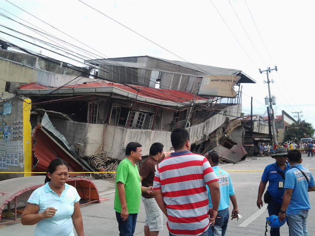
Damaged buildings in Bargay Mambaling section of Cebu City (Source: Justin K. Vestil of SunStar)