
M6.0 Napa California Earthquake
Status: Closed
| Type of posting | Posting date(EST): | Summary | Downloads |
|---|---|---|---|
| Update 1 | 8/29/2014 11:59:00 AM |
|
|
| First Posting | 8/25/2014 6:00:00 AM |
|
First Posting | Summary
Posting Date: August 25, 2014, 6:00:00 AM
At 10:20 UTC (3:20 a.m. local time), August 24, a magnitude 6.0 earthquake struck near Napa, California, about 50 miles west-southwest of Sacramento, the state capital. According to the USGS, who revised their initial magnitude estimate down from 6.1, the quake occurred at a depth of just 6.7 miles, making this a shallow event. Shaking, which lasted about 30 seconds, was felt in San Francisco, some 40 miles from the epicenter. It is the strongest earthquake to hit the San Francisco Bay area since the 1989 Loma Prieta earthquake, which registered a magnitude 6.9.
Photos available on Twitter show cabinet doors and drawers thrown open in homes, windows shattered, and goods thrown from store shelves. In Napa, a center of the California wine industry, one winery posted a photo of bottles having been thrown to the floor.

Damage at Silver Oak Winery in Napa. pic.twitter.com/uSfHX2WzBk
There are at least two reports of structural damage to unreinforced masonry (URM) buildings in Napa’s historic downtown; toppled brick parapets are more widespread. Pacific Gas and Electric Company is reporting power outages to about 10,000 households in Napa and surrounding towns. Gas leaks have also been reported and a fire broke out in a nearby mobile home park. The California Highway Patrol is checking bridges but has yet to report any structural damage. Buckled roadways, however, have been reported in and around Napa. The Bay Area Rapid Transit (BART) has not reported any damage. No serious injuries have been reported.
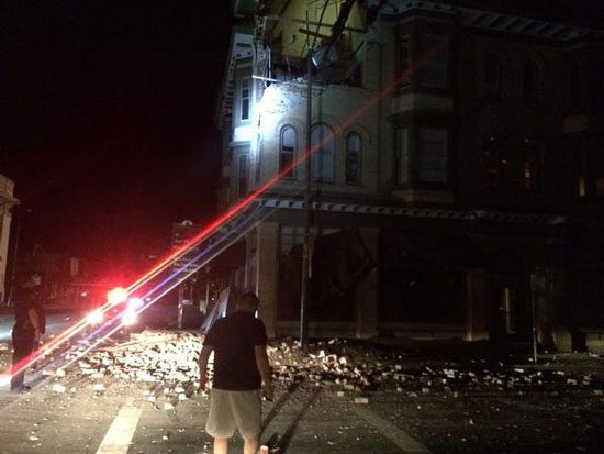
Structural Damage to URM Building in Napa. pic.twitter.com/8ayRfhgVeZ
Today’s earthquake had a strike-slip mechanism with an almost vertical dipping angle. The epicentral location is very close to the West Napa fault, which lies between two major traces of the San Andreas fault system—the Hayward-Rodgers Creek fault zone to the west and the Calaveras-Concord Green fault zone to the east. In 2000, a magnitude 5.0 earthquake occurred about 20 miles northwest of today’s event.
It is in the very early aftermath of this earthquake and reports are only just beginning to come in. The AIR earthquake team is monitoring the situation closely and collecting the available ground motion data. AIR will provide updates as necessary.