Kumamoto Earthquake
Status: Closed
| Type of posting | Posting date(EST): | Summary | Downloads |
|---|---|---|---|
| Update 2 | 4/20/2016 3:00:00 PM |
|
|
| Update 1 | 4/15/2016 2:00:00 PM |
|
|
| First Posting | 4/14/2016 2:30:00 PM |
|
First Posting | Summary
Posting Date: April 14, 2016, 2:30:00 PM
A strong and shallow earthquake occurred on Kyushu, the most southwesterly of Japan’s four main islands, at 9:26 p.m. local time (12:26 UTC) on April 14. The temblor was centered near the town of Mashiki in Kumamoto Prefecture, about 1,300 km (800 miles) southwest of Tokyo. The Japanese government issued a high-level alert in the southern province and alerted disaster management teams. Damage to buildings and some casualties are being reported. The earthquake has been followed by a series of aftershocks, but there is no risk of a tsunami.
The United States Geological Survey (USGS) currently estimates the intensity of the initial temblor at M6.2, and the Japan Meteorological Agency (JMA) currently estimates it at M6.4. The depth has been initially estimated by the USGS as 23.3 km (14.4 miles) and by the JMA as 10 km (6.2 miles). Shaking started modestly, grew more violent, and lasted about 30 seconds.
Kumamoto Prefecture is situated in the center of Kyushu and contains 14 cities. More than 8 million people live within 100 km (62 miles) of the epicenter of this earthquake.

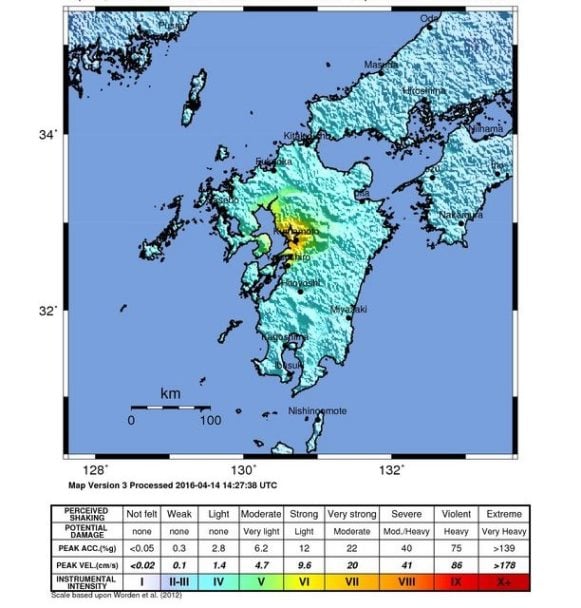
ShakeMap for the M6.2 earthquake that struck Kyushu on April 14, 2016 (UTC). (Source: USGS)
Tectonic Background
Kyushu lies on the overriding plate above the Philippine subducting plate to the west of the Nankai subduction zone. The region is exposed to subduction interface, intra-slab, and shallow crustal earthquakes. During the last 50 years, the region within 150 km of the present earthquake experienced about 55 M5.0 and larger earthquakes, with a few M7.0 or larger interface earthquakes. However, historically there has not been any record of large M8.0 subduction interface earthquakes in this area.
Geologically, a large right-lateral shear zone running through the central part of Kyushu divides the island. This shear zone is an extension of the median tectonic line (MTL) that originates at Honshu Island and transects the island of Shikoku. The MTL is the largest tectonic line in southwestern Japan. Most seismotectonic studies and data from past earthquakes in this area indicate earthquakes with right-lateral strike-slip and extensional rupture mechanisms. Kyushu Island hosts significant volcanic activity. The volcanic front runs through the central part of the island from north to south, and a group of volcanoes is also located on a line obliquely crossing the volcanic front.
A recent detailed regional stress analysis (Matsumuto et al., 2015) using faulting mechanisms of past earthquakes indicates a principal stress distribution with the NE-SW shear zone, consistent with the right-lateral faulting behaviors and extension field with normal faulting in the central part of Kyushu, northeast of the location of the present earthquake. The extension feature is attributed to the Ryukyu Trench, located in southeastern Kyushu, rolling back and inducing regional seafloor spreading.
Reported Impacts
Damage and casualties from the area are now being reported. In Mashiki several houses have been flattened, and occupants may be trapped inside; several fires have been noted. Roads have been damaged, and at least 10 buildings have collapsed in Kumamoto City, the capital of the prefecture. Elsewhere, large cracks have been reported in several structures. Walls of some houses have collapsed in the city of Ueki, and part of a city hall ceiling fell. Gas and power outages have occurred in areas close to the epicenter.
The Sanyo Shinkansen “bullet train” service briefly lost power and has been suspended on Kyushu as a precaution. The Kyushu Electric Company reports no issues at the Genkai or Sendai nuclear power plants on Kyushu or at the shut-down Ikata plant on nearby Shikoku.
At least three people are dead and more than 45, some of whom are in serious condition, are being treated in hospitals. Some 600 people have been evacuated from their homes. No immediate damage was reported in neighboring Miyazaki prefecture.
Exposure at Risk
Buildings in Japan are predominantly wood, steel, or steel-reinforced concrete. Residential exposures are dominated by single family homes, of which nearly 90% are of wood construction. Apartment complexes in Japan are usually of steel or steel-reinforced concrete construction; only about 24% are of wood construction.
Among commercial buildings, wood is even rarer and is only used for about 12% of the building stock with most of them being steel or steel-reinforced concrete. The small industrial building stock is primarily of steel or light metal with about 20% made of concrete.
Older buildings in Japan are typically quite vulnerable to shake damage, as many were built under the misguided view that a higher degree of stiffness prevents building failure. As research and construction techniques have improved, building codes have been updated to increase safety.
Insurance Impact
Japan experiences around 20% of the world's most powerful earthquakes, but its rigid building codes and their strict enforcement mean that powerful tremors frequently do little damage, at least to engineered structures. However, as initial reports of this event confirm, vulnerable structures still exist.
The USGS issued a green alert for shaking-related fatalities, indicating a low likelihood of casualties and damage. Because some damage is possible but the impact relatively localized, a higher yellow alert level was issued for economic losses.