Kumamoto Earthquake
Status: Closed
| Type of posting | Posting date(EST): | Summary | Downloads |
|---|---|---|---|
| Update 2 | 4/20/2016 3:00:00 PM |
|
|
| Update 1 | 4/15/2016 2:00:00 PM |
|
|
| First Posting | 4/14/2016 2:30:00 PM |
|
Update 2 | Summary
Posting Date: April 20, 2016, 3:00:00 PM
AIR Worldwide estimates that insured losses to properties from the April 16 M7.0 earthquake that struck Kumamoto Prefecture on Japan’s Kyushu Island will be between JPY 180 billion (USD 1.7 billion) and JPY 320 billion (USD 2.9 billion).
Kyushu Island continues to take stock of the casualties and widespread losses from two shallow and major earthquakes that struck southwestern Japan last week.
Fifty-eight people are reported to have been killed, and more than 900 have been injured. The Japan Fire and Disaster Management Agency (FDMA) estimates that more than 3,900 residences and 120 non-residential buildings were damaged or destroyed, a number of mudslides resulted, and 14 fires were attributed to the temblors. Other impacts from the two quakes include power and water outages; damage to highways, rail lines, bridges, and other infrastructure; short-term cancellation of some airline and train service; and significant supply-chain and production interruption for regional industries.
The first earthquake, a foreshock, estimated at M6.2 by the U.S. Geological Survey (USGS), occurred April 14, at 9:26 p.m. local time (12:26 UTC), at an estimated depth of 23.3 kilometers (14.4 miles). Centered near the town of Mashiki in Kumamoto Prefecture, about 1,300 km (800 miles) southwest of Tokyo, the earthquake was followed by seven additional foreshocks (one an M6.0 event), within just three hours after the initial quake.
The mainshock, estimated at M7.0 by USGS, struck April 16 at 1:25 a.m. local time (April 15 at 16:25 UTC)—a little more than 24 hours after the initial M6.2 foreshock—at a depth estimated at 10 kilometers (6.2 miles). According to the USGS, this M7.0 event, also centered in the Kumamoto Prefecture, was 15.8 times stronger in its energy release than the M6.2 foreshock. The Japan Meteorological Agency issued tsunami advisories for both the Ariake Sea and Yatsushiro Sea but then lifted them less than an hour later.
Kumamoto Prefecture is situated in the center of Kyushu and contains 14 cities; more than 8 million people live within 100 km (62 miles) of the epicenter of this earthquake.
A video of the largest landslide produced by the Geospatial Information Authority of Japan (GSI) is available at this link.
Impacts to Residential Buildings and Public Facilities
After the April 14 M6.2 foreshock, power was cut in many areas, gas supplies were turned off by Saibu Gas after gas leaks were reported, and tens of thousands of households were without running water. In the initial hours after that quake, many buildings were assessed to have structural damage that made them uninhabitable, an estimated 20 buildings collapsed, and several fires were reported. Damage from the April 16 M7.0 mainshock, however, was far more significant.
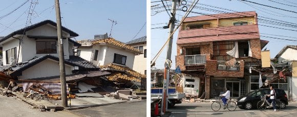
Almost all of the residential building damage occurred in Kumamoto Prefecture, although Fukuoka, Oita, and Miyazaki prefectures also have experienced some damage. FDMA estimates that 1,453 residential buildings have been totally damaged (all in Kumamoto Prefecture), 1,314 half damaged, and 1,205 partially damaged. (The categories of reported damage correspond to the step-policies common in Japan.) FDMA also reported that 122 non-residential buildings were damaged from the two quakes, 63 public buildings, and 59 “other” buildings. As with residential damage, almost all occurred in Kumamoto Prefecture. In addition, Kumamoto Castle, a national treasure and popular tourist attraction, was heavily damaged.

Damage to residential buildings in Kumamoto. (Source: AIR)
Commercial/Industrial Impacts
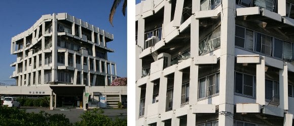
Kumamoto Prefecture—located in the heart of Kyushu Island—is home to roughly 25% of Japan’s semiconductor production, including some of the country’s leading manufacturers. In addition to its vast electronics industry, Kyushu Island also boasts many manufacturing facilities, including automotive, ship, steel, and tire, as well as refinery operations. Since the earthquakes, a number of plants have reduced or stopped production, and some supply-chain interruptions are expected.

Damage to an engineered commercial building in Kumamoto. (Source: AIR)
Regional Seismicity
Kyushu Island lies on the overriding plate above the Philippine subducting plate to the west of the Nankai subduction zone. The region is exposed to subduction interface, intraslab, and shallow crustal earthquakes. During the last 50 years, the region within 150 km (93 miles) of the April 16 earthquake experienced about 55 M5.0 and larger earthquakes, with a few M7.0 or larger interface earthquakes. However, historically there has not been any record of large M8.0 subduction interface earthquakes in this area.
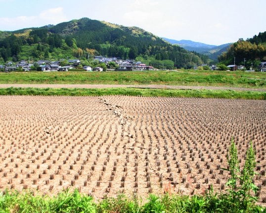
Geologically, a large right-lateral shear zone running through the central part of Kyushu divides the island. This shear zone is an extension of the median tectonic line (MTL) that originates at Honshu Island and transects Shikoku Island. The MTL is the largest tectonic line in southwestern Japan. Most seismotectonic studies and data from past earthquakes in this area indicate earthquakes with right-lateral strike-slip and extensional rupture mechanisms. Kyushu Island hosts significant volcanic activity. The volcanic front runs through the central part of the island from north to south, and a group of volcanoes is also located on a line obliquely crossing the volcanic front.
A recent detailed regional stress analysis using faulting mechanisms of past earthquakes indicates a principal stress distribution with the NE-SW shear zone, consistent with the right-lateral faulting behaviors and extension field with normal faulting in the central part of Kyushu, northeast of the location of the present earthquake. The extension feature is attributed to the Ryukyu Trench, located in southeastern Kyushu, rolling back and inducing regional seafloor spreading.

Surficial expression of the fault line in Kumamoto Prefecture. (Source: AIR)
Loss Estimates
AIR Worldwide estimates that insured losses to properties from the April 16 M7.0 earthquake that struck Kumamoto Prefecture on Japan’s Kyushu Island will be between JPY 180 billion (USD 1.7 billion) and JPY 320 billion (USD 2.9 billion).
AIR’s loss estimates are net of government recoveries but are prior to the application of the JER structure. They explicitly capture damage from ground shaking, liquefaction, and fire following. Losses are dominated by shake damage in AIR’s scenarios, with a very small contribution from liquefaction and fire-following. Note that AIR’s estimates are based on assumptions about take-up rates in Japan (the percentage of properties actually insured against the earthquake peril), which are uncertain. The range in loss estimates also reflects uncertainty in the slip distribution on the fault plane, modeled ground motion, and damage estimation. Note, too, that AIR’s modeled loss estimates reflect damage resulting from the April 16 M7.0 mainshock. However, the range of uncertainty captured by the simulated scenarios is expected to capture the marginal impact on losses from the foreshocks, including the M6.2 event that occurred on April 14. The assumed exchange rate is 1 JPY = 0.009193712 USD.
ALERTTM subscribers can download scenarios for the event, in addition to similar stochastic event IDs and a Touchstone-ready shapefile of the estimated ground motion (peak ground acceleration) for the median scenario.
AIR’s insured loss estimates reflect:
- Insured physical damage to onshore property (residential, commercial/industrial, mutual), both structures and their contents, and from ground shaking, fire-following, and liquefaction
The loss estimates do not reflect:
- Losses to uninsured properties
- Losses to land
- Losses to infrastructure
- Losses to automobiles
- Business interruption losses, both direct and indirect
- Workers compensation losses
- Losses to Civil Engineering (Railway) Risks, Marine Cargo and Marine Hull Risks, Aviation
- Risks, Transit Warehouse Risks, Movable All Risk, and Personal Accident Risks
- Loss adjustment expenses
- Losses from non-modeled perils, such as landslide
- Demand surge—the increase in costs of materials, services, and labor due to increased demand following a catastrophic event (Demand surge can be applied by AIR software users who want to account for this variable.)