M7.8 New Zealand South Island Earthquake
Status: Closed
| Type of posting | Posting date(EST): | Summary | Downloads |
|---|---|---|---|
| Update 2 | 11/17/2016 12:15:00 PM |
|
|
| Update 1 | 11/15/2016 2:10:00 AM |
|
|
| First Posting | 11/13/2016 1:45:00 PM |
|
First Posting | Summary
Posting Date: November 13, 2016, 1:45:00 PM
A powerful magnitude earthquake struck a relatively sparsely populated area of New Zealand’s South Island just after midnight, local time, about 93 km north-northeast of Christchurch, a city still recovering from a pair of earthquakes in late 2010 and early 2011. New Zealand’s GeoNet has estimated the magnitude at 7.5. The U.S. Geological Survey (USGS) initially estimated the magnitude at 7.4 but later revised it to 7.8.
Shaking was felt as far away as the nation’s capital, Wellington, at the southern end of North Island and 215 km (133 miles) from the epicenter. Photos in Wellington show broken shop windows and residents gathered on the streets after fleeing their homes.
Communications with towns closer to the epicenter have been difficult, but aerial images show a tunnel along the coastal highway to Kaikoura covered by a landslide. Other photos show large cracks in roads, goods knocked off shelves, and broken glass. Images posted by homeowners on Twitter show some structural damage and considerable damage to contents.
Schools and businesses throughout the country are closed Monday so that buildings can be assessed for safety. Two people are reported to have died in the quake, but officials say that the number may rise.
Seismic design codes in New Zealand have set stringent requirements for new buildings, and many cities have initiated a comprehensive policy to identify vulnerable pre-1976 buildings with the goal of retrofitting them. Non-engineered buildings such as unreinforced masonry structures are the most vulnerable types in this region.
New Zealand’s Earthquake Commission (EQC) covers the first NZD100,000 of damage to residential properties and land, and up to NZD 20,000 for damaged contents. Private insurers cover damage beyond that level. Commercial property damage is not covered by the EQC; however, because the earthquake occurred in a sparsely populated area of New Zealand, the total insured value of commercial and industrial exposure is estimated to be relatively low.
Regional Seismicity
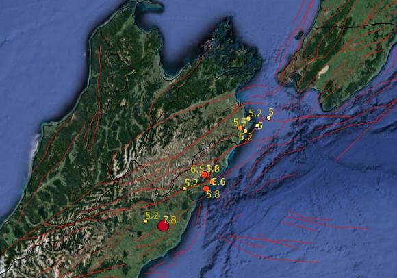
Although today’s event had a strike-slip component, it was primarily a thrust earthquake, suggesting that it might be a subduction-type earthquake, although the dip angle of 38 degrees is larger than the typical subduction zone event. Figure 1 shows the locations of the mainshock, its aftershocks, and the known faults in this region. It appears that all large aftershocks have occurred to the north of the main shock.
This earthquake happened in a seismically complex area where the Hikurangi subduction zone is transitioned into the Alpine crustal fault through the Marlborough fault system.
 Figure 1. Location of the M7.8 mainshock and aftershocks, along with the locations of the known faults in the region. (Source: USGS and AIR)
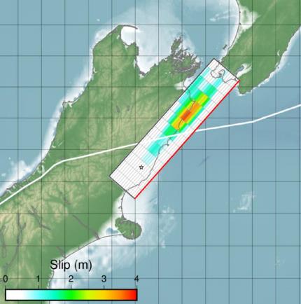
Figure 2 shows the slip distribution as estimated by the USGS. Note that, in line with the spatial distribution of the aftershocks, the bulk of slip release occurred to the north of the epicenter.

Figure 2. Slip distribution as estimated by the USGS. (Source: USGS)