M8.1 Chiapas Mexico Earthquake
Status: Closed
| Type of posting | Posting date(EST): | Summary | Downloads |
|---|---|---|---|
| Update 1 | 9/19/2017 11:30:00 AM |
|
|
| First Posting | 9/8/2017 9:00:00 AM |
|
First Posting | Summary
Posting Date: September 8, 2017, 9:00:00 AM
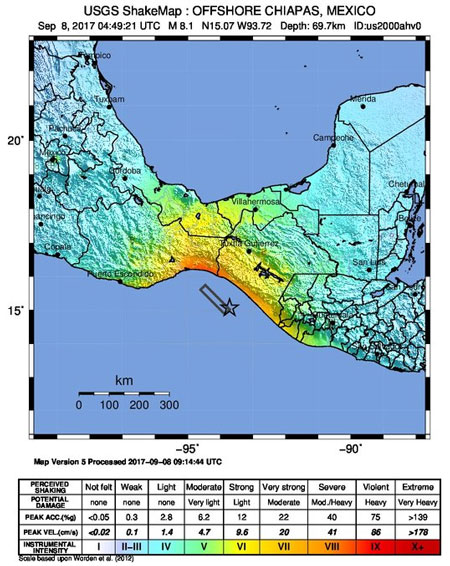
A major earthquake has struck off the coast of the Mexican state of Chiapas. The U.S. Geological Survey (USGS) has estimated the magnitude at 8.1, with a focal depth of 70 km. The epicenter of the event, which occurred at 11:50 p.m. local time, September 7 (4:50 UTC, September 8), was located 87 km southwest of Pijijiapan (est. pop. 15,100) and about 1,000 km from the capital, Mexico City. It was the highest magnitude earthquake to affect Mexico in a century.
Seismotectonic Background
According to the USGS, the event occurred at a location where the Cocos plate is converging with the North American plate at a rate of about 76 mm/yr. Given the rupture mechanism, depth, and location, it is likely an intraplate event within the deeper Cocos slab. While it will take some time to estimate the size of the rupture plane, an event of this magnitude would typically produce a rupture plan of about 200 km x 50 km.
In the last 100 years, 8 other earthquakes of magnitude 7 or greater have occurred within 250 km of the current event. The largest of these was a M7.4 earthquake off the coast of Guatemala in 2012.
 ShakeMap for September 8, 2017, magnitude 8.1 earthquake near Chiapas, Mexico. Source: USGS
Reported Impact
At least 32 people have been killed by the quake, but that number is expected to rise. Damage reports are only just beginning to come in, but indications are that multiple buildings in Chiapas and Oaxaca have collapsed. A tsunami warning was issued, but thus far the highest reported wave was at 3 feet. Nearly 2 million homes lost power, but most have since had their service restored. Aftershocks continue, with at least 5 above magnitude 5.0. It is very possible that larger aftershocks in the 6.0-7.0 range will be felt in the coming days and weeks. Around 1,000 army troops have been dispatched to help with rescue and recovery.
The quake set buildings swaying in Mexico City, some 1,000 km to the northwest. Residents fled into the streets, windows broke and some walls collapsed. Mexico City sits atop what once was Lake Texcoco. The lake was artificially drained in the 1600s and, today, the lakebed soils beneath the capital are made up of silt and volcanic clay deposits 50 to 100 feet deep. These resonate with long-period waves coming from long distances and, indeed, in 1985, a M7.1 earthquake off the coast of the state of Michoaca, hundreds of miles from Mexico, collapsed more than 800 buildings in the densely populated capital region. Mexico City seems to have been largely spared from the effects of today’s quake, but it serves as a jarring reminder of the possibility of large losses.
Exposure at Risk
Areas of the coast of Mexico nearest the epicenter are relatively sparsely populated, and Chiapas ranks the poorest of Mexico’s states. The majority of residential buildings in Mexico are of masonry construction, falling into one of three classifications: reinforced masonry, confined masonry, and unreinforced masonry. Unreinforced masonry buildings are one of the construction types most vulnerable to shake damage and are likely to be the most ubiquitous in the small coastal towns of Chiapas, along with more informal construction, such as adobe. Commercial buildings in Mexico are primarily of engineered masonry or concrete construction, and are better able to withstand ground motion.
In large urban areas, such as Mexico City, most middle- to upper-class families live in five- to fifteen-story tall reinforced concrete commercial dwellings. These buildings are generally well designed and built with high quality materials.
Building codes in Mexico are among the most comprehensive in the world, but there are no national codes (each of the more than 2,400 municipalities in Mexico enacts and enforces its own regulations), and code enforcement can be weak and designers and contractors often do not fully apply building regulations.
It is still in the very early aftermath of this event and the towns that will be most severely affected are remote. It will be hours and possibly days before the extent of damage becomes clear. The AIR earthquake team will continue to monitor data from the earthquake and provide additional information if warranted.