M6.4 Hualian Taiwan Earthquake
Status: Closed
| Type of posting | Posting date(EST): | Summary | Downloads |
|---|---|---|---|
| First Posting | 2/7/2018 5:00:00 PM |
|
|
First Posting | Summary
Posting Date: February 7, 2018, 5:00:00 PM
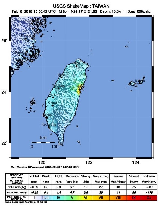
An M6.4 earthquake struck just north of Hualian, Taiwan, near midnight local time on Tuesday, February 6, leaving at least four high-rise buildings partly collapsed or leaning precariously. Officials report dozens missing or trapped, and at least 7 deaths. Coming just two days after an M6.1 struck nearby, the quake destroyed homes, damaged bridges, and buckled roads around this northeastern coastal city. The shallow quake was felt as far away as the capital city of Taipei about 120 km (74 miles) to the north, according to USGS reports. It has been followed by a series of strong aftershocks centering in the same area north of the city, including an M5.7 today, Wednesday, February 7 at 15:21 UTC.
Around 1,900 households lost power, according to the Central Emergency Operation Center, and most had it restored by Wednesday morning, although an estimated 35,000 residents were still without water at that time. Bridges and some roadways remain closed until inspections prove they are safe for travel, although local airports and rail services remain fully operational. More than 600 military personnel and more than 750 firefighters are looking for survivors amid the rubble and helping with rescue efforts, according to Taiwan's Central Emergency Operation Center.
Seismology
The island of Taiwan is part of a collision zone between the Philippine Sea plate and the South China microplate at the southeastern margin of the Eurasia plate. This oblique convergence, occurring at a rate of ~80 mm/year, has resulted in the rise of the Central Mountain range and has distributed active faulting across the island. The major active fault zones include the Longitudinal Valley Fault Zone along the eastern coast of Taiwan. The earthquake ruptured a short distance north of the northern termination of the Longitudinal Valley Fault Zone—a tectonically complex area due to its intersection with the Ryukyu subduction zone. The rates of historic seismicity in this region are among the highest for Taiwan.
Exposure at Risk / Building Codes and Enforcement
Multi-story concrete, steel, and masonry dominate construction in Taiwan, particularly in urban areas. Often in Taiwan builders widen openings at the ground floor level for commercial use, a practice that can result in a “soft-story,” which generally compromises a building’s seismic performance if not carefully compensated for.
Prior to 1974, Taiwan lacked an enforced seismic provision. Consequently, buildings constructed during that period could experience severe damage in earthquakes. One of the four collapsed buildings—the Marshal Hotel—in this February 6 earthquake was constructed in the 1960s. Since then, several major building seismic design codes were enacted—in 1974, 1982, 1997, 1999, 2005, and most recently in 2011. The provisions were not well followed until after 1997.
Prior to the 1999 Chi-Chi quake, building codes were designed to withstand shaking from deeper, offshore events. Caused by reverse motion along the Chelungpu crustal fault, the Chi-Chi event had a shallow focal depth and exerted forces that exceeded maximum design specifications then enforced. At the time, many residential buildings were built with tall, open first floors designed for storefronts and public use, as noted above. Many of the buildings that collapsed in the Chi-Chi quake had been made unstable due to the soft-story effect that results when designs of load-bearing walls differ between the first and upper stories of a building.
After the 1999 Chi-Chi earthquake collapsed more than two dozen apartment buildings and killed more than 2,400 people in central Taiwan, building codes underwent a detailed overhaul and the new provisions were released in December 1999. Performance-based engineering was included in the codes in 2005. Since then, the code provision in Taiwan has been strictly enforced.
 ShakeMap for February 6, 2018, M6.4 earthquake near Hualian, Taiwan. Source: USGS
First Posting | Downloads
Posting Date: February 7, 2018, 5:00:00 PM
Similar Stochastic Event IDs
Note: These lists give event IDs taken from our stochastic catalog that have similar characteristics as the current event.
| Product | File Type | Description | Download |
|---|---|---|---|
| CATRADER | xls | Selected set of simulated scenarios | |
| TOUCHSTONE | xls | Selected set of simulated scenarios | |