Update 1 | Summary
Posting Date: March 15, 2010, 8:00:00 AM
AIR Worldwide estimates that insured losses in France, Belgium, Denmark, and Germany and Netherlands from winter storm Xynthia will be between 1.5 billion and 3 billion Euros.
AIR’s industry insured loss estimates reflect:
• Insured physical damage to property (residential, commercial, industrial, auto), both structures and their contents
AIR’s insured loss estimates do not include:
• Business interruption and additional living expenses (ALE) for residential claims(note that clients’ business interruption exposures can be modeled in CLASIC/2™)
• Losses to forestry
• Losses to infrastructure
• Losses from non-modeled perils, including coastal surge and inland flooding
The strong extratropical cyclone (ETC) made landfall Saturday evening, Feb. 27th, in the northern provinces of Spain and Portugal. It then moved northeast over the Biscayan Sea into central France before losing intensity on its path through Germany and eventually dissipating over the Baltic Sea.
Xynthia brought with it a potent combination of hurricane-force gusts and torrential rains, causing significant travel disruption and property damage across parts of Spain, France, Belgium, and Germany.
Within the last two weeks, a cluster of three winter storms—Undine, Wera and Xynthia—moved into Europe only a few days apart, and each of them tracked along a strong southerly jet stream across a region north of the Canary Islands. Among the three storms, meteorological conditions were most favorable for Xynthia’s development because the storm formed farther south than the other two and therefore was able to tap into an unusually warm and moist air mass. Enhancing the amount of available moisture for Xynthia was the presence of unseasonably warm sea surface temperatures of 14 degrees Celsius.
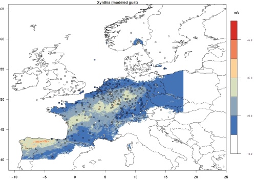
Reported observation data for the storm include gusts up to 140 kilometers per hour (km/h) in areas of lower elevations across Spain, France, Germany, Belgium, and Denmark. At the Brocken weather station in Germany, a peak wind gust of 180 km/h has been reported. Xynthia’s minimum pressure was 966 millibars (mb) as it reached Spain and dropped to a minimum pressure of 980 mb while traveling over Sweden.

Map of modeled wind gusts in meters per second. Source: AIR Worldwide
Comparisons have been made between Xynthia and winter storms Lothar and Martin (1999), and with Klaus, which struck southern France last year. The wind speeds of Xynthia were generally not as intense as any of these storms, however. In fact, Xynthia’s wind speeds were closer to those of Herta, which was one of a devastating series of storms that affected Europe over a five-week period in the winter of 1990, though Herta tracked over a region of slightly higher exposure. Observed losses for Herta are about €2.3 billion trended to today’s exposure.
France was the hardest hit by Xynthia, with the storm uprooting trees, flooding houses, and wreaking havoc with transportation. Unreinforced masonry construction is common throughout France. At the wind speeds recorded for winter storm Xynthia, AIR engineers generally expect damage to be restricted to the outer shell of a building including roof tiles, chimneys, and windows. Some structural damage may be observed in older buildings with poor construction quality.
Many of France’s sea walls, including those around the Il de Re, were damaged or washed away. With the combination of high tide and strong winds, the storm increased sea levels to over a meter above normal and generated waves as high as 8 meters in the Vendee and Charente-Maritime regions. While the storm has subsided, high tides continue to threaten areas where high sea surges have already breached dikes along the coast.
By Monday night, about 10,000 people had been evacuated from their homes on the Atlantic coast and French electricity distributor, EDRF, has reported that 50,000 homes and businesses remain without electricity. More than 9,000 rescuers in helicopters continue to search flooded homes for missing people. The French government has classified the storm as a natural disaster, clearing the way to expedite claims processing in France. Flood damage is typically not covered in home insurance contracts, but the government-backed “CAT NAT” insurance pool will cover all non wind-induced losses.
In Germany, the storm cut roads, cancelled flights, and shut down the rail system in about one-third of the country. Severe winds uprooted trees and tore off roof tiles, and fallen tree limbs and signage caused building damage in Heidelberg, Rheinland-Pfalz, Düsseldorf, Cologne, and Baden-Württemberg.
While the size of individual claims is expected to be relatively low, the overall volume of claims is expected to be significant due to the size of the affected area. Flood and coastal storm surge losses will likely be substantial.
The AIR meteorological team has assembled the available information in the aftermath of this event and has run simulations using the AIR Extratropical Cyclone model. Scenarios are now posted on the Scenarios page of the ALERT website.
AIR’s team of meteorologists will continue to monitor the effects of damage, and has already initiated a post-disaster survey of damage in the affected regions.
As clients review their estimated losses from this event, AIR recommends the following best practices to enhance the interpretation and communication of results:
• Due to unique nature of this event, clients should use the ALERT event set to estimate individual company losses rather than relying on similar events from the stochastic event catalog;
• Always communicate the range of loss estimates produced by the event sets provided on the ALERT site, not just any single estimate or just the maximum;
• Always make sure the loss results include demand surge;
• Benchmark estimated losses against losses based on market share information and industry loss estimates when appropriate;
• Present any known issues with exposure data quality that might affect the loss results;
• Disclose any adjustments made to reflect non-modeled costs such as loss adjustment expenses, coastal surge and inland flooding.
Note:
An update to the CATRADER® event-sets and loss-scenarios for extratropical cyclone Xynthia has been posted. The update was required to address a discrepancy in the CATRADER files, which was the result of a minor processing omission among certain, small geographical regions within France and Germany. The impact on industry loss estimates is slight—resulting in an increase between 2.5% and 4.5%--which still falls within AIR’s 1.5B€ to 3.1B€ range.
The update does not affect the CATRADER event sets in Belgium or the Netherlands nor does it impact CLASIC/2 event sets and losses. If you have questions about how to run a CATRADER analysis using these event sets, please contact your AIR representative.
