
Mississippi River Flooding
Status: Closed
| Type of posting | Posting date(EST): | Summary | Downloads |
|---|---|---|---|
| First Posting | 5/13/2011 1:00:00 PM |
|
First Posting | Summary
Posting Date: May 13, 2011, 1:00:00 PM
Flooding from a large slow-moving storm system spawned nearly a month ago and encompassing several precipitation events has inundated low-lying communities and farmland for miles along the Upper and Lower Mississippi River. Although the height of the river receded slightly yesterday in Memphis, Tennessee, after nearing record height there earlier this week, towns south of Memphis are preparing for heavy flooding. The governors of both Mississippi and Louisiana warn farmers and residents of waterfront communities to be ready to evacuate in preparation for major flooding along tributaries and spillways as the swollen river pushes record amounts of water towards the Gulf, which it is expected to reach in two weeks. Communities along the river are shoring up levees and monitoring water levels.
The southward moving bulge of river water (known as the flood crest) has left considerable damage in its wake, including in Memphis, where the river came close to reaching record height Tuesday; it crested at 47.85 feet early Tuesday morning, just under a foot below the record (48.7 feet) set in 1937 when another massive flood inundated 20 million acres of farmland in the region. At its height Tuesday, the river was moving at 2 million cubic feet per second and was about three miles wide—roughly three times wider than normal. The gushing water flooded upwards of 3,000 properties in Memphis, including nearly 100 single-family homes. More than 1,300 Memphis residents were forced to evacuate. Nearby, large expanses of farmland were completely inundated, and north of Memphis, four trailer parks suffered heavy flooding. The water level in Memphis began to recede Wednesday night, down about two inches from the peak height reported Tuesday. The National Weather Service (NWS) predicts that floodwaters in the region should begin to withdraw sometime next week.
To the northwest of Memphis, in Missouri, around 100,000 acres of cropland were left flooded by the bloated river. Farmland in the state was turned to swamp after the Army Corps of Engineers detonated sections of a nearby levee there last week in an effort to save local towns. Elsewhere, the flooding stopped barge traffic on the Ohio River, a Mississippi tributary.
To the south, in Vicksburg, Mississippi, floodwater crashed over a 100-year old levee yesterday, Thursday, flooding 12,000 acres of farmland. The river is not actually expected to crest here until May 19, when it could reach 57.5 feet, according to the Corps of Engineers. That is about 1.5 feet above the record height for Vicksburg, established in 1927. Already, however, the rising water has caused two major Vicksburg casinos (each of which employs 2,000 people) to shut down. The local Yazoo & Mississippi Valley Train Station is engulfed by water. As the flooding commences, thousands of Mississippi residents will likely be displaced. While the majority of levees in this region have been performing well so far, a breach here is still a concern; should it happen, it could send a massive surge of floodwater onto the Mississippi Delta, a flat area of farmland and small towns. Already in the Delta, about 600 homes have flooded, though the flood crest is not expected in the region until late next week.
In Louisiana, meanwhile, the floodwaters are threatening oil refineries, as well as residential areas west of the river, prompting Governor Bobby Jindal to urge evacuations and declare a state of emergency in Louisiana. Officials in the state are debating measures to relieve pressure from levees to protect Baton Rouge, New Orleans and residences and refineries in between the two cities. Workers trying to block floodwaters from impacting Baton Rouge—where the river is expected to crest to 47.5 feet on Monday, May 23rd—have raised the lower portions of a levee there. To divert floodwater from New Orleans, the U.S. Army Corps opened a key spillway outside the city on Monday; this will permit excess river water to flow north into Lake Pontchartrain. The Army Corps may also open the Morganza Spillway, which is only opened when 1.5 million cubic feet per second of water flow by the gauge at Red River Landing in northern Pointe Coupee Parish. This water level could likely be reached Saturday. If the spillway is opened, it’ll mark the first time it has been used since 1973; 2,500 people along a 100-mile stretch in Louisiana will be affected by the diverted floodwater. However, if the spillway were not opened, New Orleans may be at risk from levee breaks and flood waters that would result in more significant damage than that that resulted from Hurricane Katrina, according to the New Orleans Times-Picayune.
It is worth noting that when spillways are opened, they make the rivers into which they flow un-navigable to barges. In Louisiana this week, this has disrupted supplies of crude oil to a major state oil refinery. Meanwhile, two other Louisiana refineries are threatened by flood waters, prompting concerns that US oil supplies will take a hit and result in higher gas prices.
The National Weather Service has provided a five day significant river flood outlook for the Upper and Lower Mississippi River Region. This outlook, in the form of a footprint showing significant river flooding occurring or imminent, is shown below.
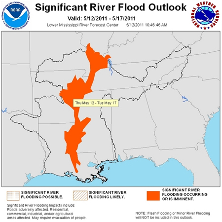 Figure 1: Significant River Flood Outlook from the National Weather Service shows areas either flooded or in imminent danger of flooding. (Source: http://www.srh.noaa.gov/lmrfc/?n=fop)
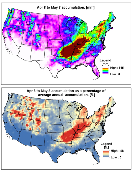 Figure 2: (Top) Precipitation Accumulation for the period April 8-May 8, 2011. (Bottom) Comparison of precipitation data for April 8-May 8 of this year with average annual precipitation accumulations (Source: AIR using data from http://www.cdc.noaa.gov/cdc/data.unified.html).
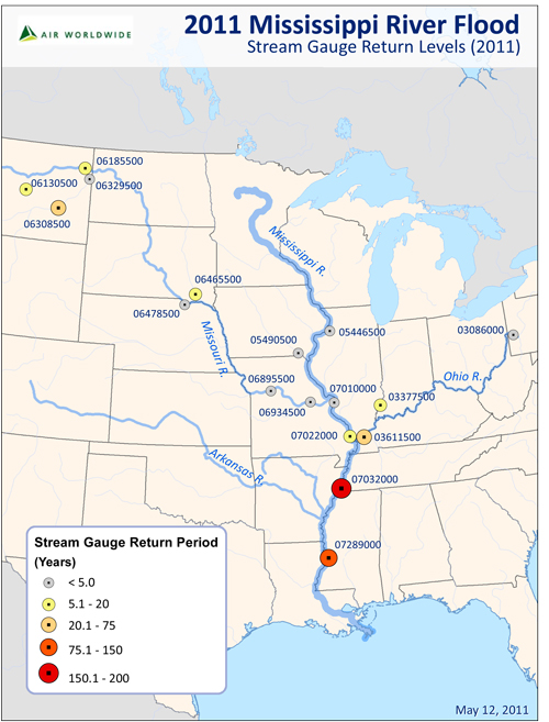 Figure 3: Return periods for available USGS gauging stations reveal that the flooding on the Mississippi River reflects an event with a return period of over 100 years (Source: AIR using data from http://waterdata.usgs.gov/nwis and http://water.weather.gov/ahps/).
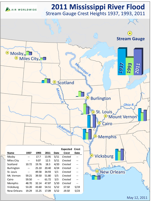 Figure 4: Comparison of water levels for the 1937, 1993 and 2011 great floods; in numerous locations along the Lower Mississippi, the 2011 crest heights exceed record heights (Source: AIR using data from http://waterdata.usgs.gov/nwis and http://water.weather.gov/ahps/).