
November, 2012 UK Flooding
Status: Closed
| Type of posting | Posting date(EST): | Summary | Downloads |
|---|---|---|---|
| First Posting | 11/27/2012 10:00:00 AM |
|
First Posting | Summary
Posting Date: November 27, 2012, 10:00:00 AM
The Current Situation
Heavy rainfall began lashing the British Isles on Thursday, November 22, prompting hundreds of warnings and alerts. As of Tuesday, November 27 at 3 p.m. GMT, there were 182 flood warnings, two severe flood warnings (indicating the possibility of life-threatening floods), and 225 flood alerts in place, affecting virtually every region in England and Wales. The southwest areas of England, particularly the counties of Cornwall and Devon, have thus far borne the brunt of the rainfall, with some places recording more than 150 mm of precipitation during the past seven days (see Figure 1). According to the UK Environment Agency, 960 homes have been flooded, the majority of them in the southwest. The floods have also resulted in at least one known fatality and contributed to several more injuries. In addition to the devastation to homes, businesses, and the loss of life in the affected regions, there has been widespread disruption to rail and transport networks, including the partial closure of major motorways.
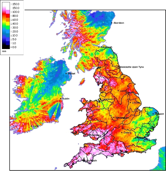
Figure 1. Rainfall accumulation for the seven-day period up to November 26, 9 AM (Source: Environment Agency). While the weather forecast is improving, groundwater and river levels have not yet peaked, indicating a high possibility of continued flooding, especially in the northeast regions of England and northern Wales.
Meteorological Background
The excessive rainfall was the result of consecutive low pressure systems that approached from the southwest, bringing warm, moist air from Africa and the Atlantic. The UK Met Office began issuing flood warnings as early as Monday, November 19 as the first low pressure system was forecast to impact Cornwall and Devon. Heavy rains began in the early hours of the morning of the 21st. At Exeter airport in Devon, 39.2 mm of precipitation was recorded between midnight and 8 a.m. on the 21st. This heavy band of rainfall and gusty winds were the result of a cold front that moved eastwards over the southern British Isles before passing to the east through the Netherlands and across France, bringing some respite late Friday and early Saturday. However, at the southern end of the cold front, which reached down as far as the Iberian Peninsula, another depression was developing. The warm, moist air caused this depression to deepen, and as it moved north-eastward, warnings of heavy rainfall and strong winds were issued, with up to 60 mm of precipitation expected first in the southern counties and then continuing along the path of the storm. As this new system arrived on Saturday, the heavy rains fell on already saturated soils, causing the first floods. The system continued to dump heavy rainfall across the Midlands, across the Pennines, and into the northeast before moving into the North Sea on the evening of Sunday 25. This passing system resulted in rainfall totals, recorded between midnight and 8 a.m. Saturday morning, of 56.8 mm in the town of Plymouth on the south coast and another 48 mm at Exeter airport, where the previous high was recorded days earlier. As the system moved northeast through Saturday night, the counties of Yorkshire and Humberside in the northeast began to see totals of 30–36 mm between midnight on Saturday and 8 a.m. Sunday morning. Yet another low pressure system followed closely behind, again approaching England from the southwest. This system reached the southern counties in the early hours of Monday morning and proceeded along a similar northeast path. The system temporarily stalled over the northeast under the influence of cold winds from the North Sea before finally moving offshore Monday evening. (Satellite imagery of the low pressure systems is available through the Met Office blog, together with some precipitation totals and other information: http://metofficenews.wordpress.com/category/met-office-news/). Rains have continued into today (Tuesday) but are expected to abate later in the day. However, river and groundwater levels are expected to peak in the next 48 hours, indicating the possibility of further flooding.Reported Damage
Since the first flooding began on Saturday, November 24, some 960 properties have been damaged. Disruption to rail and transport networks was also widespread with closures and delays experienced across much of the country. There have also been widespread road closures, particularly in the southwest and the Midlands, including parts of the M5 motorway in Gloucestershire. In the village of Malmesbury near the southern Welsh/English border, floodwaters reached over 1 meter in the center of the town. The mayor stated that this is the worst flooding that Malmesbury has experienced in more than 70 years. Near Bristol, a landslide of several tons of saturated soil forced the evacuation of 10 households. The Elwy River, in North Wales, has overtopped flood defenses with a river height of almost 1 meter higher than the previous record. Approximately 100 homes have been flooded from the Elwy River in the town of St. Aspath, and 400 properties are at risk in the nearby village of Ruthin. Voluntary evacuations were in effect in the town of Tewkesbury in Gloucestershire as floodwaters began to rise on the Severn and Avon rivers. To the north, in York, the River Ouse burst its banks, resulting in the flooding of riverside buildings, including the Kings Arms Pub in the center of the city, which famously displays high watermarks from many previous flood events.
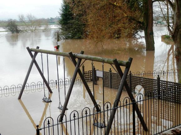
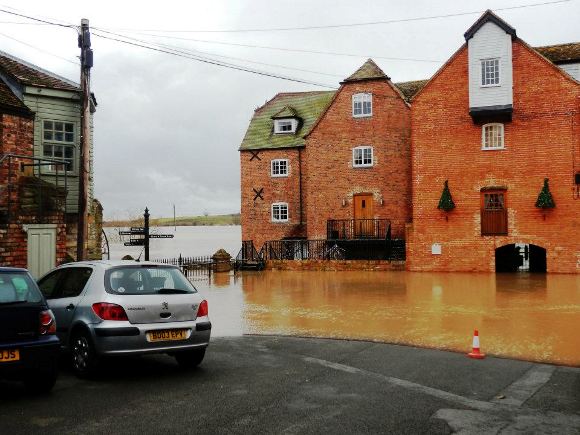
Figure 2. Flooding in the town of Tewkesbury, in Gloucestershire (Source: AIR). According to authorities, an estimated 55,000 homes have been protected from flooding so far by the new flood defenses built since the disastrous flooding in 2007. Newly built flood defenses, however, were overtopped in Kempsey in Worcestershire when one of the pumps designed to redirect the water failed to start. The new defenses cost approximately GBP 1.5 million to build and were designed to protect “the most flooded village in the country” from events such as this; Kempsey has been flooded 20 times in the past 30 years by the nearby river Severn.
Looking Ahead
The current spate of heavy rains and flooding follows a summer in which the UK experienced multiple flooding events. Most of the summer’s floods were localized in nature, with estimates of insured losses totaling approximately GBP 1 billion. AIR estimates average annual insured losses of approximately GBP 540 million, so 2012 is proving to be an above average year. However, 2012 is still far shy of the approximately GBP 3 billion of loss experienced in the devastating 2007 floods. In light of the impending expiration of the government-industry agreement on the provision of affordable flood cover (described in more detail in a recent AIR Currents article), this event reaffirms the need for a suitable resolution. Without an extension to the current plan or a substitution, an estimated 200,000 homes will not be able to purchase or afford flood insurance when the Statement of Principles expires in June 2013. Flood pools are also currently being discussed within the industry, which may bring a hybrid solution to the issue that is agreeable to both the industry and the government.