South Carolina Flooding 2015
Status: Closed
| Type of posting | Posting date(EST): | Summary | Downloads |
|---|---|---|---|
| Update 1 | 10/9/2015 10:00:00 AM |
|
|
| First Posting | 10/5/2015 1:00:00 PM |
|
First Posting | Summary
Posting Date: October 5, 2015, 1:00:00 PM
Ahead of the epic rainfall over South Carolina this past weekend, which continues today, Governor Haley declared a State of Emergency for South Carolina, followed by an emergency declaration from President Obama to authorize federal assistance. Flash flood warnings were issued for Berkeley, Charleston, and Dorchester counties in anticipation of rainfall between 10 and 15 inches. Much more rain than that fell in many towns in those counties.
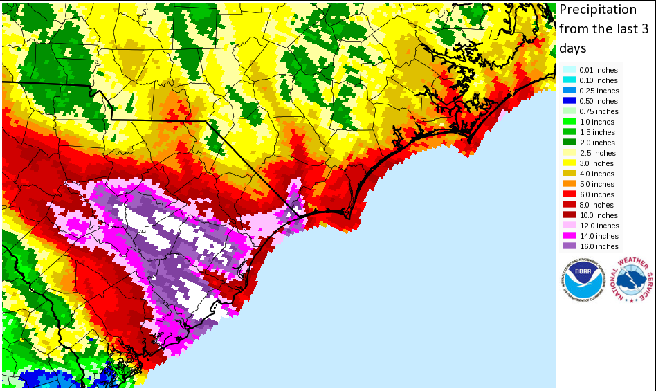
Rainfall records in South Carolina fell nearly as fast as the rain itself, including many for Charleston alone, such as greatest one-day rainfall, which was 11.5 inches at Charleston Airport on October 3. Records for two- and three-day rainfall were also set with slightly higher amounts. The greatest monthly October rainfall record for both the airport and downtown were set with 16.01 inches and 14.25 inches, respectively, as of the afternoon of October 4—very early in the month. Many towns in Berkeley, Charleston, and Dorchester counties received more than 10 inches of rain, with Mount Pleasant in Charleston County receiving 24.23 inches of rainfall (the most of any town in the Tri-County area), the town of Huger in Berkeley County receiving 21.04 inches, and Summerville in Dorchester County receiving 17.23 inches between 7 a.m. on October 1 and 9.a.m on October 4. In addition, the city of Columbia in Richland County reported a one-day rainfall record of 7.77 inches.
Three-day rainfall totals over S.C. and N.C., as of 5:51 a.m. EDT on October 5. (Source: NOAA)
Meteorological History
An extensive band of tropical moisture produced a slow-moving, northwest-to-southeast swath of rainfall across the Carolinas. The event can be attributed to a slow-moving, nearly cut off, upper-level low across the region. Flooding rains were exacerbated by the fact that the band’s movement was nearly parallel with the band’s center axis of orientation. The atmospheric setup that led to the nearly stationary and localized rainfall can most likely be linked to a strong high pressure system across southeastern Canada, the closed low pressure across the region, and Hurricane Joaquin. Joaquin most likely helped re-route what typically would be southerly winds aloft to easterlies, enhancing the protracted rainfall; the strong high pressure system caused the persistence in the deluge. The trend has been for the heaviest rainfall to move from the southwest to the northeast, with the current strongest banding now occurring across North Carolina.
Reported Impacts
This past weekend’s heavy rains are responsible for closing hundreds of roads throughout the eastern part of South Carolina, including a 75-mile section of I-95 and parts of U.S. 17A and U.S. 52. In addition, 127 bridges in the state were closed as well as most schools in the Tri-County area. The University of South Carolina in Columbia, where there is a mandatory curfew in force, was closed due to being cut off from its water supply. There were also many dam breaches, which exacerbated flooding conditions, and power and water were cut off to thousands. Businesses were also closed due to flooding. Hundreds of people were rescued from their homes or vehicles in the Tri-County area over the past weekend, and at least seven have died.
Precipitation of 3-5 inches has been forecast for today in the areas already affected, with the heaviest rainfall now moving into North Carolina. Flash flood threats continue in the Tri-County area in South Carolina, and will increase across Pender and southeast Bladen counties in North Carolina today. However, Tuesday and Wednesday are predicted to be drier.
Local Buildings and Flood Risk
South Carolina has a long history of flooding due to the combined impact of atmospheric conditions and a lack of proper maintenance of flood control and drainage systems. Flood control mitigation efforts have been in place for many years, but South Carolina has a significant number of vulnerable structures despite these efforts. Approximately 85% of the residential construction is wood, with an estimated 20% having basements. The presence of a basement increases the risk for contents and building damage. More than half of the commercial buildings are steel and concrete. Unlike residential structures, these buildings often have engineering attention and are built to stricter standards, but are nevertheless susceptible to high water flow velocities.