South Carolina Flooding 2015
Status: Closed
| Type of posting | Posting date(EST): | Summary | Downloads |
|---|---|---|---|
| Update 1 | 10/9/2015 10:00:00 AM |
|
|
| First Posting | 10/5/2015 1:00:00 PM |
|
Update 1 | Summary
Posting Date: October 9, 2015, 10:00:00 AM
High water levels are still posing a threat in South Carolina, primarily in the Midlands and Lowcountry, and the situation is expected to worsen as rivers continue to rise. The floodwaters, which have claimed at least 17 lives, continue to rise due to excess runoff as the saturated ground cannot absorb more water. Several dams have failed (one intentionally), affecting water supply and worsening the flood threat to several communities. Additional rain is expected to affect some areas over the weekend.
Meteorological Summary
The intense and persistent rainfall over the Carolinas resulted from a combination of several weather systems. As an extratropical cyclone reached the Carolina coast, it became detached from the large-scale westerlies that normally transport such weather systems. Combined with Hurricane Joaquin’s easterly flow, a strong, jet-like region of moisture-laden air developed across the extratropical cyclone’s northern side in the low to middle levels of the atmosphere. This tropical moisture-laden air mass had precipitable water values of 2 inches and greater―anomalously high for the time of year. This air mass moved rapidly inland within the lower levels of the atmosphere across the Carolina coastline and coincided with a rather strong low-level onshore flow attributed to the synoptic location of a high pressure system in Canada. The location of the upper- and lower-level jets and the heavy moisture resulted in a region of intense large-scale lifting and convergence closer to the surface. Hence, thunderstorms developed in the region with rainfall rates of 3-4 inches per hour, which drifted inland and northward before dissipating. Subsequently, new storms developed along this coastal front as the upper-level storm remained nearly stalled for two days. This mesoscale banding of precipitation is often referred to as training, as the movement of the band is oriented along the main axis of the rainfall shield. Significant flash flooding is often a result from training events, as seen in the floods in Texas earlier this year.
Rainfall, Peak River Flows, and Water Levels
The ground had already been saturated from previous storms that affected the area in September, which prevented much of the water from the October rains from being absorbed into the ground. As a result of the record-breaking rainfall for October, a great deal of excess runoff has been produced causing rivers to rise and submerging areas on and off of floodplains. More rain is expected to affect the Lowcountry this weekend.
According to NOAA, the one-day rainfall records for October were broken in at least nine cities, with six of them breaking the one-day record for any month. The total rainfall from October 2-6 exceeded 20 inches in several areas, including parts of Brunswick, Georgetown, and Horry counties. Columbia received up to 17 inches in some areas in less than 24 hours. Over 17 inches have fallen at Charleston International Airport; on October 3 the totals had exceeded 11 inches breaking records of nearly 80 years. By October 7, downtown Charleston had received over 16 inches and over 27 inches fell at Mount Pleasant, while nearly 24 inches fell at Georgetown. Some areas of Columbia received over 18 inches of rain, with over a foot in the downtown area. The rainfall total in Summerville, north of Charleston, reached nearly 18 inches by October 6, surpassing its 117-year record of nearly 11 inches for the entire month of October.
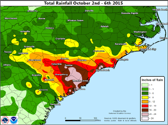
Figure 1. Total rainfall from October 2 through 6, 2015 (Source: NWS)
According to the National Weather Service, the Congaree River, whose flood stage is 19 feet, crested at nearly 32 feet on October 4. Calhoun, Lexington, and Richland counties are all affected by the Congaree River at Carolina Eastman. The North Fork Edisto River at Orangeburg, whose flood stage is 8 feet, crested at 13.6 feet on October 5. The Lynches River at Effingham, whose flood stage is 14 feet, was measured at 18.6 feet on October 7. Also on that day, the Pee Dee River at Pee Dee, whose flood stage is 19 feet, was measured at 22 feet. In Williamsburg County, the rising Black and Santee rivers have caused severe flooding in several communities, and residents in areas south of these rivers were asked to evacuate. On October 8, the Black River at Kingstree, where its flood stage is 12 feet, was at 19 feet. The Santee River was over 18 feet and is expected to reach 23 feet, more than 13 feet above flood stage. The Edisto River near Givhans Ferry, where its flood stage is 10 feet, was at 16 feet on October 8. In Horry County, the Waccamaw River, whose flood stage is 11 feet, was predicted to crest on at about 15 feet.
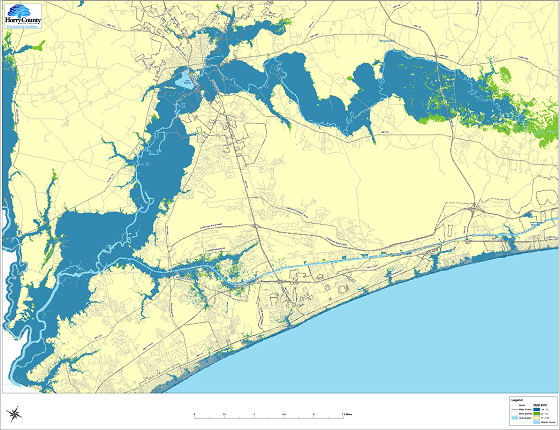
Figure 2. Potential flood areas in Horry County, as of October 6, when the Waccamaw River was expected to crest about 5 feet above flood stage (Source: Horry County Government, available at: http://www.arcgis.com/home/webmap/viewer.html?webmap=7438469ca3a24316a5e2410454524892&extent=-79.2545,33.6224,-78.4965,34.0103 )
The United States Geological Survey (USGS) compiled peak flows based on river gauge data collected between September 28 and October 7. AIR compared these peak flows with the flows from the AIR Inland Flood Model for the United States to estimate the return period at these gauges. Based on this analysis, AIR found that out of 73 gauge stations in South Carolina, six had flows with return periods of 20 to 50 years, three had flows with return periods of 50 to 100 years, two had flows with return periods of 100 to 500 years, and one had a return period flow that exceeded 500 years. These gauges are illustrated in Figure 3.
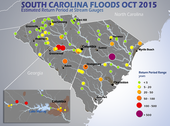
Figure 3. Estimated return periods of flood levels at stream gauges in South Carolina (Sources: USGS and AIR)
Based on the recorded water level at the gauges, the NWS classifies the degree of flooding at each gauge. The peak stages at 33 of the 73 gauges were classified as Near Flooding or higher, with seven of those as Major Flooding, as illustrated in Figure 4.
Note that, in general, the higher flood stages from the NWS tend to correspond to the higher return periods estimated from the AIR Inland Flood Model for the United States. However there can be differences because of methodologies used to estimate the return periods and the intervals used for the flood stage classifications.
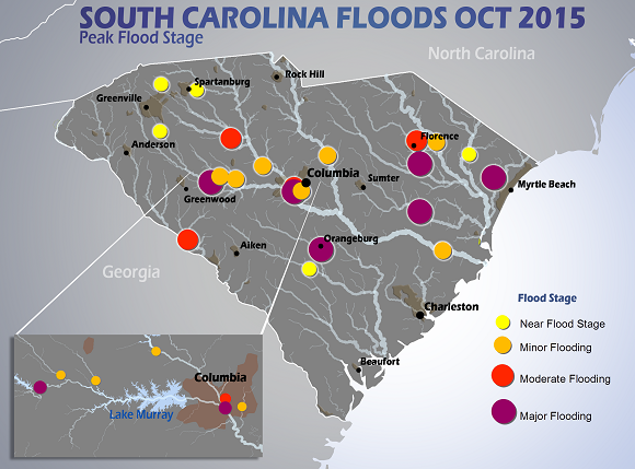
Figure 4. Flood stages at locations in South Carolina based on gauge data (Sources: USGS, NWS, and AIR)
Dam Failures
Numerous dam failures have occurred in several counties. These include the Gibson Pond, Barr Lake, and Old Mill Pond dams in Lexington County; the Clyburn Dam in Lee County; the Upper Rocky Creek/North Lake and Cary Lake dams in Richland County; the Semmes Lake Dam in Fort Jackson County; and the Corbett Lake Dam in Aiken County. The Beaver/Boyd’s Pond #2/Wildwood Pond #2 Dam was breached intentionally to alleviate pressure. Similar to many earthen dams and levees in the United States, some of these dams are susceptible to weakening from rainfall.
Reported Impacts
A disaster declaration is in effect for several counties, and many coastal areas, such as Georgetown, are bracing for the situation to worsen. As of 11 a.m. on October 8, at least 17 people had died as a result of the flooding. Evacuations were under way in several areas threatened by rising rivers or dam breaches. As of October 8, Interstate 95 was closed between Exits 119 to 132 and approximately 250 roads and 100 bridges remained closed. In Lee County, a failed dam flooded a 30-acre pond, which washed out a road. Farmlands have been severely affected, and many crops have incurred damage, particularly soybean, peanut, and cotton.
Potable water shortages were reported in Columbia and on October 8, Palmetto Health Richland shut off its water supply to use a new source of water. The city’s largest hospital is resorting to alternative water sources. A temporary dam was put in place while the Columbia Canal is being repaired. Most of Columbia is still under a boil water advisory.
Figure 5 shows the location of flooded structures (green circles) along Gills Creek in Columbia, S.C. Gills Creek is a tributary of the Congaree River.
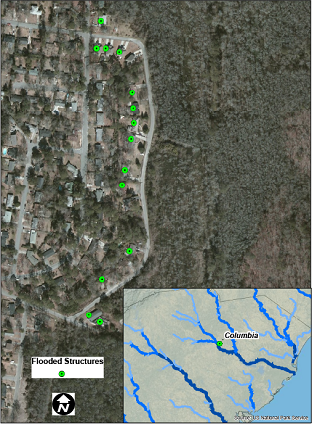
Figure 5. Location of flooded structures along Gills Creek in Columbia, S.C. (Sources: USGS and AIR)
Figure 6 shows the locations of flooded structures (green circles) at the Cane Bay Plantation housing development in Summerville, S.C., located in the Lowcountry region in Berkeley County. The development is located near several lakes and the Santee River, which has flooded severely.
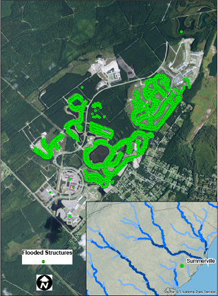
Figure 6. Location of flooded structures at the Cane Bay Plantation housing development in Summerville, S.C. (Sources: USGS and AIR)
AIR’s flood research team continues to monitor the situation in South Carolina and will provide further information if events warrant.