US 2015-2016 Midwest Winter Floods
Status: Closed
| Type of posting | Posting date(EST): | Summary | Downloads |
|---|---|---|---|
| Update 1 | 1/7/2016 2:30:00 PM |
|
|
| First Posting | 12/31/2015 6:15:00 AM |
|
First Posting | Summary
Posting Date: December 31, 2015, 6:15:00 AM
Relentless precipitation in the Midwestern region of the United States has resulted in historic flooding along the Missouri and Mississippi rivers and their tributaries. A state of emergency has been declared in Missouri, where National Guard troops were activated Tuesday to assist with evacuations. In St. Louis, the Mississippi River is expected to crest Thursday and reach its third highest level on record. Flood observations at St. Louis already indicate levels more than 10 feet above flood stage. Severe flooding and breaches of flood defenses have been reported in the towns of Union and West Alton, Missouri.
Meteorological and Hydrological Summary
Persistent precipitation, together with strong winds and tornadoes in the last few weeks, affected two large regions of the United States from Texas to Ohio and from Mississippi to North Carolina. Warmer-than-usual winter temperatures and an infusion of warm tropical moisture created conditions for heavy, sustained rainfall across large sections of the central and southern United States, with many areas experiencing 12 inches of rain or more. The Midwest has endured repeated precipitation events in the last month, including a significant snowfall over the Thanksgiving holiday. Meltwater from the resulting snowpack contributed to the high volumes observed in the Missouri and Mississippi rivers. In mid-December, another winter storm brought heavy snowfall to the Plains states and severe rain throughout the Mississippi River Valley. In southern Missouri, more than 10 inches of rain fell in a period of 36 hours.
A swath of severe storms swept through Texas and much of the Midwestern states over the weekend, resulting in severe thunderstorms and isolated tornadoes. These storms brought incredibly heavy rains to the region around the intersection of Missouri, Oklahoma, and Arkansas. Over a 30-hour period ending Sunday, December 27, 10 inches of rain fell on the south side of Springfield, Missouri. Persistent precipitation continued to fall in the region through Monday and Tuesday, combining with snowmelt to contribute to extremely hazardous conditions along the banks of the Missouri and Mississippi rivers and their tributaries.
As large-scale flash flooding from these weather events begins to recede, the country heads into 2016 with major floods predicted on the Mississippi River that are approaching or even exceeding 2011 flood levels in some areas.
 |
Figure 1. 14-day rainfall prior to December 30 for the continental U.S. showing high rainfall totals (top) and percent of long-term average (bottom) in two regions of the central and southern United States. (Source: National Weather Service) |
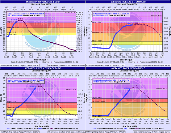
According to the United States Geological Survey (USGS), flash floods that are normally confined to smaller regions were spread throughout large portions of the central and eastern United States. The river flood levels in these regions have reached “major flooding” in 42 and “moderate flooding” in 93 river segments. The USGS defines “major flooding” to indicate extensive inundation of structures and roads, and significant evacuations of people and/or transfer of property to higher elevations. The river waters swiftly rose in the Mississippi River in stretches north of St. Louis, Missouri, and in neighboring tributaries, the Missouri and Meramec rivers. The Mississippi River at St. Louis is expected to peak at 42.50 feet on Friday January 1, registering its third highest level, only behind the 1993 and 1973 flood levels at 49.58 feet and 42.23 feet, respectively. The Missouri River at St. Charles rose close to its major flooding stage and is expected to peak at 35.20 feet early Thursday, December 31. The Meramec River, which joins the Mississippi River downstream from the city of St. Louis, is witnessing historic flood levels at several locations, including the Valley Park and Arnold gauge stations. Water levels at these locations are expected to peak at about 3.5 feet and 2.5 feet above the historic levels of 39.73 feet and 45.30 feet recorded during 1982 and 1993 floods, respectively.
 |
Figure 2. Observed and predicted river flood levels showing major and moderate flooding levels (clockwise from top left) at St. Louis on the Mississippi River, at St. Charles on the Missouri River, near Arnold, and at Valley Park on the Meramec River. (Source: National Weather Service) |
Reported Impacts
Federal officials are monitoring 19 vulnerable levees along the Mississippi River in the states of Missouri and Illinois, where at least 22 deaths have been reported as a result of the flooding.
Flood defenses protecting the city of St. Louis are engineered to provide flood protection to a river stage of 54 feet, more than 4 feet above the record crest set in 1993.
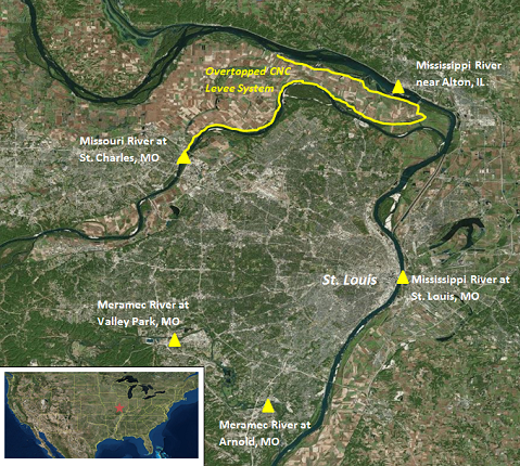
Twenty miles north of St. Louis at West Alton, Missouri, the Mississippi River had begun to breach levees, prompting evacuations. In eastern Missouri, the town of Union was inundated when the Bourbeuse River topped its banks, reaching a record high on Tuesday. Floodwaters in Union, Missouri, were reported to have topped the roofs of businesses as the Bourbeuse River rose to nearly 20 feet above flood stage. Mandatory evacuations were also ordered in Valley Park, Missouri, where rising levels in the Meramec River were projected to surpass historic levels.
In Illinois, a disaster declaration was issued for seven counties in central and southern Illinois, where major flooding continues to be reported. At least seven flooding-related deaths have been reported in Illinois, many caused by flash flooding that swept away occupied vehicles.
A disaster declaration was issued for 21 counties in Arkansas, which is still reeling from the effects of recent flooding and tornadoes. Major flooding is expected along portions of the Arkansas River, where reports indicated levels around 8 feet above flood stage.
Evacuations and road closures are in effect in parts of southeastern Kansas and eastern Oklahoma, where authorities continue to conduct water rescues and assist with the evacuation of residents.
 |
Figure 3. Locations of key USGS river gauging stations on the Mississippi, Missouri, and Meramec rivers and the overtopped levee system near West Alton, MO. (Source: National Weather Service and US Army Corps of Engineers) |
Impact to Industry and Exposure
In the U.S., residential flood insurance is typically offered to homeowners only through the National Flood Insurance Program (NFIP). Established in 1968, the NFIP lets residential property owners purchase flood insurance from the government. An extension of the NFIP has been considered—such that the program would be long-term (currently, it undergoes repeated extensions). The NFIP has been the subject of increasing scrutiny over the years, and it is hoped by some legislators that the current flooding disaster in the U.S. may motivate important changes to this program.
Commercial business can add flood as an endorsement to their property policy, although it is often subject to sublimits. The experience of Hurricane Katrina revealed that commercial insurers did not always have good information about their exposure to flood and indeed estimates of total industrywide insured flood values remain hard to obtain.