Louisiana Flood 2016
Status: Closed
| Type of posting | Posting date(EST): | Summary | Downloads |
|---|---|---|---|
| Update 2 | 9/19/2016 5:00:00 AM |
|
|
| Update 1 | 8/26/2016 11:00:00 AM |
|
|
| First Posting | 8/16/2016 11:30:00 AM |
|
First Posting | Summary
Posting Date: August 16, 2016, 11:30:00 AM
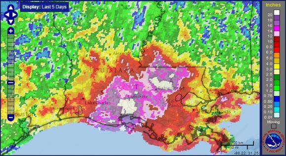
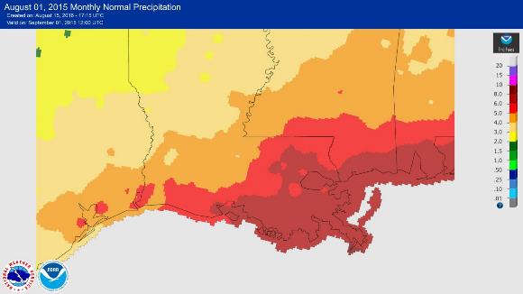
Extensive precipitation-induced flooding in southern Louisiana, from west of Baton Rouge to Mississippi, has resulted in six deaths, tens of thousands of rescues, and significant property damage. (See figures 1 and 2.) Reportedly thousands of homes, as well as farmland, highways, and commercial and industrial property, have suffered flood damage. Water continues to rise in some locales, and additional rain could initiate flash floods. States of emergency have been declared for Louisiana and impacted counties in Mississippi, and the president has designated parts of Louisiana as federal disaster areas.

Figure 1. Significant precipitation occurred throughout southern Louisiana during the 5-day period ending August 15. (Source: National Weather Service.)

Figure 2. Long-term average August rainfall totals for the southern Louisiana region. (Source: National Weather Service)
Meteorological Summary
Record rainfall totals fell across a large portion of southern Louisiana as a slow-moving tropical depression–like system crawled across the region this past week. Rainfall totals ranged mainly from 12 to more than 24 inches, with 31.39 inches recorded near Watson and 27.47 inches in Brownfields; 8.49 inches fell at the Baton Rouge Metropolitan Airport in one day. Parts of the region received two to four times the average total monthly rainfall for August in just three days.
The culprit—the tropical depression–like low-pressure system—intensified as it slowly drifted across the state. Although the storm featured a closed warm core low, because it formed and was maintained inland it was technically not considered a tropical depression. Nevertheless, the counterclockwise (southerly) flow off the Gulf of Mexico—where sea surface temperatures are almost at record warmth levels—brought tremendous amounts of moisture inland across southern Louisiana. Also, precipitable water amounts in the atmosphere were at near record amounts of 2.50-2.75 inches. The combination of these factors, with a lift from the low-pressure system, resulted in slow-moving torrential rainfall and thunderstorms from Lafayette to Baton Rouge. As the storm trekked westward the heaviest rainfall shifted west, too; however, localized downpours continued to plague the area through the weekend.
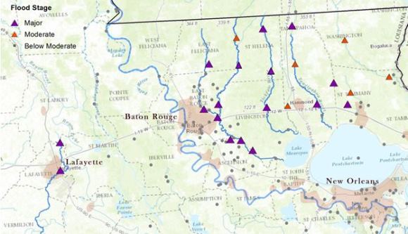
As of Monday, August 15, at least 10 rivers had surpassed moderate-to-major flood stages at several locations along their course: Amite, Bogue Chitto, Calcasieu, Comite, Mermentau, Pearl, Tangipahoa, Tchefuncte, Tickfaw, and Vermilion. (See Figure 3.)

Figure 3. Stream gauges along the Amite, Comite, Tangipahoa, Tickfaw, and Vermilion rivers in southern Louisiana recorded moderate-to-major flooding during the 7-day period ending August 15, 2016. Shading indicates areas of high population density. (Source: National Weather Service, adapted by AIR)
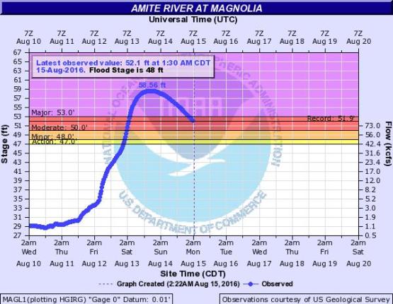
As many as eight rivers have reached record flood levels, including the Amite River (see Figure 4), which crested at Magnolia at about 6.5 feet above the 65-year historical record of 51.91 feet (set in 1977), and the Comite River, which crested near Comite Joor Road about 4 feet above the 70-year historical record of 30.99 feet (set in 2001).

Figure 4. Amite River at Magnolia rose to a record level on August 13, 2016, surpassing the previous record of 51.91 feet, which was set in 1977. (Source: National Weather Service)
Although the heaviest rainfall has passed, many rivers will continue to rise, some for a few days. Because of saturated ground and the current high river levels, additional rain events that occur before waterways have started to recede could result in flash flooding.
Reported Impacts
The drenching rain in southern Louisiana during the past week, from west of Baton Rouge to New Orleans and Mississippi, brought historic inland flooding in many communities. Authorities have reported that to date six people have died. In addition, upwards of 20,000 people have been rescued, plucked from porches and roofs and inundated vehicles by emergency personnel in high-water vehicles, boats, and Coast Guard helicopters.
Upwards of 12,000 people have sought refuge in shelters, some of which have been filled to capacity. (Some shelters, too, have been evacuated due to flooding.) Nursing homes have been evacuated in some communities, and in Baton Rouge critically ill patients were evacuated from a hospital.
According to early estimates, thousands of homes were damaged in each of the following parishes: East Baton Rouge, Livingston, St. Helena, and Tangipahoa. The flooding has also resulted in as many as 40,000 Louisiana businesses and homes losing power. Phone service was affected in Livingston Parish early Sunday when AT&T equipment was flooded, prompting AT&T to erect 11 temporary towers in Baton Rouge and Livingston parishes.
The Louisiana Department of Transportation (DOT) reported that approximately 200 roadways became impassable due to flooding, including parts of both interstates 10 and 12. The DOT added that as many as 1,400 bridges need to be inspected before they can be reopened. In some areas, stranded cars remain on highways.
Governor John Bel Edwards declared a State of Emergency for the entire state of Louisiana, while Governor Phil Bryant of Mississippi declared a State of Emergency for counties impacted in his state. Gov. Edwards also called up 1,700 Louisiana National Guard troops to support rescue work. The federal major disaster declaration for East Baton Rouge, Livingston, St. Helena, and Tangipahoa parishes issued by President Barack Obama makes those areas eligible for federal disaster funding.
Some Louisiana state government offices and schools—including Louisiana State College in Baton Rouge—were closed Monday, August 15, primarily because of the extent of road closures. Flooded roadways throughout the region also resulted in curfews to keep unwary travelers from becoming stranded.
Exposure at Risk
More than 40% of buildings in the U.S. Gulf Coast region meet Flood Insurance Rate Map (FIRM) standards set in 1980. While the specifics of the FIRM standards vary somewhat by building construction and occupancy class, these standards dictate that buildings must be elevated above base flood elevation, as defined by FEMA, and that any parts of a building that remain below base flood elevation must be constructed of flood-resistant materials.
In addition, only 0-10% of buildings constructed since 1980 in the Gulf States have basements (which increase vulnerability to flood damage). Buildings in the region are more typically built on slab foundations, which are designed to withstand flotation, collapse, or lateral movement that can be inflicted by floodwaters. Crawl space foundations in residential buildings in the region are required to have flood openings no more than 1 foot above grade.
In Louisiana, more than 80% of the residential construction is wood, with an estimated 5% having basements. Over half of the commercial buildings are steel and concrete. Unlike residential structures, commercial buildings often are engineered and built to stricter standards, and are thus less vulnerable than single-family homes. Still, mechanical, electrical, and plumbing (MEP) systems can experience severe damage, which results in high losses.