Flooding in Florida and Midwest U.S.
Status: Monitoring
| Type of posting | Posting date(EST): | Summary | Downloads |
|---|---|---|---|
| Update June 24 | 6/24/2024 4:00:00 PM |
|
Update June 24 | Summary
Posting Date: June 24, 2024, 4:00:00 PM
Two significant flood events have impacted different parts of the U.S. over the past two weeks – the first in Florida, and now across several midwestern states.
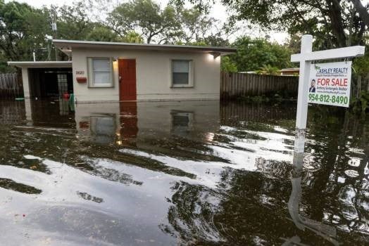
In Florida, the flooding was driven by prolonged intense precipitation - rainfall totals over June 11-12 in some areas around Fort Lauderdale, including Hallandale Beach exceeded a foot, and locally approached 20 inches. A combination of high pressure off the southeast U.S. with moisture coming from the central American gyre directed precipitation from the Caribbean directly into Florida. An unnamed tropical disturbance – “Invest 90L” - passing through the area also contributed. Sarasota County was particularly hard hit as well, with some areas seeing as much as 8 inches of rain in a three-hour period on June 11.
Fifteen inches of rain was reported in West Palm Beach. Fort Lauderdale itself saw about 13 inches, as did Miami Beach, while downtown Miami, Hollywood, and Pompano Beach all clocked in around 10 inches. Water was reported in the lobby of buildings in the Edgewater neighborhood of Miami. While June is typically the wettest month of the year in many parts of Florida, rainfall totals from this event still exceeded monthly long-term averages in Miami and Fort Lauderdale. Governor Ron DeSantis commented that there was likely not enough damage to warrant a federal disaster declaration.

Flood Waters Surrounding a Home in Florida (Orlando Sentinel)
Heavy rain has also been a main culprit in the flooding currently affecting several midwestern U.S. states. Over a foot of rain has fallen across parts of South Dakota (mainly Sioux Falls and southward) and northwestern Iowa over the past week. In Minnesota, similar rainfall totals led to the flooding of the town of Waterville, a town in Le Sueur County situated between two lakes. Thirteen rivers in Iowa are at or near flood stage, and in South Dakota, the Big Sioux, James and Vermillion are all expected to crest within the next 48 hours, with some areas near McCook Lake already devastated by flood waters. Downstream impacts on larger waterways such as the Missouri and Mississippi are also possible as the week progresses.
The Verisk Flood and ALERT Teams are studying the impacts from the Florida event and are monitoring the ongoing situation in the midwestern states. While no ALERTs are scheduled at this time, we will provide additional updates as warranted as the situation continues to develop. In the meantime, please contact your Verisk representative with any questions about these events.