
Texas Flooding
Status: Closed
| Type of posting | Posting date(EST): | Summary | Downloads |
|---|---|---|---|
| Event Summary | 7/8/2025 12:00:00 AM |
|
Event Summary | Summary
Posting Date: July 8, 2025, 12:00:00 AM
Catastrophic flooding is ongoing across Central Texas following torrential rainfall over the July 4th weekend. Flash flooding and the resulting effects have reportedly killed at least 100 people with massive rescue and recovery efforts still underway. Water levels in several rivers in the impacted counties rose to historic levels on Friday overwhelming riverfront communities.
The tragic flooding during the July 3-5 period is a consequence of high atmospheric moisture levels influenced by the remnants of Tropical Storm Barry combined with a slow-moving storm system known as a mesoscale convective vortex (MCV) that produced severe rainfall over the Colorado and Guadalupe River basins. Based on the National Weather Service Quantitative Precipitation Estimate (QPE) data that combines radar and rain gauge observations, 24-hour precipitation of over 12 inches of rain was experienced in several counties, including Mason, Burnet, Kerr, Tom Green, and Concho. During the heaviest 24-hour period, 16 inches of rainfall was estimated near Streeter in Mason County and near Smithwick in Burnet County, and 13.8 inches near San Angelo in Tom Green County. The upstream catchments of the Guadalupe River at Hunt in Kerr County received 11.9 inches of rainfall during the heaviest 24-hour period, corresponding to about 1% probability of occurrence.

Figure 1 - Maximum 24-hour Rainfall Amounts in Central Texas (National Weather Service & National Water Model)
The precipitation accumulations over short time periods were similarly extreme – 6-hour precipitation over 12 inches and 3-hour precipitation over 8 inches were observed over the region, which continued to receive 3-5 inches of rainfall at isolated locations over the last 24 hours.
Figure 1 shows the maximum 24-hour landfall amounts in the impacted Central Texas region, and the black dot is the location of Camp Mystic in Kerr county along the Guadalupe River.
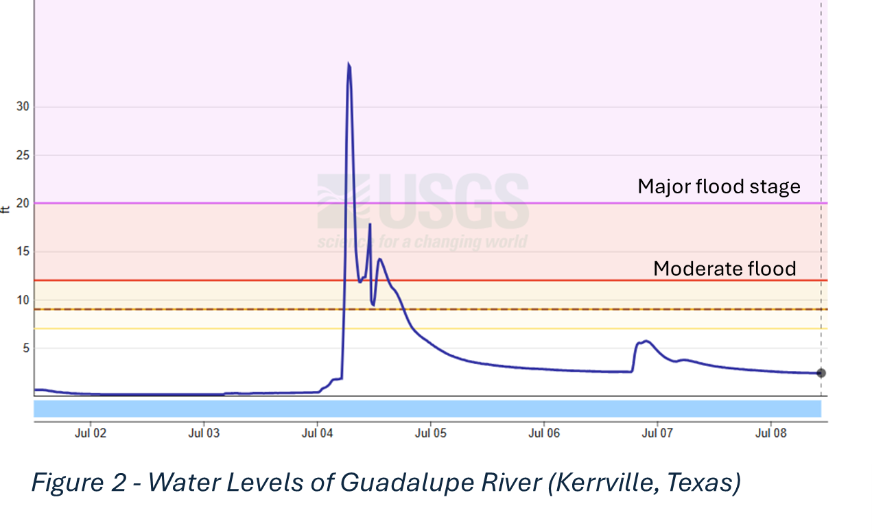
The intense rainfall in the predawn hours Friday inundated the area overnight into the morning, causing the Guadalupe River to swell rapidly and overflow its banks, sparking widespread flash flooding. For example, the Guadalupe River at Hunt in Kerr County recorded a water level of 37.52 feet before the gauge stopped recording for several hours – surpassing the historic water level at this location of 36.6 feet which was observed in July 1932. Water levels rose by over 34 feet in a short 90 minute duration.
The majority of the deaths were reported in Kerr County, a part of the Texas Hill Country northwest of San Antonio. Many of the lives lost include attendees of Camp Mystic, a summer camp on the banks of the Guadalupe River. More than 850 people have been rescued by emergency responders, while many still remain unaccounted for.
The Verisk ALERT team plans to continue to monitor this event as it continues to develop. Please contact your Verisk representative with any additional questions about this event.