
Super Tuesday Tornadoes
Status: Closed
| Type of posting | Posting date(EST): | Summary | Downloads |
|---|---|---|---|
| First Posting | 2/15/2008 11:00:00 AM |
|
First Posting | Summary
Posting Date: February 15, 2008, 11:00:00 AM
On February 5, 2008, at least 401 tornadoes tore through the mid-South, destroying thousands of buildings from Texas to Ohio and killing as many as 50 people. The event, dubbed the "Super Tuesday tornado outbreak," marked the deadliest tornado occurrence in 23 years. Today, ISO's Property Claims Services (PCS) issued a preliminary loss estimate. Based on a survey of affected insurers, the PCS loss estimate is $850 million in insured losses.AIR sent a team to survey the tornado damage on February 7th. The team visited some of the hardest hit regions, including Memphis, Tennessee, where a tornado ravaged a shopping mall, and Jackson, Tennessee, where dormitories and academic buildings at Union University were either damaged or completely destroyed. The AIR survey team also visited sites in Hohenwald and Centerville, Tennessee, as well as the town of Abbeville in Mississippi. The following report details damage from AIR's post-disaster survey.
Please note that AIR has posted a .kmz (Google Earth) file here. Roughly 50 damage photos have been linked. Clients should zoom in on the pushpin icons to reveal individual locations and photos. AIR has also posted an Excel file listing ZIP codes affected by the event. It should be noted, however, that this is not a definitive or final list. The data being collected by the Storm Prediction Center continues to change on a daily basis. It should also be noted that the microevents (individual tornadoes, hailstorms and straight-line windstorms) that make up the larger outbreak are typically highly localized. Thus ZIP Code is at much coarser resolution than the actual damage.
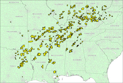 |
| Figure 1. Map of Affected ZIP Codes (Source: AIR) |
Of the sites AIR visited, the worst damage occurred in Jackson, Tennessee at Union University—home to 3,000 students. An EF42 tornado (100 yards wide with a 2 mile track) stormed directly through the center of the 288 acre campus, damaging seventeen buildings, tearing the roof off a main academic hall and destroying 80% of dormitories. Dormitories were constructed of either wood frame, wood frame with concrete block side walls, or brick veneer. All had asphalt shingle roofs. Many of the wood frame dorms sustained damage exceeding 90%, and one—Jelks (Figure 2)—was completely destroyed. The wood frame dorms with concrete block side walls fared slightly better, as did dorms with brick veneer (Adams and Ellis in Figure 3). Contents were entirely destroyed in nearly 80% of the dormitory facilities. Less than 70 yards away, the masonry student center building with built-up roof suffered no damage.
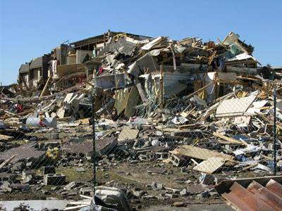 |
| Figure 2. The Jelks dormitory—a wood frame structure—was entirely destroyed. (Source: AIR) |
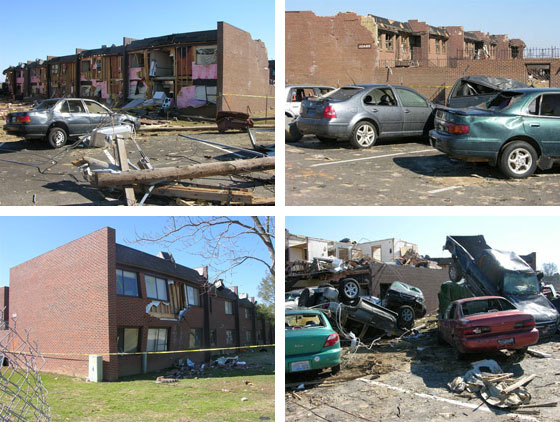 |
| Figure 3. Brick veneer dormitories at Union University. Backside of Adams dorm (top left), front side of Adams dorm (top right), Ellis dorm (bottom left), an unidentified dorm (bottom right). (Source: AIR) |
Across from the dorms, Jennings Hall and White Hall, two masonry academic buildings about 150 feet apart, incurred medium to severe damage to their asphalt shingle roofs. The roof was ripped entirely off Jennings Hall (Figure 4). The tornado also ripped shingles off the Life Way Christian Store and damaged over 1000 cars—tossing many of them hundreds of feet from dormitory parking lots into a nearby field. Cars were flipped and piled on top of each other (Figure 5) by tornado winds. Total damage to the university from February's tornado outbreak has been estimated at $40 million.
 |
| Figure 4. Roof damage to Jennings Hall at Union University (left) and roof damage to Bancorp South near Union University (right). (Source: AIR) |
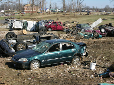 |
| Figure 5. Cars piled in a field on the Union University Campus. (Source: AIR) |
Close by, in the university neighborhood, the E4 tornado caused major damage at the intersection of US-45 and Channing Way, ripping parts of the roof off two banks, including Bancorp South (Figure 4), where the doors and windows were blown out. Other wood frame and light metal commercial buildings, including an Exxon gas station and several restaurants, also suffered tremendous damage, and trees and utility poles in the area were knocked down.
To the southwest of Union University, in southeast Memphis, the AIR survey team visited the Hickory Ridge Mall, where an EF2 tornado (100 yards wide with a 10 mile track) caused extensive roof damage, most notably to Sears and Macy's. Minor damage to the mall's masonry and stucco exterior was observed, while two steel and glass entrances were more severely impacted. In the mall parking lot, nearly 100 cars were totally destroyed by the tornado.
The same tornado caused substantial damage to buildings up to 9 miles from Hickory Ridge Mall, including several commercial structures. About a half mile from the mall premises, the survey team visited several buildings owned by DSC Logistics (Figure 6). Two of these buildings—made of tilt-up walls with corrugated metal roofs—sustained more than 90% damage, including contents. A few miles away, buildings belonging to Sharp Solar Panels Manufacturing Facility and Katt Worldwide Logistics suffered severe damage (Figure 5).
In a local strip mall within the same ten mile radius, large glass windows were blown out of several stores, which also incurred roof and contents damage. In a nearby industrial park, several light metal commercial buildings—including the Hardy Bottling Plant, Memphis Oaks Distribution Center, and all three buildings belonging to TCI Tire (Figure 6)—were completely destroyed or suffered extensive damage. The Hardy Bottling Plant lost 120,000 pounds of anhydrous ammonia, which evaporated into the atmosphere. On the north side of TN-175, more than 20 wooden utility poles and several trees were knocked down.
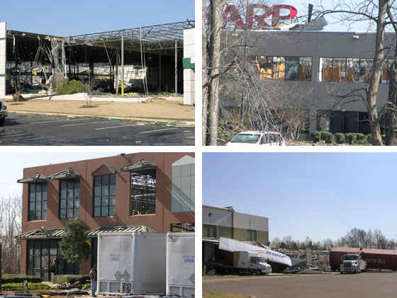 |
| Figure 6. Damaged industrial buildings in southeast Memphis. DSC Logistics (top left), Sharp Solar Panels Manufacturing Facility (top right), Katt Logistics (bottom left), TCI Tire (bottom right). (Source: AIR) |
Elsewhere, in parts of rural Tennessee southwest of Nashville, a tornado obliterated a few small, poorly constructed homes, barns, and garages. All that remained at one home site was a TV, damaged wood from the structure's frame, and insulation. People were busy picking up remnants when the AIR survey team visited the area. In the Brushy community in south Centerville, single family wood frame houses sustained severe or complete damage from an EF2 tornado. The EF2 event took a severe toll on wooden or corrugated metal roofs in the area. To the south, near the city of Hohenwald, an EF1 tornado caused tremendous damage to houses and trailers. Altogether, about 525 homes were destroyed in Tennessee, according to one report.
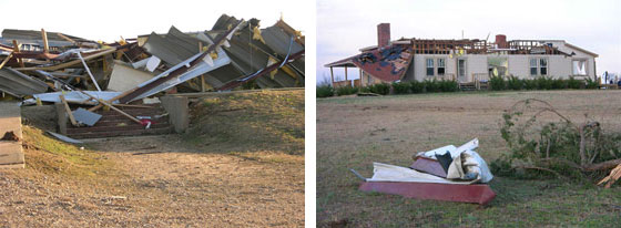 |
| Figure 7. Abbeville, Mississippi. Remains of His Harvest Ministries Church (left) and roof damage to a single family home with brick veneer walls (right). (Source: AIR) |
In Mississippi, residential areas of Abbeville in Lafayette County were hit by an EF3 tornado (1000 yards wide with an 8.5 mile track). The tornado leveled His Harvest Ministries Church (Figure 7)—a wood frame building with a corrugated metal roof. The same tornado completely destroyed two single family wooden frame houses with wood shingle roofs and caused significant damage to single family homes with brick veneer walls and asphalt shingle roofs (Figure 7).
It has been several years since the U.S. experienced such devastating tornado activity so early in the year. In fact, in the past century, only one other tornado outbreak killed so many people so early in the season. This month's severe tornado outbreak was caused by a strong, developing low pressure system that moved out of east Texas during the day. As the system moved into the Mississippi Valley, cold air from the plains was drawn southward. It clashed with the warm, humid air ahead of the system, forming a cold front. The resulting cold front caused widespread thunderstorm formation in the middle of unstable air feeding in from the Gulf of Mexico. A dynamic jet stream located above the system provided the wind shear that fueled the numerous tornadoes.
Some of the tornadoes were strong EF-3 and violent EF-4 twisters. In Tennessee, a single tornado maintained contact with the ground for about 40 miles, according to the National Weather Service. (The typical path of a tornado is 2 miles long.) It touched down near Gallatin in Sumner County and caused 24 deaths as it tracked towards Macon County. In Arkansas, according to the National Weather Service, a tornado with 200 mph winds cut the longest tornado track since 1950—a reported 123 miles in length.
Modeling the losses from actual severe thunderstorm events in real time is an extremely challenging task. These systems are made up of sometimes hundreds of "microevents" (individual tornadoes, hailstorms and straight-line windstorms). These are typically of short duration—sometimes lasting only minutes—and more often than not, they occur out of the range of weather stations or anemometers. When no measured wind speeds are available, scientists must estimate wind speeds from observed damage. The damage itself is highly localized. A tornado may destroy houses on one side of a street, leaving houses on the other side intact.
Furthermore, the data gathering and analysis process usually takes several months. On February 6, for example, the Storm Prediction Center reported 71 individual reports of tornadoes, 112 reports of hail and 194 reports of straight-line wind. These numbers are updated daily, and as of February 15, SPC has recorded 131 tornado reports, 126 hail reports and 267 straight-line wind reports. These will continue to be refined as the data is cleaned of duplicates. PCS is likely to adjust its preliminary loss estimate accordingly.
Additional Resources
Additional damage survey maps and photos are available from individual National Weather Service Stations. These can be accessed by clicking on the interactive map here.
___________
1As of February 14, AIR meteorologists reviewing observations from the National Weather Service have documented 40 tornadoes in Memphis, Nashville, Little Rock and Paducah, Kentucky. Since there was some reported tornado activity outside this area, final tornado numbers are likely to increase.
2The original Fujita Scale, developed in 1971, was updated in 2007 to address a number of perceived weaknesses—hence, what was the F-Scale is now the EF-Scale. The scale classifies tornado intensity indirectly, based on observed damage.