April 22-28 US Severe Thunderstorm Outbreak
Status: Closed
| Type of posting | Posting date(EST): | Summary | Downloads |
|---|---|---|---|
| Update 1 | 5/9/2011 4:30:00 AM |
|
|
| First Posting | 4/29/2011 1:00:00 PM |
|
First Posting | Summary
Posting Date: April 29, 2011, 1:00:00 PM
Across the South, from Arkansas to Virginia, severe thunderstorms and an unusual number of tornadoes (more than 160 reported on Wednesday alone) raged through seven states causing the most loss of life from a natural disaster since Hurricane Katrina in 2005. Whole neighborhoods were destroyed and power was cut to over a million households. The cumulative impact of the continuing severe weather events from Friday, April 22nd (which includes extensive damage in St. Louis), to Thursday, April 28th, has caused Property Claim Services to issue a Catastrophe Serial Number for the period.
On Wednesday, the city of Tuscaloosa in Alabama (population about 95,000) was especially hard hit, as were several areas just outside of Birmingham, the state’s largest city (population 212,000). Fourteen people were killed in the small town of Smithville, Mississippi (population about 900). The National Weather Service has since surveyed the event and has made a preliminary “EF-5” rating of the tornado on the Enhanced Fujita Scale. EF-5 is the highest possible rating (estimated wind speeds of at least 200 miles per hour). This is the first EF-5 rating in Mississippi since 1966. According to the National Weather Service’s survey, most of the homes that were destroyed were well-built, less than 10 years old, and bolted down to their foundations.
More than 200 deaths reportedly occurred in Alabama on Wednesday alone, making it the deadliest day of tornadoes in the United States in four decades. (The current total of loss of lives in all the effected states is more than 300.) The governor of Alabama declared a state of emergency—which was followed by a federal declaration as well—and 2,000 members of the state national guard were called up to help in rescue and recovery efforts.
There are other effects not directly the result of damage. The Browns Ferry nuclear power plant, which is about 30 miles west of Huntsville, Alabama, shut down three reactors as a safety measure. The facility—which produces 3,274 megawatts—will not begin producing electricity again until a full damage assessment of the entire transmission system is completed, thus restricting the amount of power available to the area. Similarly, several auto plants in Alabama are shut down—not because they were damaged, but because their workforce is without power and, in some cases, homes, and many roads are impassable.
This outbreak of tornadoes resulted from the confluence of atmospheric conditions that together created a prolonged period of tornadic thunderstorms in the southeast. Colder air from the northern plains moved southward in the form of a cold front that became established throughout the southern Gulf States. This cold front interacted with warm, humid air from the Gulf of Mexico and resulted in the formation of thunderstorm activity.
However, the primary factor that controlled the severity of the event was a large and very strong jet stream disturbance that moved over the region on Wednesday and Thursday. The strength of this disturbance provided the needed energy to sustain a high level of activity—and thus supported the development of high intensity tornadoes. At the same time, the large size of the disturbance allowed strong storms to develop over a larger area than normally is the case. The combined effect of the jet stream’s influence was the large number of very strong tornadoes that was witnessed over the several days.
This series of developments shows some similarities to those of the previous most deadly tornado outbreak, which happened in April of 1974 and killed 310 people. That event also saw a large, intense jet stream disturbance result in both a large number of tornadoes, and a large number of intense tornadoes. This week’s outbreak was different from the 1974 outbreak in that its frontal system was not as progressive (that is, it didn’t move as steadily eastward). Consequently, the 1974 outbreak covered a slightly larger area.
For the past two weeks, much of the United States has been in a pattern in which thunderstorm activity has occurred where different air masses have come into conflict (where a cold front has separated colder air from the northern plains from warm, humid Gulf air). Periods of enhanced jet stream activity moving over these locations has resulted in the series of severe thunderstorm outbreaks. The repetitive nature of these outbreaks, along with their geographical concentration, is similarly reminiscent of the extended 2003 outbreak—which resulted in $3.2 billion dollars (in 2003 dollars) in insured loss at the time.
It should be noted that none of the individual meteorological elements is unusual. Large, strong jet stream disturbances happen occasionally; persistent frontal features are common, especially in spring; the locations where storms have been occurring are where they are expected to be at this time of year. What is unusual is for all of these risk factors that contribute to the development of severe thunderstorms to align themselves so optimally in the same place at the right time. To get optimal intense instability, shear, and lift all in the same place for a long period of time is a relatively rare circumstance.
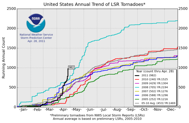
It should also be noted that while the current season’s tornado activity went from unremarkable early on to well above average, there is no indication that this trend will continue. The graph below (http://www.spc.noaa.gov/wcm/torngraph-big.png), from the National Weather Service’s Storm Prediction Center, compares this season’s count of tornado reports with recent past seasons. Note that the current count is likely to be adjusted as data that actually refer to multiple sitings of the same event are eliminated.