
Moore Oklahoma Tornado
Status: Closed
| Type of posting | Posting date(EST): | Summary | Downloads |
|---|---|---|---|
| First Posting | 5/22/2013 1:00:00 PM |
|
First Posting | Summary
Posting Date: May 22, 2013, 1:00:00 PM
At 3:01 p.m. on Monday, May 20, 2013, a massive tornado struck Moore, Oklahoma, a suburb of Oklahoma City, killing at least 24 people, injuring more than 240, and destroying many homes, businesses, and public buildings, including two elementary schools and a hospital. According to reports and aerial images, property damage in the affected region is extensive, with whole neighborhoods heavily damaged or destroyed. Official tallies of destroyed properties, however, are not yet available.
Characteristics and Timeline of the Moore Tornado
Touching down about 5 miles south of Newcastle, Oklahoma, at 2:56 p.m., the powerful tornado tracked northeast for 40 minutes, traveling approximately 20 miles. The Moore tornado was given a preliminary EF-4 rating by the National Weather Service, but was subsequently upgraded to an EF-5 based on damage reports that are consistent with wind speeds over 200 miles per hour. Based on eyewitness reports, video recordings of the storm, and the size of the storm’s swath of destruction, the tornado was approximately a mile wide.
At 2:40 p.m., the National Weather Service Storm Prediction Center (SPC) alerted the town of Moore that a tornado was imminent. At 2:56 p.m., five minutes before the tornado struck, the SPC upgraded its emergency tornado warning to include “heightened language,” stating that those in the path of the storm would be facing a life threatening situation and must take cover in a basement, storm shelter, or interior room. At 3:01 p.m., the tornado struck Moore and continued northeast, nearly paralleling Highway 37, eventually dissipating about 5 miles east of Moore.
Meteorological Conditions That Produced the Storm
A slow-moving, upper-level low pressure system triggered a series of severe thunderstorm outbreaks across the Central Plains starting on May 19. The system coupled with very warm, humid air moving northward out of the Gulf of Mexico ahead of a surface cold front and wind shear associated with an approaching increase in jet stream energy. Together, these factors produced the highly unstable atmospheric conditions that caused the Monday afternoon storms to rapidly evolve into tornadic supercell thunderstorms. The tornadoes spawned by these supercell events were long-lived due to the orientation of the track and the severity of the conditions, leaving behind long and wide swaths of damage. In all, this system produced 22 tornadoes on May 20, largely in Oklahoma, although tornadoes were also reported in Missouri, Texas, Kansas, Arkansas, and Colorado. (However, of these 22 tornadoes, the Moore event was by far the most damaging.) Many localized hailstorms occurred in the region as well, with quarter-size hail noted in Missouri and baseball-size hail reported in Osage County, about 100 miles northeast of Oklahoma City.
The associated upper level system and the surface cold front will be slowly moving east and northeast over the next couple of days. Therefore, a wide area of the central United States—including parts of Texas (including the Dallas region), Missouri, Illinois, Indiana, and Pennsylvania—may be at risk for strong winds, hail, and tornadoes as the week progresses.
Reported Damage
Two schools, the Plaza Towers Elementary School and the Briarwood Elementary School, were nearly leveled by the storm’s high winds and debris impact. The façade of Briarwood Elementary was punctured by cars thrown by the tornado. A nearby hospital, the Moore Medical Center, was heavily damaged, losing its entire top floor to the storm. In addition, several blocks of residential neighborhoods were completely destroyed.
The Will Rogers World Airport was closed for several hours following the storm, reopening Monday evening at about 5 p.m. (local time). As of Tuesday morning, 38,000 households are still without power. The municipal water system of Moore is also offline, according to Mayor Glenn Lewis. Downed power lines and debris-choked streets are hampering the rescue effort, which is still under way.
Although basements and underground shelters are the safest refuge from a tornado, many homes in Oklahoma are built on concrete slabs—and thus lack basements—because the underlying caliche (rock-like soil) layer in the region renders basement construction costly.
An official estimate of the number of destroyed homes has not yet been released; however, the 1999 EF-5 tornado that followed a similar path to Monday’s Moore tornado destroyed more than 8,000 homes (see Figure 1).

Figure 1. Comparison of the storm track of the May 3, 1999, Tornado and the May 20, 2013, Moore Tornado (Source: NWS) AIR estimates that the replacement value of properties within a 0.4-mile buffer zone around the track of yesterday’s tornado (for a total width of 0.8 miles) is USD 2.2 billion. Within a 1-mile buffer zone of the storm track (for a total width of 2 miles), AIR estimates a total replacement value of USD 6.4 billion. These two buffer zones, and the differing estimated replacement value associated with them, reflect the uncertainty in the exact size of the tornado. However, it is important to note that the exposure within each buffer zone is not equally at risk from damaging winds. In fact, exposures on the periphery of the 1-mile buffer zone would experience wind speeds of F-0 force, and hence much lighter damage, than exposures within the 0.4-mile buffer zone. Touchstone-ready shapefiles that capture the tornado’s path and intensity along the path are available on the Downloads page. The files are based on information provided by the NWS as of May 21, 2013.
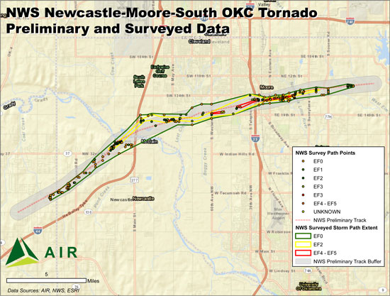
Figure 2. [Updated 5/22/13] Original tornado track provided by the NWS and an updated track based on NWS-data as of May 21, 2013. Note that the replacement value estimates provided here are based on the original track. Touchstone-ready shapefiles for the updated track are available from the Downloads page. (Source: AIR) Expected Pattern of Damage Residential structures in the affected area are typically of wood-frame construction, which are more vulnerable to high winds and windborne debris than masonry structures. Commercial buildings are, on average, less vulnerable than residential structures or automobiles, but they exhibit a broader damage distribution due to wide variations in construction practices and design. Light metal structures are the most vulnerable to high winds and can suffer severe to complete damage from tornadoes categorized as EF-2 or higher. For all types of structures, roofs are often the first element to be damaged by tornado winds, because once a single shingle is removed, neighboring shingles can easily be penetrated and lifted. Tornado winds can peel off unsecured slates, roll metal roofs, and damage windward overhangs and eaves. In the direct path of the tornado, failure of the roof system weakens lateral support of walls, contributing to their collapse. On the periphery of the track, lower damage ratios are expected. Ongoing Damage Assessment Damage assessments from the National Weather Service are ongoing, and it will take weeks to develop a more complete picture of the destruction. The AIR severe thunderstorm team is continuing to monitor reports as they come in to the NOAA Storm Prediction Center and the NWS (see Figure 3). AIR will dispatch a survey team to the affected areas once search and rescue efforts have ended. Additional information may be made available to ALERT subscribers, as warranted.
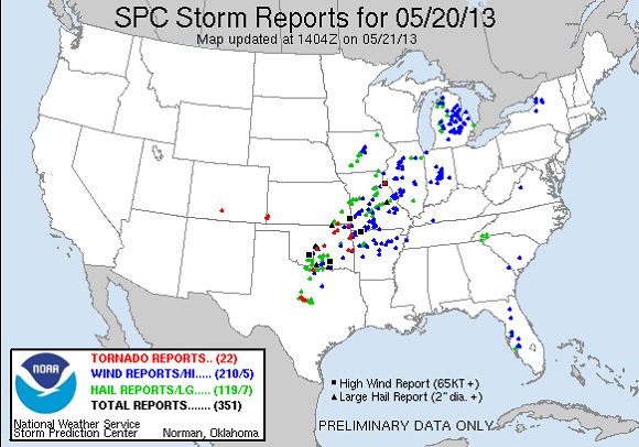
Figure 3. Storm Prediction Center Reports for May 20, 2013 (Source: NOAA SPC)