Severe Thunderstorms in Germany France and Belgium
Status: Closed
| Type of posting | Posting date(EST): | Summary | Downloads |
|---|---|---|---|
| First Posting | 6/12/2014 2:00:00 PM |
|
First Posting | Summary
Posting Date: June 12, 2014, 2:00:00 PM
Current Situation
Severe thunderstorms have pummeled western and central Europe, bringing extremely strong and damaging winds, large hail, rampant lightning strikes, and heavy downpours. The storms have affected a large area as far south as northern Italy and east into Poland, although the worst hit are Germany, France, and Belgium. Severe thunderstorms and high temperatures are affecting other areas as well, including several Central Europe countries, where forest fires sparked by lightning strikes have spread as a result of the intense heat. According to officials, the storms that hit Germany’s North Rhine Westphalia region are the worst in 20 years.
Meteorological Conditions
Huge supercell thunderstorms have pummeled western and central Europe since June 7 due to a cold front that moved into the region from the west, immediately following a severe heat wave. Wind speeds of 130 km/h were recorded in Charente, France and reached 150 km/h at the Düsseldorf airport in Germany. Temperatures on Tuesday, June 10, reached the 36.7°C (98°F) in the Bavarian city of Kitzingen, Germany, the highest on record for this time of year. Germany, as well as Austria, the Czech Republic, Slovenia, and several other countries in Central Europe sweltered under temperatures in the 30s °C (80s-90s°F).
There have been frequent reports of hail reaching 3 cm in diameter throughout North Rhine-Westphalia. In Baden-Württemberg an isolated hailstorm produced hailstones reaching a diameter of 7 cm, while 12 cm hailstones were reported in parts of France. Between 2 p.m. Monday and 8 a.m. Tuesday, more than 110,000 lightning bolts were reported in Germany, while over 23,000 were reported in France.
Reported Impact
Belgium
On June 7, the thunderstorms reached Belgium dropping golf ball-size hail in some areas (including Brussels, where it disrupted a pre-World Cup match between Belgium and Tunisia). Tielt, Sint-Niklaas, Wallonia, and Antwerp were also affected by heavy rain and hail. In the Waasland area of Antwerp, golf ball-sized hail damaged windows and cars, and closed two tunnels including the Bolivar Tunnel. Lightning and hail caused damage and injuries in Wingene and Knesselare where hailstones reaching 5 cm in diameter were reported.
France
On June 8, the storms moved into France, bringing high winds, downpours, lightning, and tennis ball-sized hail (reaching 12 cm in diameter in some areas). Roof damage caused by wind, hail, and flooding was reported in the Val d’Oise and Yvelines areas. In Mormant, roof damage was widespread, affecting homes and businesses, including at least one school. The worst-affected areas around Paris were Essonne and Seine-et-Marne, east of Paris, where hailstones as large as 10 cm were reported. Other affected areas of France included Normandy and Dordogne. Vineyards across France sustained damage from hail and high winds, including 1,000 hectares in Bordeaux and 680 hectares near Blaignan. In Charente, winds reached 130 km/h and both the city and surrounding vineyards were battered by hail and rain. After a brief respite Monday morning, additional storms returned to France and persisted until Tuesday morning.
Germany
On Monday, June 9, the storms took a deadly turn as they claimed six lives in Germany, and seriously injured dozens of others. The storms inflicted damage in large parts of the country on the last day of the country’s holiday weekend. The worst damage occurred in Germany’s most populous state, North Rhine-Westphalia, which was hit Monday evening. In that state’s capital city of Düsseldorf, falling trees killed six people, smashed cars and homes, and blocked roads and railways. Huge traffic jams stretched for 270 km along the major roadways in the area on Tuesday, June 10. Heavy winds at Düsseldorf's airport, Germany’s third largest, reached 150 km/h on Tuesday night, causing air traffic delays due to grounded planes. Heavy winds toppled trees and caused further damage and casualties in Cologne and Essen. Emergency services and armed forces have been dispatched to assist with the cleanup efforts in Düsseldorf and elsewhere. The thunderstorms also caused significant crop damage in Germany, especially in areas west of Kassel.
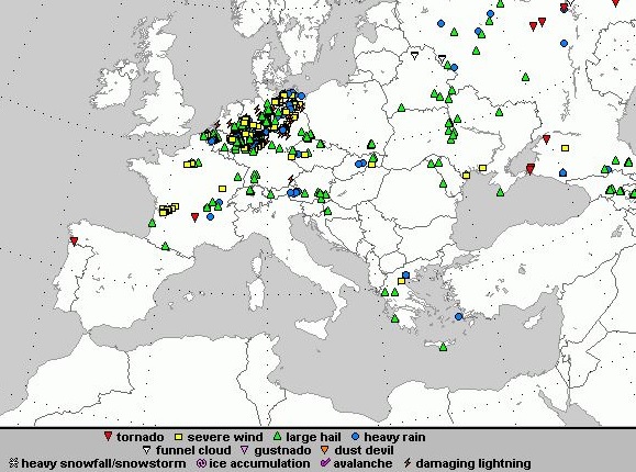
The storms continued eastward into Lower Saxony where warnings were issued for Hanover and Bremen. In several cities of Lower Saxony, roof fires were ignited by lightning. Damage and disruption of public transportation occurred in other states including Mecklenburg-Vorpommen, where flooding was reported in several areas, including Rostock, where 20 mm of rain fell within a short time period. By Tuesday evening, storms were still causing significant damage in Hessen, affecting Kassel, Göttingen, and other cities. Flooding in Kassel was widespread, affecting many cellars in homes and commercial buildings including a hospital, from which patients had to be relocated, a school, and a major train station. Severe weather in Europe from June 7-12, 2014. (Source: European Severe Weather Database)
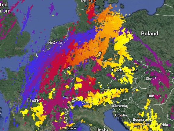
 Lightning from June 9 – 12 across Western Europe. Lighter colors are more recent reports (Source: Lightningmaps.org).
Disruptions in Germany’s Public Transportation
As of Wednesday, June 11, many parts of Deutsche Bahn’s railway system remain closed, and many S-Bahn trains are still cancelled. Frankfurt’s train station was damaged, forcing the cancellation of long-distance trains to and from the city, including a portion of the high-speed train from Munich to Berlin. According to Deutsche Bahn officials, damage in the Rhine-Ruhr region is worse than what was seen in 2007 when the area was struck by winter storm Kyrill.
As of Thursday, June 12, at least 16 trains are still stranded on tracks due to blocked rails and have had to be evacuated. Helicopters are being used to assess railroad damage as some areas are currently not accessible by any other means. Travel by other means including buses, streetcars and local and regional rail travel is still extremely difficult, particularly in Düsseldorf and the entire Ruhr area.
Exposure at Risk
Residential building stock in Europe is predominantly of masonry construction. Mid-rise residential buildings generally have exterior non-load bearing walls made of masonry although they may have light-gauge steel stud walls or concrete panels. Reinforced concrete can also be found in most European countries, especially for mid-rise apartment buildings, while steel is used for high-rise apartment and condominium buildings that are usually located in large urban areas. For commercial exposures, the construction type is approximately 50% masonry with the remaining construction split between steel frame and reinforced concrete.
When built areas are subjected to the level of winds reported here, most of the damage is limited to the rooftops and chimneys of residences, although walls can be damaged by flying debris and toppled trees. Strong winds can also damage cladding. In Europe, rooftops often experience tile damage, with many tiles broken and blown off due to wind force. Uplift of the roof edges allows the wind to penetrate underneath the roof membrane, which raises the pressure and can remove the roof covering. At very high wind speeds, the integrity of the entire structure can be compromised, particularly in cases where the roof provides the lateral stability by supporting the tops of the building’s walls. Hail and flying debris can cause extensive damage, particularly to autos and greenhouses.
In Europe, cellars are common in both residential and commercial buildings, increasing the vulnerability to flood damage. The presence of a cellar also increases the risk for contents damage, particularly in the case of heavily-used cellars that enclose recreational rooms, bedrooms, or home offices. Some homes may have entire apartments located in the cellar as well. However, heavily-used cellars usually have better flood defense mechanisms than unfinished ones. The contents in the lower stories and cellars can vary widely depending on the occupancy class.
Reported Loss Estimates
Currently estimates from several insurers indicate that industry-wide losses are likely to exceed EUR 100 million. This is a preliminary estimate however and the figures will likely increase as storms continue in the region and more damage is reported.
Forecast
Recent thunderstorms have brought cooler air into the northern and central parts of Europe. However, temperatures in the Czech Republic are still in the high 30s °C (80s – 90s °F). While the weather was relatively calm overnight from June 11-12, more storms are expected to affect a corridor spanning from the Pyrenees over southern France, southern Germany and the Alps into Slovakia and the Czech Republic. These thunderstorms are expected to begin in the afternoon of Thursday June 12, and will bring additional rain and hail to the region.
AIR will continue to monitor the situation and will provide updates as warranted.