South-Central Severe Thunderstorm Outbreak
Status: Closed
| Type of posting | Posting date(EST): | Summary | Downloads |
|---|---|---|---|
| Update 1 | 4/29/2014 10:00:00 AM |
|
|
| First Posting | 4/28/2014 12:30:00 PM |
|
Update 1 | Summary
Posting Date: April 29, 2014, 10:00:00 AM
Tornadoes, hail, and strong wind gusts continued to pummel the south-central United States on Monday, April 28, 2014, as a massive storm system that impacted at least seven states on Sunday, April 27, 2014, continued across parts of Mississippi, Alabama, Tennessee, and Illinois. The system is forecast to impact several states on Tuesday, April 29, 2014, with southeastern Mississippi through central Alabama having the highest chance of significant severe weather.
Meteorological Summary
The severe weather outbreak that occurred on Monday, April 28, was caused by the continued slow movement of an upper-level low in combination with high levels of atmospheric instability and deep layer shear.
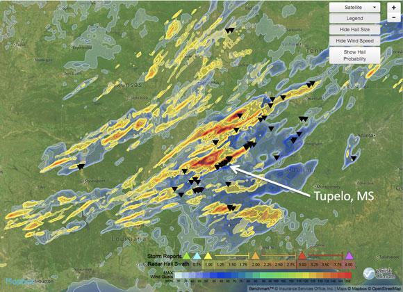
The visualization below is provided by AIR’s sister company, Verisk Climate. The image shows radar-derived hail (yellow) and straight-line wind (blue) activity on April 28; the black triangles represent tornado observation reports.
The radar-based analysis by Verisk Climate of the Tupelo, Mississippi, tornado (location indicated by white arrow) indicates that tornado damage primarily affected areas north of West Main St. This area is characterized by a mix of residential subdivisions and commercial property, including the Tupelo Municipal Airport. The commercial corridors along U.S. 78 and U.S. 45 highways were also in the region of the strongest radar-indicated winds on the north side of Tupelo.
The most intense part of the radar indicates that the tornado traversed a path length of 30 miles, with weaker circulation extending an additional 10 miles. Verisk Climate’s Respond™ service, which provided insight into this tornado as early as 10 p.m. ET on Monday, provides comprehensive, rapid information on the extent and severity of weather-related and other causes of loss for use by insurance claims and enterprise risk divisions. This radar content is provided exclusively to Verisk Climate by their partner Weather Decision Technologies.

Radar-derived hail (yellow) and straight-line wind (blue) activity on April 28, with reported tornado observations (black triangles) overlaid. Source: Respond™ from Verisk Climate
Reported Damage
Several towns in central Mississippi were among the hardest hit areas, as tornadoes caused eight fatalities and major damage to residential and commercial structures. Preliminary reports from Louisville, Mississippi, indicate that a tornado almost a mile wide caused heavy damage to the city’s south side, including Louisville’s main hospital, the Winston County Medical Center. In Tupelo, Mississippi, media outlets are reporting that homes and businesses in the city’s commercial district are completely destroyed. Tornadoes were also reported in Yazoo, Webster, Montgomery, Leake, Attala, Hinds, Lowndes, Madison, Rankin, Newton, and Jones counties.
Alabama is currently under a government-ordered state of emergency, as tornadoes impacted much of the northern part of that state. Preliminary reports indicate heavy damage to multiple homes in Dekalb County, along with the destruction of buildings in Jefferson County, including the Kimberly Fire Department. Tornadoes were also reported in Franklin, Colbert, Lawrence, Marion, Cullman, and Tuscaloosa Counties.
To the north, in Illinois, quarter-size hail and strong wind gusts brought down trees and utility lines and damaged roof shingles. There were also reports of damage to exterior structures, such as garages and sheds.
Forecast
As a slow-moving, upper-level low pressure system continues to drift eastward, a moderate surface cold front stretching from central Illinois to northern Louisiana should provide the necessary lift and support for convective initiation. Ample instability and moisture, coupled with supportive deep layer wind shear (changing wind speed with height), should also support the continued development of supercells and severe thunderstorms on Tuesday, April 29. There is the additional risk of flooding and water damage, as heavy rains persist in areas already impacted by severe weather.
The area with the highest chance of severe weather includes southeastern Mississippi through central Alabama, where the low level environment should provide adequate support for long-lasting, rotating thunderstorms with accompanying tornadoes, hail, and strong winds. Other states at risk, especially for strong wind gusts and damaging hail, include: Indiana, Ohio, Michigan, West Virginia, Kentucky, Tennessee, Georgia, the Florida panhandle, Virginia, North Carolina, South Carolina, and small areas of Maryland and Pennsylvania. A few isolated tornadoes in these areas are also possible. In total, almost 75 million people are under some threat of severe weather today, according to the Storm Prediction Center (SPC), spanning an area of over 450,000 square miles.
Ongoing Damage Assessment
The National Weather Service is currently assessing the damage from these tornadoes, and a complete picture of the destruction may not be available for several days. The AIR severe thunderstorm team is continuing to monitor reports as they come in to the NOAA Storm Prediction Center and the National Weather Service, and will continue to follow the evolution of the current weather system. Additional information may be made available to ALERT subscribers, as warranted.
More on Verisk Climate
The visualizations provided by Verisk Climate are from the Respond™ service, which provides rapid analysis after each storm. Users can access the Respond analyses, which are updated several times a day, through AIR’s Touchstone® Map Layer Import capability, seamless integration with other enterprise GIS systems, or through Verisk Climate’s easy-to-use Benchmark™ web and mobile platforms. For more information, please contact Patrick Pollard, VP of Insurance Solutions, 781-761-2211 or ppollard@veriskclimate.com.