
Large Hail in Italy
Status: Closed
| Type of posting | Posting date(EST): | Summary | Downloads |
|---|---|---|---|
| Event Summary | 7/24/2023 6:00:00 AM |
|
Event Summary | Summary
Posting Date: July 24, 2023, 6:00:00 AM
Hailstones as large as 10 centimeters (~4 inches) and wind gusts up to 140 km/h (~87 mph) blew through parts of northern Italy overnight Wednesday, leaving significant damage and at least 110 people injured. Low pressure and cooler air from northern Europe ran into record heat in the affected region, where temperatures had soared higher than 40 degrees Celsius in previous days, driven by a large high pressure area known as an anticyclone. Multiple lines of storms moved eastward across northern Italy eastward, their impacts covering hundreds of kilometers.
Among the areas most severely impacted by large hail was Lombardy, where stones the size of tennis balls were observed. Flash flooding and fallen trees struck Varese, as they also did in Bergamo, where roof damage was also reported. In Treviglio, a tree fell on an occupied vehicle, causing minor injuries. Similar impacts were reported in Brescia and Mantua as well.
According to la Repubblica, in the Padua municipality, the locales of Camposampiero and Campodarsego were particularly hard hit. Damage was also reported to greenhouses and crops in this area. Trees blocked roads in the nearby Venetian areas of Stra and Vigonovo. In the Treviso municipality, damage from large hail was also reported, with some of the worst impacts in Montebelluna, Cornuda, Crocetta del Montello, and Pederobba. Mantova province was also badly affected, as were the municipalities of Curtatone and San Giorgio Bigarello. Significant automobile claims are likely with this event, as well as the potential for roof damage. Images on social media showed sheet metal roofs ripped from structures. Major tree damage was also observed.
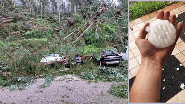
Hailstones and Impacts in Veneto, Italy from the storms of July 19-20 (La Repubblica)
Hailstones form when existing ice particles collide with supercooled liquid water within a thunderstorm. As the hailstones are repeatedly lifted and dropped by updrafts within the storm clouds, water collects and freezes on the hailstones, and they grow. When the hailstones become too heavy to be suspended aloft by the storm updraft, they will fall to the ground, partially melting as they pass through warmer layers of the atmosphere. Larger hailstones can also form by collisions of two smaller hailstones, which create odd, nonspherical shapes sometimes observed.
No additional ALERTs are currently planned for this event. Please contact your Verisk representative if you have additional questions regarding the impacts of these storms, and click here to learn more about Verisk’s Severe Thunderstorm Model for Europe.