
May 16-19 U.S. Derecho Events
Status: Closed
| Type of posting | Posting date(EST): | Summary | Downloads |
|---|---|---|---|
| Event Summary | 5/20/2024 12:00:00 PM |
|
Event Summary | Summary
Posting Date: May 20, 2024, 12:00:00 PM
Two significant derecho events in three days have caused significant damage across several central and southern U.S. states. The first of these events took place Thursday night, as wind gusts estimated at 100 miles per hour by the National Weather Service tore through parts of downtown Houston, knocking windows out of high-rise buildings and causing the collapse of at least one masonry structure. The strongest wind gust recorded in the Houston metro area was 78 mph in the Highlands neighborhood, but damage-based estimates of the wind were closer to 100 mph downtown and estimated at 90-100mph in Baytown. More than one million customers lost power, and as of Monday morning, more than 200,000 customers still did not have power restored in Harris County, per poweroutage.us. Seven people were killed in the storms Thursday evening, which also featured a series of tornadoes, including an EF-1 that impacted Romeville, Louisiana.

Damage to a high rise building in Houston (National Weather Service)
A second event on Sunday plowed through a 430-mile swath across Kansas, Oklahoma, and western Missouri, featuring triple digit wind gusts and up to baseball sized hail. The airport in Salina, Kansas had the highest observed winds, with a reported gust touching 100 mph. A gust of 90 mph was reported in Fowler, KS, and widespread hurricane force gusts were felt across the Wichita, KS metro area. Ellis, KS reported 3-inch hail in this event, while reports of 2.5-inch hail came in from Russell, KS. At least four people were injured, and dozens of buildings reported damaged across Oklahoma as well.
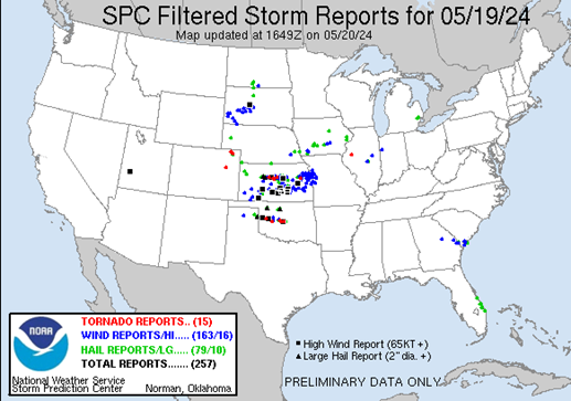
Storm Reports for May 19, 2024 (National Weather Service)
The National Weather Service defines a derecho as a widespread, long-lived windstorm associated with a band of rapidly moving showers or thunderstorms, if wind damage extends more than 240 miles and includes wind gusts of at least 58 mph or greater along most of the length.
Near real-time footprints for hail, straight-line wind, and tornado perils are available through Verisk Weather Solutions Respond analytics. Please contact your Verisk representative with any additional questions regarding Respond analytics or this event. No additional ALERTs are planned for these events at this time.