
May 14-20 U.S. Outbreaks
Status: Closed
| Type of posting | Posting date(EST): | Summary | Downloads |
|---|---|---|---|
| Summary | 5/22/2025 10:00:00 AM |
|
Summary | Summary
Posting Date: May 22, 2025, 10:00:00 AM
A series of severe thunderstorm outbreaks have battered large parts of the central, midwest, and southeast U.S. over the past week. Between May 14 and 20, the National Weather Service Storm Prediction Center received nearly 4,000 reports across hail, straight-line wind, and tornado perils, including dozens of reports of hail greater than three inches and multiple catastrophic tornadoes.
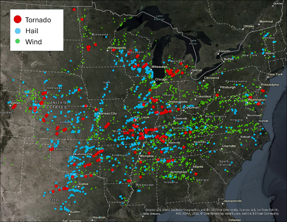
National Weather Service Storm Prediction Center Reports from May 14-20 (SPC/Verisk)
The first outbreak started in the upper Midwest, as a strong cyclone moved across the region on May 15th. This cyclone allowed for warm, moist air to be brought northward from the Gulf into much of the Midwest. The atmosphere became strongly unstable on the 15th across Illinois, Wisconsin, Michigan, Indiana, and Missouri as temperatures surged into the 90s and dewpoints into the 60s and 70s. The cap broke late afternoon and evening across these states where severe thunderstorms quickly developed. Large hail and strong winds were the main threat with these storms, but a few tornadoes also occurred, especially in Wisconsin where the wind shear was strongest. Major metro areas like Chicago and Milwaukee saw large hail of over 1” and damaging wind gusts of 60 mph and above. There were widespread reports of tree and powerline damage as these storms moved from eastern Illinois and Wisconsin into Michigan by the late evening hours. Northwestern Indiana also saw multiple reports of wind damage to properties. Further south, there were also some storms that moved through southern Missouri and in the St. Louis metro area that brought strong winds as well as large hail.
On the 16th, the extent of the severe weather expanded significantly and stretched from southern areas up into the Midwest and east to the Mid-Atlantic region as the cold frontal boundary pushed towards the east. Warm, moist southerly air from the Gulf continued to fuel these powerful severe thunderstorms during the afternoon and evening hours. Missouri, Texas, Indiana, Illinois, Wisconsin, Michigan, Virginia, Kentucky, Ohio, North Carolina, Pennsylvania, and Maryland all saw damaging winds and large hail. There were also several tornadoes that touched down in southern parts of Missouri, Illinois, Kentucky, and Indiana. A deadly and destructive EF-3 tornado also moved through the St. Louis metro area including the city itself leading to five fatalities and many injuries. Another violent tornado classified as EF-4 in the southern Illinois county of Marion also led to seven injuries and widespread damage.

Track of the St. Louis to Edwardsville EF-3 Tornado (Brad Panovich)
A second storm system developing on the leeward side of the southern Rockies began bringing severe weather to the southern Plains and parts of the south on May 17th. Storms took advantage of warm moist Gulf air as a dry line moved across west Texas. Severe thunderstorms began developing in central and northern Texas as well as a good portion of Oklahoma and Arkansas in the afternoon and evening, bringing damaging winds and large hail to these regions. There was also a tornado in Garvin County, Oklahoma. Some of these storms continued into the early morning hours of the 18th.
Later on May 18th, storm activity continued under a similar setup as warm, moist southerly air from the Gulf continued to move into the southern Plains. Powerful supercell thunderstorms moved through west, central, and northern Texas. A few parts of Oklahoma, Kansas, and Arkansas also saw strong thunderstorms as well. Large hail and damaging winds remained a threat. There were also a few tornadoes reported in central Texas including one in Palo Pinto County that caused four injuries. There were also tornadoes reported near the border of the Texas Panhandle and western Oklahoma, and in western and central Kansas.

Tornado Damage in London, KY (Dillon Gaudet/WTVQ)
The system began to move further east across the Plains on the 19th while storm activity in the southern Plains continued. A strong line of thunderstorms fired up in northern Texas, Kansas, and Oklahoma in the afternoon and trekked east into Arkansas and Missouri in the evening. Large hail remained a significant threat with these storms as well as strong winds that downed trees and powerlines. Tornadoes were also reported in eastern Oklahoma, Kansas, Missouri, and northwestern Arkansas.
On the 20th, additional storms formed ahead of a cold front in eastern Arkansas. The system continued to push eastward across the southeast during the evening and overnight hours. Large hail, damaging winds, and tornadoes were reported in Alabama and Arkansas.
Near real-time footprints for hail, straight-line wind, and tornado perils are available through Verisk Weather Solutions Respond analytics. Please contact your Verisk representative with any additional questions regarding Respond analytics or this series of events.