
Hurricane Bill
Status: Closed
| Type of posting | Posting date(EST): | Summary | Downloads |
|---|---|---|---|
| Pre-Landfall 3 | 8/21/2009 1:00:00 PM |
|
|
| Pre-Landfall 2 | 8/19/2009 10:20:00 AM |
|
|
| Pre-Landfall 1 | 8/17/2009 11:07:00 AM |
|
Pre-Landfall 1 | Summary
Posting Date: August 17, 2009, 11:07:00 AM
Hurricane Bill, the first Atlantic hurricane of 2009, formed early Monday morning after an unusually quiet start to the Atlantic tropical cyclone season. Bill is expected to continue to strengthen, possibly becoming a major hurricane (with sustained winds of over 110 mph) by Wednesday. Meanwhile, Tropical Depression Ana, which had weakened from tropical storm status, is currently moving west-northwest through the Caribbean islands. Ana is forecast to dissipate today and is not expected to pose a threat to the United States. A third system, Tropical Depression Claudette, formed quickly in the Gulf on Sunday morning and made landfall less than 12 hours later at tropical storm strength along the Florida Panhandle. Claudette continues to weaken as it moves northwest over Alabama, bringing heavy rains; it is not expected to cause significant wind or flood damage.
Per the National Hurricane Center’s 11:00 AM EDT advisory today, Hurricane Bill is located 1080 miles east of the Lesser Antilles and is moving west-northwest at a forward speed of 16 mph. According to satellite imagery, Bill does not yet display an eye, but the core of the storm is showing signs of increasing organization and several well defined bands of heavy thunderstorm activity are present. With a minimum central pressure of 977 mb and maximum sustained winds of about 90 mph, Bill’s radius of hurricane force winds extend 30 miles from its center, and tropical storm force winds extend 145 miles.
Wind shear along Bill’s track is expected to be low for the next three days and sea surface temperatures, currently around 27°C (80°F), are warm enough to support continued intensification. The NHC forecasts that Bill will strengthen to a major Category 3 or Category 4 hurricane by Wednesday, but increasing shear thereafter will likely prevent further intensification. The Bermuda high will continue to steer Bill on a northwesterly track for the next several days, after which a major trough of low pressure is expected to curve Bill in an increasingly northern direction. As a result, hurricane force winds should remain well clear of the Caribbean islands.
It is too early to forecast how Bill will impact the east coast, although it is currently not expected to make landfall in the U.S. A more immediate concern is how Bill will affect Bermuda on Saturday, since many models expect Bill to pass within 200 miles of the island.
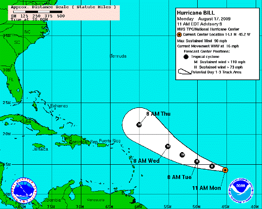
Three Day Track Forecast for Hurricane Bill. (Source: NHC)
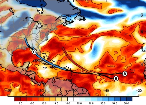
High wind shear, the difference in wind speed at different heights, is destructive to hurricane formation. The absence of strong wind shear in Hurricane Bill’s path is expected to help the storm intensify. (Source: AIR)
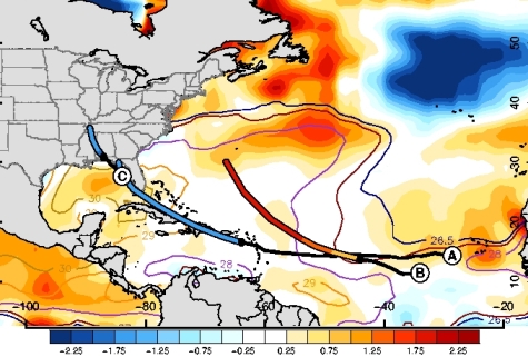
The black line in each storm's path shows where the storm has tracked, while the colored segment following the black line indicates the forecast track, as given by the NHC. Bright orange indicates warmer than usual ocean waters. (Source: AIR)