
Hurricane Bill
Status: Closed
| Type of posting | Posting date(EST): | Summary | Downloads |
|---|---|---|---|
| Pre-Landfall 3 | 8/21/2009 1:00:00 PM |
|
|
| Pre-Landfall 2 | 8/19/2009 10:20:00 AM |
|
|
| Pre-Landfall 1 | 8/17/2009 11:07:00 AM |
|
Pre-Landfall 3 | Summary
Posting Date: August 21, 2009, 1:00:00 PM
Hurricane Bill continues moving northward with Category 3 strength as it is expected to pass between the U.S. East Coast and Bermuda late tonight or early tomorrow. Early morning satellite observations indicated the storm weakened somewhat overnight, its eye becoming barely discernable. In Bermuda, a tropical storm warning and a hurricane watch are in effect, and the island’s government has put troops and emergency services on standby.
In its Friday, August 21, 11:00 am EDT Advisory, the National Hurricane Center (NHC), places Hurricane Bill at about 335 miles (540 kilometers) south of Bermuda and about 755 miles (1215 km) southeast of Cape Hatteras, North Carolina. Bill is moving toward the northwest at nearly 18 miles per hour (30 km/hr) and is expected to make a gradual turn to the north-northwest later today—followed by a return to northward movement tomorrow, Saturday, when it comes in contact with a low pressure trough over the eastern U.S.
At present Hurricane Bill’s maximum sustained winds are near 115 mph (185 km/hr) with higher gusts; its central pressure is 958 mb. Bill is a large storm. Hurricane-force winds extend outward from the center up to 115 miles (185 km), while its tropical force-winds extend as far as 290 miles (465 km). Consequently, even though Bill will only pass by Bermuda, it is expected to cause significant flooding along the island’s coastlines today and tomorrow. Rain has already begun to fall on the island, and total rain accumulations are expected to reach one to three inches, with as much as five inches in some locations. The storm tide is expected to raise water levels by as much as three feet along the coast and to produce large and battering waves.
Similarly, over the next day or two large swells will affect most of the U.S. East Coast, Puerto Rico, Hispaniola, the Bahamas, and eventually the Atlantic Maritime Provinces of Canada. These swells will likely bring what the NHC describes as extremely dangerous surf and life-threatening rip currents. The Dominican Republic’s meteorological service already has reported some coastal flooding along the country’s north coast and damage to roads and houses caused by high waves.
Although Hurricane Bill is now over warm waters and wind shear is low—conditions favorable to storm strengthening—Bill will be moving toward cooler waters over the next 24 hours and is expected to weaken gradually thereafter. While it is unlikely that the U.S. will experience damaging winds, Bill is expected to remain very large and its track is still uncertain. Further north, ExxonMobil Canada has said it is evacuating its workers from production facilities it operates at five natural gas fields off the coast of Nova Scotia. Bill is expected to reach there early Monday.
The figure below shows the tracks of the three named storms in the Atlantic basin this year as of August 21st. The chart beneath the track maps lists the expected number of tropical cyclones— both tropical storms (TS) and hurricanes (HU)—for both the year and this stage of the hurricane season. The final row states the “Accumulated Cyclone Energy,” or seasonal “ACE index value,” which is equal to the collective intensity and duration of Atlantic-named storms and hurricanes that occur during the season. As recently as Tuesday, August 18th, the ACE index for this year stood at just 5.7—well below the expected value for mid-August. Just three days later, the value is actually above average for this stage of the season. The increase is significant and attributable solely to Hurricane Bill’s intensity, size, and duration, in particular at major hurricane strength.
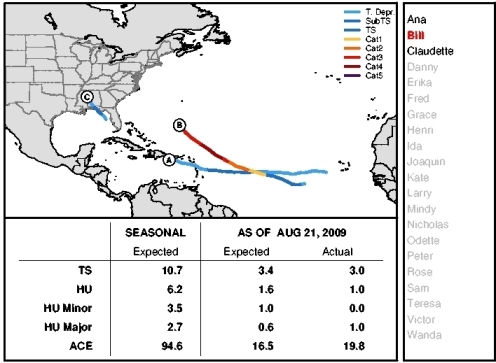
Actual and Expected Tropical Cyclones in the Atlantic Basin as of August 21, 2009 Compared, Including ACE Index Values.
(Source: AIR)