
Tropical Storm Danny
Status: Closed
| Type of posting | Posting date(EST): | Summary | Downloads |
|---|---|---|---|
| Pre-Landfall 2 | 8/28/2009 8:00:00 AM |
|
|
| Pre-Landfall 1 | 8/27/2009 10:00:00 AM |
|
Pre-Landfall 2 | Summary
Posting Date: August 28, 2009, 8:00:00 AM
Tropical Storm Danny continues to struggle with strong wind shear and dry air aloft. Since yesterday’s NewsALERT, the National Hurricane Center (NHC) has reduced its intensity estimate of maximum sustained winds to just 40 mph—barely tropical storm strength. In its satellite image, Danny remains disorganized and there is little in the way of discernable banding. Although there is some renewed convective activity near the storm center, it is not clear that this can be maintained. While there is still a chance of some strengthening during the next 24 hours, the current thinking at the NHC is that Danny will probably not achieve hurricane status. Within 48 hours, Danny is expected to have fully transitioned to an extratropical cyclone.
As of the NHC’s 8:00 a.m. EDT advisory, Tropical Storm Danny is located about 355 miles south of Cape Hatteras, North Carolina, moving to the north-northwest at near 9 mph. A turn to the north and northeast is expected later today. The current NHC forecast track takes Danny close to Cape Hatteras early tomorrow, with an approach toward Massachusetts’ Cape Cod late on Saturday or early Sunday. However, any damaging winds are expected to remain well offshore. While NHC has issued a tropical storm watch for the Outer Banks of North Carolina, they have not done so for Massachusetts. Canada’s Maritime provinces are likely to receive another dose of gusty winds and heavy rain over the weekend and into Monday―only one week after their encounter with Hurricane Bill.
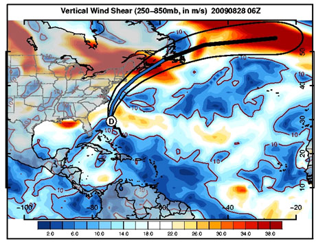
Danny is entering an area of high wind shear. Wind shear—a measure of the difference in wind speed or wind direction between the surface and aloft—can inhibit intensification and rip storms apart. (Source: AIR)