Hurricane Earl
Status: Closed
Pre-Landfall 2 | Summary
Posting Date: August 31, 2010, 10:00:00 AM
Hurricane Earl, now a major Category 4 storm with maximum sustained wind speeds of 135 mph, is moving away from Lesser Antilles and Puerto Rico after battering the islands with strong winds and heavy rain. As of the National Hurricane Center's (NHC) 11:00 AM EDT advisory, Earl is located approximately 220 miles northwest of San Juan, Puerto Rico, and approximately 1075 miles southeast of Cape Hatteras, North Carolina. The storm is currently traveling with a forward speed of 14 mph to the west-northwest, with a gradual turn to the northwest expected later today, and a turn to the north and northeast later this week. However, it is important to note that there is still considerable uncertainty in Earl’s track as it approaches the U.S. east coast. The NHC has advised coastal interests from the Carolinas to New England to monitor the progress of the storm.
In a span of less than 10 hours on Monday, Earl strengthened from a Category 2 to a Category 4 hurricane with a well defined central core as it skirted north of the islands of Barbuda, St. Martin and Anguilla, slipping just slightly northwest of the island of Anengada in the British Virgin Islands on Monday afternoon. Bringing strong winds and very heavy rains, with accumulations of 4 to 8 inches, the storm downed trees and power lines, damaged roofs, and flooded low-lying areas throughout the affected region. No casualties have been reported thus far.
As the storm pulls away from the Virgin Islands and Puerto Rico, strong winds are subsiding, but the outer rain bands associated with Earl may continue to cause torrential downpours, with total rainfall accumulations of up 12 inches possible in some isolated areas. The San Juan National Weather Service has issued a flash flood watch for all of Puerto Rico and the U.S. Virgin Islands.
Currently in an environment of near-record sea surface temperatures and low vertical wind shear, Earl is expected to maintain Category 4 status for the next 48 hours. The possibility exists that Earl could strengthen slightly before encountering cooler mid-latitude waters. However, Earl is approaching an environment of dryer air from the north and increased shear from a trough of low pressure from the southwest that could limit further development.
Earl’s hurricane force winds extend 70 miles from the eye of the storm, and tropical storm force winds extend up to 200 miles. The hurricane is forecast to track over the open Atlantic today, passing approximately 150 miles northeast of the Turks and Caicos Islands, where a tropical storm warning is currently in effect. On its current forecast path, Earl should keep well east of the Bahamas.
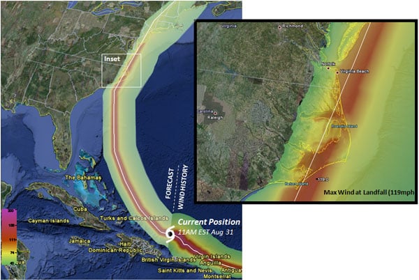
From there, Earl’s track will continue toward the northwest, approaching North Carolina Thursday night and early Friday morning. As it does so, a low pressure system is expected to push out of the Great Lakes, shifting the track to the north and northeast. Earl is then forecast to pass offshore of Cape Cod before making landfall in Nova Scotia Saturday morning at Category 1 strength.
It is important to note that while the forecast models are in general agreement on the track forecast, there is still considerable uncertainty inherent is these predictions. Small deviations in track over the next day could lead to changes in the outlook, and a U.S. landfall for Earl remains a possibility. Based on historical climatology, storms in the vicinity of Earl’s present location have posed a significant threat to the U.S.
Indeed, the left-most path in the NHC’s cone of uncertainty has Earl clipping the Outer Banks barrier islands of North Carolina as a major hurricane before gradually weakening as it moves along the eastern seaboard. On this path, Earl crosses into New Jersey, Connecticut and eastern Massachusetts. The map below shows AIR modeled surface wind speeds associated with this potential track on the extreme west end of the NHC forecast’s cone of uncertainty.

uncertainty at 11:00 AM EDT