
Hurricane Irene (U.S.)
Status: Closed
| Type of posting | Posting date(EST): | Summary | Downloads |
|---|---|---|---|
| Post Landfall 2 | 8/29/2011 1:45:00 PM |
|
|
| Post Landfall 1 | 8/28/2011 9:00:00 AM |
|
|
| Landfall | 8/27/2011 11:30:00 AM |
|
|
| Pre-Landfall 5 | 8/26/2011 11:00:00 AM |
|
|
| Pre-Landfall 4 | 8/25/2011 9:30:00 AM |
|
|
| Pre-Landfall 3 | 8/24/2011 7:15:00 AM |
|
|
| Pre-Landfall 2 | 8/23/2011 10:00:00 AM |
|
|
| Pre-Landfall 1 | 8/22/2011 11:00:00 AM |
|
Post Landfall 2 | Summary
Posting Date: August 29, 2011, 1:45:00 PM
AIR estimates that insured losses from Hurricane Irene to onshore properties in the U.S. will be between USD 3 billion and USD 6 billion. However, there remains uncertainty with respect to the actual parameters of this storm and its impacts; the 90% confidence interval ranges from USD 2.3 billion to USD 7.2 billion.
The still wide range in loss estimates reflected in the 90% confidence interval for this posting is attributable to several factors, including actual storm surge depths, the radius of maximum winds, and the transfer of winds to the surface from aloft, as discussed below. The scenarios reflect the final NHC track.
- High Loss Scenarios: The high end of the range reflects higher storm surge depths, a slightly more intense storm and a larger radius of maximum winds.
- Low Loss Scenarios: The low end of the range reflects lower storm surge depths, a less intense storm and a smaller radius of winds.
- Sources of Significant Uncertainty: Actual surface-level winds are still uncertain. Although the National Hurricane Center reported 85 mph winds at first landfall in North Carolina and 75 mph winds at second landfall in New Jersey, there have been no actual reported sustained wind measurements from onshore stations greater than tropical storm strength. Another question is the extent of leakage of flood damage into wind damage claims. The effect of mandatory evacuations on ALE losses is also uncertain.
AIR estimates include wind and storm surge damage to onshore residential, commercial and industrial properties and their contents, automobiles, and time element coverage (additional living expenses for residential properties and business interruption for commercial properties).
Storm Conditions
After battering the East Coast over the weekend, Irene weakened considerably on its way toward the Canadian border. The storm has transitioned to an extratropical storm system, having become absorbed in a large frontal system. The last National Hurricane Center (NHC) advisory on Irene was posted at 11:00 p.m. last night, August 28. Irene first made U.S. landfall Saturday morning in North Carolina as a Category 1 hurricane, then paralleled the East Coast, and slammed into Little Egg Inlet, New Jersey on Sunday morning as a weakened storm, but still at Category 1 status as reported by the NHC. Irene made a third landfall on Coney Island, NY, at tropical storm strength a few hours later. It should be noted that while the NHC was reporting sustained winds of 85 miles an hour in North Carolina on Saturday, onshore instruments (anemometers) were reporting sustained winds only in the 50- to 60-mile-an-hour range. A similar disparity was observed along the length of the East Coast. Thus it appears that the winds aloft were not being transferred efficiently to the surface. The final range of loss estimates issued by AIR for Hurricane Irene reflects the still-present uncertainty in surface-level wind speeds. Irene brought more than a foot of rain to some parts of the Atlantic coast from North Carolina to Maine, and flooding remains a concern; officials continue to closely monitor river levels, which are receding slowly. Along the Atlantic coast and into New England, the flooding was exacerbated by record or near-record rainfall in August, which created wet soil conditions and had raised water levels in major rivers. Many rivers and streams have overtopped their banks and will remain high as runoff continues. At least 10 rivers or creeks are at or above record flood levels, with most centered over eastern New York and Vermont. Vermont is experiencing its worst flooding in a century. Two major Vermont rivers—the Otter Creek and the Winooski River—are both at the highest flooding levels ever recorded after 3-7 inches of rain fell in just twelve hours. At the Otter Creek gauging station in Rutland, Vermont, water levels rose to over 17 feet—11 feet above flood stage and nearly 4 feet above the previous historical record. The Winooski River is expected to crest at near 20 feet later this evening.Reported Impacts
Hurricane Irene affected nearly 65 million people across 10 states. Thirty-two fatalities have now been linked to the storm. Cleanup crews began clearing roads and restoring electricity to some of the 6 million people that had been left without power. Officials have reported that some of the areas hardest hit by the storm would not have power restored for weeks. The storm also caused school cancellations—many of which had just resumed classes last week—and major highway and interstate closures. This will have a significant impact on business interruption losses. In an unprecedented move, public officials enforced mandatory evacuations of low-lying areas of numerous metropolitan areas. More than two million people were ordered to evacuate—the largest evacuation since Hurricane Frances. This could have a significant impact on insurance losses from Additional Living Expenses (ALE), particularly in the Northeast where the cost of hotels and living expenses are higher. Although mandatory evacuation is not always covered in homeowners insurance policies, these losses are often paid for reasons of good will. Mass transit in several cities was also shut down. In New York, flooding, debris on tracks, and power outages impacted the transit systems. Airlines also canceled more than 12,500 flights, including 1,300 on Monday. Today, most airlines and transit systems have resumed operations; however some Amtrak service along the northeast corridor has not yet been restored. States of emergency were declared for North Carolina, Virginia, Maryland, Delaware, Pennsylvania, New Jersey, New York, Connecticut Rhode Island, and Massachusetts and the National Guard was called out to help rescue people stranded from flooding. Vermont has been declared a federal disaster area. In North Carolina, the storm surge produced beach erosion along the Outer Banks. More than 200 roads and 20 bridges were closed because of downed trees and flooding. Highway 12, the main artery connecting the Outer Banks to the mainland, was left impassable by water and shifting sands. Officials estimate that swells from the Neuse River destroyed at least 25 houses in one neighborhood. In Philadelphia, seven poorly-constructed residential structures are reported to have been destroyed and a roof was torn off a six-story apartment building. Streets were littered with tree branches and other debris. Officials have reported broken windows, siding and roofing materials blown off houses. In New York City, city officials had been worried that the arrival of Irene would coincide with a high tide and potentially inundate the flood defenses of lower Manhattan. Fortunately, only minor flooding occurred and it receded quickly. In Connecticut, twenty homes on Long Island Sound were destroyed by storm surge and high waves. Vermont has been particularly hard hit by river flooding. Several area bridges were washed away or were closed due to eroding banks. Officials at one point thought they might have to flood the state capital, Montpelier, to relieve pressure on a dam, but by Monday morning that threat had abated. Across the New England and the mid-Atlantic, there was widespread tree damage and many roads remain impassable as a result of fallen tree limbs and power lines. Compounding the situation were soils already saturated by earlier heavy rains.
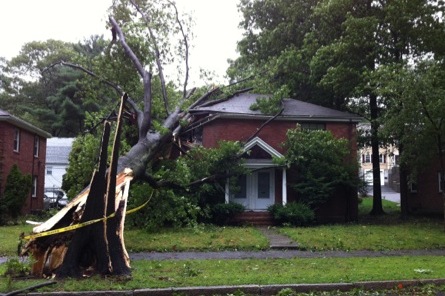
Figure 1: Home in Jamaica Plain, Massachusetts Damaged by a Toppled Tree (Source: AIR).
Note that this will be AIR’s final loss posting for Hurricane Irene.