Tropical Storm Talas
Status: Closed
| Type of posting | Posting date(EST): | Summary | Downloads |
|---|---|---|---|
| Landfall | 9/7/2011 11:45:00 AM |
|
|
| Pre-Landfall 2 | 9/2/2011 1:45:00 PM |
|
|
| Pre-Landfall 1 | 9/1/2011 11:30:00 AM |
|
Pre-Landfall 1 | Summary
Posting Date: September 1, 2011, 11:30:00 AM
Current Situation
Typhoon Talas formed on August 25 as the Japan Meteorological Agency’s (JMA) 12th named storm of the 2011 Northwest Pacific typhoon season. As of the JMA’s 15:40 UTC advisory, the typhoon is located approximately 550 km south of Osaka, Japan, moving 12 km/h in a north-northwest direction. Talas is a large storm, with tropical storm force winds extending up to 650 km from its center. Maximum 10-min sustained wind speeds are 120 km/h (with gusts up to 175 km/h), making it a weak Category 1 hurricane on the Saffir-Simpson scale.
Forecast Track and Intensity
The storm is expected to maintain its present slow north-northwest movement toward the south coast of Japan. Little change in intensity is currently forecast prior to landfall, which is expected to occur late Friday or early Saturday, local time. Talas is currently forecast to make landfall on Shikoku Island and then cross into Honshu Island during the day on Saturday, passing close to Kobe, Osaka, and Kyoto. Because of the storm’s large size, the duration of damaging winds will likely be more than 24 hours in many coastal locations.
Talas is then expected to exit into the Sea of Japan, where it will pick up speed as it interacts with an eastward moving trough and recurve towards the northeast as it crests the subtropical ridge, currently located east of Japan. A second landfall is possible on Sunday anywhere from the Primorsky Krai region of far eastern Russia to the west coast of Hokkaido Island.
Flood Hazard
As Talas approaches landfall, Japan’s mountainous coast will enhance precipitation on the north and east sides of the storm, creating flood and landslide hazards. This occurs because as the counterclockwise flow of air comes onshore, it is forced over the mountainous terrain, cooling in its ascent and forming clouds and precipitation. According to Tropical Rainfall Measuring Mission satellites, total accumulated precipitation from the storm is on the order of 200–300 mm currently. With the interaction of the steep coastal mountains, higher rates are expected in those areas, while 200–300 mm is likely in coastal locations.
Talas’s outer rainbands are already beginning to impact coastal Shikoku and Kinki regions with precipitation rates of less than 10 mm/hr along the coast to as high as 25 mm/hr at higher elevations. Associated with these rain bands are coastal 10-minute sustained winds of up to 40 km/hr. Currently, over a dozen prefectures near the landfall location and along the east side of the forecast track have been placed on alert for ground-loosening precipitation.
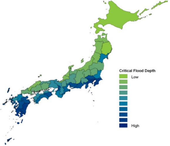
Following devastating inland flood damage from Typhoon Kathleen in 1947 and coastal storm surge damage from Typhoon Vera in 1959, the government of Japan embarked on a massive effort to protect the country against future flood losses. Today, large-scale flood control structures (LFCS) in Japan include dams, embankments, underground cisterns and super levees. Thus, flood risk in Japan depends on both the accumulated runoff (which is a function of precipitation level, topography, and soil conditions) and flood defenses, which vary by region. Taking into account whether actual defenses meet design requirement levels, the map below shows AIR’s assessment of the critical flood depth, or the amount of flooding that the existing defense system can mitigate, throughout Japan.