
Typhoon Roke
Status: Closed
| Type of posting | Posting date(EST): | Summary | Downloads |
|---|---|---|---|
| Post Landfall 2 | 9/22/2011 1:15:00 PM |
|
|
| Post Landfall 1 | 9/21/2011 1:00:00 PM |
|
|
| Pre-Landfall 1 | 9/20/2011 2:00:00 PM |
|
Pre-Landfall 1 | Summary
Posting Date: September 20, 2011, 2:00:00 PM
Current Situation
While still reeling from the effects of Typhoon Talas last month, more than a million people were evacuated in central and western Japan in advance of Typhoon Roke’s arrival. Roke formed on September 10th to become the 15th named storm of the 2011 Northwest Pacific Typhoon Season. The storm is currently being steered around the western boundary of a nearly stationary subtropical ridge. The eye of Roke, which has become less organized over the last few hours, was located about 500 km southwest of Osaka and is moving 16 km/h in a northeastward direction according to the Japan Meteorological Agency’s 1400 UTC advisory.
Typhoon-force winds extend outward up to 80 kilometers from its center, while tropical-storm force winds extend outward up to 260 kilometers. Maximum 1-minute sustained wind speeds are currently 200 km/h, making Roke a Category 3 typhoon. Severe weather warnings are in effect for central and western regions of Honshu.
Forecast Track and Intensity
The storm is expected to accelerate and maintain its present northeastward movement toward Japan’s coast. Roke is projected to slowly weaken as it approaches Japan. Roke is currently forecast to make landfall in central Honshu, about 200 km southwest of Tokyo, and then move northeastward across central Japan on Wednesday. There is some concern that this current path could take the storm towards Japan’s earthquake-devastated Tohoku region, where the damaged Fukushima Daiichi nuclear plant is located. Roke will undergo extratropical transitioning and begin weakening after landfall, and its rapid forward speed should carry the storm across Japan in approximately 12 hours.
Flood Hazard
Last Thursday, Typhoon Roke stalled east of Okinawa, and began a 360-degree loop while continuously tapping into abundant monsoonal moisture from the south. This resulted in moist, onshore flow for eastern Kyushu, Shikoku, and southern Kinki producing more than 1,000 mm of precipitation in the Kyushu mountains, and as much as 400 mm in some of the larger cities, including Miyazaki , Kochi, and Tokushima.
Japan’s mountainous coast will enhance precipitation on the north and east sides of the storm, creating flood and landslide hazards. Additional precipitation is estimated on the order of 200-300 mm in low-lying coastal regions. However, the increased forward speed should limit the most extreme precipitation scenarios. The JMA has warned of flooding and landslide threat in the western prefecture of Wakayama after it was badly affected by Typhoon Talas. The figure below shows the 5-day rainfall accumulation for Japan.
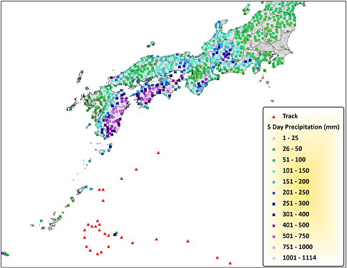 5-day precipitation totals from Typhoon Roke (Source: JMA)