Hurricane Isaac
Status: Closed
| Type of posting | Posting date(EST): | Summary | Downloads |
|---|---|---|---|
| Post Landfall 1 | 8/30/2012 7:30:00 PM |
|
|
| Landfall | 8/29/2012 9:50:00 AM |
|
|
| Pre-Landfall 7 | 8/28/2012 9:00:00 AM |
|
|
| Pre-Landfall 6 | 8/27/2012 1:00:00 PM |
|
|
| Pre-Landfall 5 | 8/26/2012 6:20:00 AM |
|
|
| Pre-Landfall 4 | 8/25/2012 6:45:00 AM |
|
|
| Pre-Landfall 3 | 8/24/2012 10:20:00 AM |
|
|
| Pre-Landfall 2 | 8/23/2012 11:00:00 AM |
|
|
| Pre-Landfall 1 | 8/22/2012 11:20:00 AM |
|
Landfall | Summary
Posting Date: August 29, 2012, 9:50:00 AM
By 7:00 AM CDT this morning (8:00 AM EDT), Isaac had made two separate landfalls, both as a Category 1 hurricane. The first occurred on August 28 at low-lying Plaquemines Parish, Louisiana, at around 7:45 PM CDT. Instead of continuing inland as expected, the storm veered sharply to the southwest and re-emerged over the water, which allowed it to maintain its strength. It then made a second landfall this morning just west of Port Fourchon, Louisiana, at around 2:15 AM CDT.
As of 10:00 AM CDT, the storm is still a Category 1 hurricane with maximum sustained wind speeds of 75 mph. The center of the storm is currently over Houma, southwest of New Orleans, and it is moving NW at 6 mph with a central pressure of 972 mb. In southeastern Louisiana, sustained winds of 40-55 mph have been reported, with gusts as high as 100 mph; a gust of 113 mph was reported in Belle Chasse. The area is being pelted with heavy rains along with gusty winds. Flooding and storm surge warnings are in effect. Heavy flooding has occurred in Plaquemines Parish, where a 9-foot earthen levee was overtopped. The water level at the Jourdan River, near Diamond Head, Mississippi, is expected to reach 9.5 feet over the next 24 hours; the river is currently at a moderate flood level of 8.7 feet.
Reported Impact
Isaac remains a large storm; hurricane force winds extend 60 miles from the center. Storm surge has been exacerbated by the storm’s slow forward speed.
Two levees in sparsely populated Plaquemines Parish were overtopped, but no breaches have been reported. The levees in this region are generally earthen barriers, around nine feet tall and not upgraded since Hurricane Katrina. As a result of the overtopping, flooding is reported across an 18-mile stretch reaching from St. Bernard Parish south to White Ditch. Plaquemines Parish has up to 12 feet of water, and some homes in the Braithwaite area are submerged up to the rooftops. Many residents there are stranded in flooded homes and rescue operations are underway. Elsewhere, a storm surge of up to 12 feet was reported at Shell Beach, Louisiana, and 3-5 feet of flooding has occurred in Biloxi Bay.
In New Orleans, 6-10 inches of rain have fallen. Although some streets in the city have been made impassable by flooding from precipitation and downed trees, the fortified levees have held. Isaac has put to test the massive $14.5 billion flood control system built in the area by the U.S. Army Corps of Engineers in response to Hurricane Katrina. The walls, levees, pumps, and huge floodgates are designed to withstand a Category 3 hurricane, equivalent to Hurricane Katrina whose storm surge breached the levees at the time killing 1,500 people and causing over $80 billion in damage. The system includes upgraded levees, and 73 floodgates in five parishes including a 2-mile floodgate that stands 26 feet high at the upper end of Lake Borgne. This barrier, the largest of its kind in the world, has been closed for the first time since it was built.
High winds and saturated soil have allowed dozens of trees to be blown over causing damage, downed power lines, and road blockage. Some roof damage has been reported with several roofs being torn off homes from strong winds. Most of the businesses in New Orleans are closed and a significant police and military force is in place to maintain safety. Flights to and from New Orleans are cancelled and at least two airlines, United and Southwest, have said they will not resume operating there until Thursday.
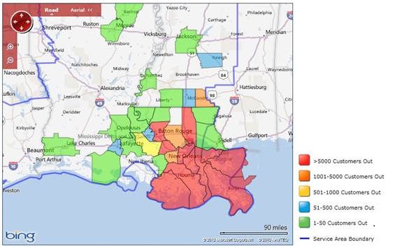
According to several energy companies including Entergy, Alabama Power, and Cleco, over 520,000 homes and businesses in Arkansas, Alabama, Louisiana, and Mississippi are currently experiencing power outages. Most of these outages are in southeastern Louisiana.