
Hurricane Rafael
Status: Closed
| Type of posting | Posting date(EST): | Summary | Downloads |
|---|---|---|---|
| Pre-Landfall 2 | 10/16/2012 9:35:00 PM |
|
|
| Pre-Landfall 1 | 10/15/2012 7:30:00 AM |
|
Pre-Landfall 2 | Summary
Posting Date: October 16, 2012, 9:35:00 PM
Rafael became the season’s 9th hurricane on Monday after tracking through the Leeward Islands. The storm then bypassed Bermuda late Tuesday evening. As of the National Hurricane Center's (NHC) 5:00 AM EDT advisory, the storm remains a Category 1 hurricane with a minimum central pressure of 974 mb and maximum sustained winds of 80 mph. Rafael is currently located approximately 310 miles northeast of Bermuda and is moving to the north-northeast at 33 mph.
The storm’s center passed 110 miles east of Bermuda, buffeting the island with tropical storm-force winds, which extended 200 miles outward. That radius has increased and currently tropical storm-force winds extend up to 275 miles outward while hurricane-force winds extend up to 70 miles outward. Sustained winds at the storm’s center were reported by Hurricane Hunter flights to be as high as 90 mph and were slightly lower at 85 mph when the storm bypassed Bermuda. The storm is expected to turn toward the northeast later today and then east-northeast on Thursday.
Reported Impact
At the Bermuda Airport, maximum sustained winds were 35 mph, with gusts up to 51 mph. Rainfall of 1.65 inches has been reported. Government offices were closed early Tuesday, and the storm has forced some flight and ferry cancellations. Schools and colleges in Bermuda were also closed. The building stock in Bermuda is well-designed for wind resistance and can easily withstand the winds from Hurricane Rafael. Residential buildings are primarily of masonry block construction, with limestone tile roofs. Commercial buildings are mainly of reinforced concrete. Wood-frame structures, which are more vulnerable to wind damage, are not common on the island. Most buildings in Bermuda have colonial shutters on the windows, which provide additional protection from high winds.Forecast and Intensity
With its impressive 275-mile radius of tropical storm-force winds and a 70-mile radius of hurricane-force winds, Rafael is expected to remain a powerful storm over the next few days, but will remain well off the northeastern coast of the U.S. and Canada. The most likely forecast track shows Rafael shifting to the northeast later today and then back to the east-northeast direction. The storm is expected to maintain strong winds of 69 mph with gusts up to 86 mph over the next few days. Bermuda could receive total rainfall amounts of 2 to 4 inches. The storm may continue to produce dangerous swells and rip currents along the Bermuda coast and parts of the eastern U.S. coast. This will be the last communication on Hurricane Rafael.
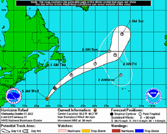
Figure 1: Track Map for Tropical Storm Rafael (Source NOAA).
Tropical Storm Paul
The center of Tropical Storm Paul remains close to the coast of Mexico’s Baja peninsula. As of Tuesday morning, Paul’s maximum winds had weakened to 40 mph. The storm is expected to brush the coast later today as a tropical depression. Given the sparse population in the affected area and low insurance take-up, AIR does not expect significant insured losses from this storm.