Landfall | Summary
Posting Date: October 30, 2012, 2:45:00 PM
AIR estimates an expected (mean) insured industry loss to onshore U.S. property exposures from Sandy (now a tropical depression) of near USD 10 billion, with a likely uncertainty interval of USD 7 billion to USD 15 billion.
- High Loss Scenarios: The high end of the range reflects a more intense storm and a larger radius of maximum winds.
- Low Loss Scenarios: The low end of the range reflects a less intense storm and a smaller radius of maximum winds.
Sources of Significant Uncertainty
The remaining sources of uncertainty with respect to Sandy’s ultimate impact on the industry are numerous; the most significant are listed below:
- Sandy’s extremely large windfield became highly complex when it interacted with another weather system to the west. This interaction slowed the rate of decay of wind speeds inland significantly. Low level losses far from the storm’s center—such as in Virginia, Ohio, and Massachusetts—are not captured. Neither is the damage caused by heavy snowfall in the Appalachians, and indeed it is not clear whether those losses will be attributed to Sandy from an insurance perspective.
- There is also considerable uncertainty with respect to commercial flood insurance take-up rates and policy conditions in the areas affected by Sandy’s record storm surge, and particularly in New York City’s boroughs. AIR assumes a 10% take-up rate for commercial flood policies and this assumption is reflected in the losses above. However, AIR ran sensitivity tests for a variety of assumptions for commercial flood take-up rates. Using a 50% take-up rate, for example, another USD 600 million to USD 1.2 billion was added to the losses reported above.
- The AIR U.S. Hurricane Model considers indirect impacts on Business Interruption (BI) losses based on storm severity. However, the flooding of subways and major highway tunnels is not explicitly modeled. This situation, combined with explosion at Consolidated Edison could result in very high BI losses. However, there is also uncertainty in how BI coverage will be treated in light of the fact that greater New York City has virtually shut down.
- According to the National Hurricane Center’s special landfall advisory issued at 8:00 pm on October 29, Sandy made landfall as a post-tropical cyclone, and not a hurricane. There is, as a result, uncertainty in how carriers will treat deductibles. AIR’s modeled losses reflect the use of a hurricane deductible.
- Finally, uncertainty results from the amount of rainfall that Sandy has produced and may continue to produce during its slow progress inland. Given the heavily saturated soils, trees will be downed by much lower wind speeds than would normally be required.
AIR estimates include wind and storm surge damage to onshore residential, commercial and industrial properties and their contents, automobiles, and time element coverage (additional living expenses for residential properties and business interruption for commercial properties). Further details are provided below:
AIR’s loss estimates reflect:- Insured physical damage to property (residential, commercial, industrial, auto), both structures and their contents;
- Additional living expenses (ALE) for residential claims;
- For residential lines, estimates reflect AIR’s view that insurers will ultimately pay 10% of modeled storm surge damage as wind losses;
- For commercial lines, insured physical damage to structures and contents, and business interruption directly caused by storm surge, assuming a 10% take-up rate for commercial flood policies (Note: Other flood losses are not modeled or reflected in estimates); business interruption losses include direct and indirect losses for insured risks that experience physical loss;
- For the automobile line, estimates reflect AIR’s view that insurers will pay 100% of storm surge damage;
- Demand surge.
Loss estimates do not reflect:- Losses paid out by the National Flood Insurance Program
- Losses resulting from the compromise of existing defenses (e.g., natural and man-made levees);
- Losses from the flooding of tunnels and subways;
- Losses to uninsured properties;
- Losses to infrastructure;
- Low-level losses in states distant to the storm’s center that have resulted from the interaction between Sandy and another frontal system to the west;
- Losses from extra-contractual obligations;
- Losses from hazardous waste cleanup, vandalism or civil commotion whether directly or indirectly caused by the event;
- Other non-modeled losses;
- Losses for U.S. offshore assets and non-U.S. property (AIR estimates these losses separately).
Landfall Conditions
Sandy made landfall as a post-tropical cyclone at around 8:00 p.m. EDT October 29, 2012, 5 miles southwest of Atlantic City, NJ. At landfall, the storm had a central pressure reading of 946 mb and estimated sustained winds of 80 mph. Actual wind recordings included gust wind speeds of 90 mph in Islip, NY, and Tompkinsville, NJ. Other readings included gusts of 84 mph at Plum Island, NY, 83 mph in Cuttyhunk, MA, and 76 mph in Groton, CT.
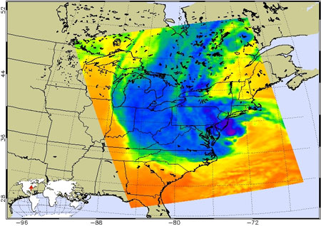
Hours before landfall, Sandy’s central pressure reached a low of 940 mb—a pressure reading that would usually be associated with more powerful hurricanes—but it remained a Category 1 storm. This was due to Sandy’s enormous size; tropical storm-force winds reached nearly 950 miles across, and hurricane-force winds extended 175 miles from the center. This allowed for a more gradual wind speed gradient between the eye and the outer bands, which mitigated the wind speed. Sandy’s diameter made it the largest Atlantic hurricane on record in terms of the span of tropical storm-force winds. The storm affected areas as far north as Toronto and west to the Great Lakes. Chicago reported wind gusts up to 60 mph and waves in Lake Michigan exceeded 24 feet.
Sandy’s diameter was nearly twice the size of other massive hurricanes including Katrina (2005) whose diameter was 435 miles, Isabel (2003) whose diameter was 575 miles, and Isaac (2012) whose diameter was 450 miles. The huge radius helped to keep the winds at Category 1 intensity and allowed the storm to interact with an approaching disturbance in the jet stream that resulted in severe weather across a wide swath of the eastern United States, including blizzard conditions in the higher elevations of the Appalachians.
 Figure 1. Infrared image of Hurricane Sandy at 2:17 p.m. EDT on October 29 shows the storm's geographic extent. (Source: NASA)
Current and Forecast Conditions
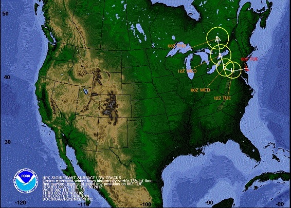
As of 11:00 AM EDT on Tuesday, October 30, Sandy is still a post-tropical cyclone with maximum sustained wind speeds of 45 mph, a decrease from the 65 mph speed reported earlier this morning. The center of the storm is about 145 miles west of Philadelphia and is moving west at 10 mph. The storm is expected to move across southern Pennsylvania and turn north into western New York State later tonight. By Wednesday, the storm’s center is expected to reach Canada.
 Figure 2. Track for Post-Tropical Cyclone Sandy (Source: NOAA)
Strong, gusty winds are forecast to continue until this afternoon over the northeast and parts of Appalachia, as well as around the Great Lakes. Rainfall of 4 to 8 inches is expected over parts of the Atlantic states including the Delmarva Peninsula, with up to 12 inches possible in isolated areas; 3 to 6 inches are expected over northeastern NC, with up to 8 inches possible in isolated areas, and 5 inches are possible along the coast from New York State to New England. While surge levels have subsided, additional flooding is still possible.
Sandy’s circulation drew in frigid air from Canada. As a result, 2 to 3 feet of snow are expected in the higher elevations of West Virginia, while 1 to 2 feet are expected in southwestern Virginia. About a foot or more of snow is predicted to fall in the mountains of western Maryland and along the North Carolina-Tennessee border.
Reported Impacts
Sandy has brought New York City and other major cities along the Atlantic coast to a halt, and has claimed at least 18 lives. President Obama has declared New York and New Jersey as disaster areas while declaring states of emergency in most of the other affected states.
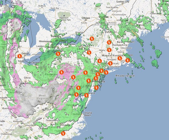
A record storm surge (13.88 feet at the Battery in lower Manhattan) produced significant flooding particularly in the low-lying areas near the East River and several towns on the Jersey Shore. An explosion at Consolidated Edison, along with countless downed power lines, has left over 670,000 customers in the New York City area without power. At the storm’s peak, an estimated 7 million people were without power across 10 states.
The Brooklyn-Battery tunnel and seven subway tunnels under the East River remain flooded, and commuter rail service is suspended, effectively shuttering business in New York City. Officials have suggested that it will take several days before transportation is restored. The stock exchange remains closed as do other businesses along with schools and theaters. Travel in the city remains treacherous as shattered glass and downed power lines litter the streets. On West 57th street, a crane atop an 80-story building under construction was damaged leaving its boom dangling treacherously above the ground.
Along the entire east coast and well inland, heavy rainfall softened the soils allowing trees to be loosened and topple more easily onto homes, cars and power lines. Subways were shut down in all major cities from Boston to Washington, D.C. Downed power lines sparked fires that destroyed homes in the New York City area, including 50 homes in Queens. In addition to flooded streets and downed trees blocking the routes, firefighters had to deal with low water pressure making it even more difficult to fight the fires.
 Figure 3. Power outages caused by Post-Tropical Cyclone Sandy (Source: Google Maps)
In New Jersey, an overtopped natural levee forced an evacuation of the towns of Moonachie, Little Ferry, and Carlstadt. Hundreds of residents are still being rescued today. Moonachie’s fire department, police department, and municipal building have been destroyed. Over two million in New Jersey are still without power. In Massachusetts, most of the damage was limited to the coastal areas although downed trees and power lines were seen across the state. Some 300,000 homes remain without power today.
Sandy also shuttered the nation’s capital. The National Weather Service predicted the worst flooding of that region since 1996. High wind warnings extend across Washington, Virginia, and Maryland, which are all in declared states of emergency. Dominion Power has reported about one million are without power and fires have also broken out due to down power lines.
 Figure 1. Infrared image of Hurricane Sandy at 2:17 p.m. EDT on October 29 shows the storm's geographic extent. (Source: NASA)
 Figure 2. Track for Post-Tropical Cyclone Sandy (Source: NOAA)
 Figure 3. Power outages caused by Post-Tropical Cyclone Sandy (Source: Google Maps)