Pre-Landfall 2 | Summary
Posting Date: October 25, 2012, 12:00:00 PM
Current Conditions
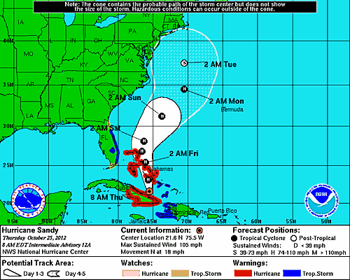
With maximum sustained winds of 105 mph, Sandy is now a Category 2 hurricane on the Saffir-Simpson Hurricane Wind Scale, up from tropical storm strength at this time yesterday but diminished in strength since its landfall in Cuba late last night. As of the National Hurricane Center (NHC) Advisory at 8 a.m. (EDT) this morning, the storm is off the northeast coast of Cuba in open waters, about 130 miles south of Great Exuma in the Central Bahamas. It is forecast to make a pass through the Central Bahamas late afternoon today, local time, still at hurricane strength. Sandy is currently moving north with a forward speed of 18 mph.
Reported Damage
Sandy approached Jamaica yesterday morning as a tropical storm. Conditions in the Caribbean were favorable for intensification, however, and Sandy’s wind speeds reached 80 mph (Category 1 strength) before it made landfall near Kingston on the southeastern coast of the island yesterday afternoon.
Sandy’s wind and rain knocked out power to 70% of the island and canceled cruises and flights. High winds also blew roofs off some houses, and roads were made impassable as a result of fallen trees and flooding. So far, however, damage reports indicate that flooding has done the most substantial damage. Sandy’s landfall in Jamaica was the first landfall on the island since Hurricane Gilbert in 1988.
After exiting Jamaica yesterday afternoon, Sandy rapidly intensified on its northward route toward Cuba, reaching Category 2 status just before making landfall late last night on Cuba’s southeastern coast, about 5 miles west of Santiago de Cuba, the country’s second largest city. Wind speeds at landfall were 110 mph. The eastern provinces of Granma, Holguin, and Las Tunas were hardest hit; some 5,000 tourists at beach resorts in Holguin were evacuated ahead of the storm, along with 10,200 residents. Prior to the storm’s arrival, the Cuban government also evacuated 450 tourists from beach resorts near the city of Santiago de Cuba.
Although the storm passed well west of the U.S. naval base at Cuba's Guantanamo Bay, it knocked out power to many of the 5,500 residents there. Sandy also ripped the roofs off homes, damaged fragile coffee and tomato crops, and knocked palm trees and telephone poles into roads, disrupting traffic for commuters today. Preliminary reports from a local Cuban radio station indicate that numerous homes and hotels in the municipality of Palma Soriano (in the province of Santiago de Cuba) were severely damaged. Some collapsed. One early report indicates that the number of homes damaged in the province was 3,000. Among these are likely to be older, poorly maintained structures, which are more vulnerable to severe structural damage; these structures are less likely to be insured though. The storm caused widespread power outages in Santiago de Cuba as well. As in Jamaica, flooding was a substantial threat to local exposure. As on other islands in this region, heavy rain can cause life-threatening flash floods and mudslides in Cuba, particularly in regions of the country with mountainous terrain. Cuba’s civil defense minister indicated that the results of heavy rain could affect up to 20,000 people in the country.
Though hurricane conditions will gradually lessen over eastern Cuba today, a hurricane warning remains in effect for the Cuban provinces of Camaguey, Las Tunas, Granma, Santiago de Cuba, Holguin, and Guantanamo.
On its current path, Sandy is projected to weaken slightly as it approaches the Bahamas, though it will still be a hurricane when the storm center arrives there later this afternoon. Hurricane-force winds extend outward up to 25 miles and tropical storm-force winds extend outward up to 140 miles. Hurricane conditions are expected to spread across the central and northwestern Bahamas prior to landfall and to persist through Friday. A hurricane warning is in effect for all of the Bahamas, apart from the Southeastern Bahamas, where a tropical storm warning is in effect. Elsewhere, a tropical storm warning is in effect for Haiti, Florida’s east coast from Ocean Reef to Flagler Beach, and Lake Okeechobee, Florida.

Figure 1: Track Map for Hurricane Sandy (Source: NOAA).
Exposure at Risk
In Cuba and Jamaica, the full damage picture from Hurricane Sandy is still emerging. In Jamaica, most buildings in the major urban areas such as Kingston are constructed of brick or reinforced concrete with tiled or cement roofs. If these buildings are well-constructed, they should not suffer much damage from the wind speeds Sandy delivered yesterday. These winds could, however, test vulnerable roof materials such as light metal; in fact, damage reports from Jamaica have indicated this kind of roof damage has occurred. While Sandy’s projected wind speeds do not represent a significant threat to most Jamaican construction, damage due to flooding is an additional hazard. Weaker construction types such as timber or unreinforced masonry are most vulnerable to the heavy rain Sandy delivered yesterday. Contents are also at risk if walls made from these materials are compromised by flooding.
To the north, in Cuba, residential structures are predominantly masonry, with wood frame representing a small part of the building stock. A large number of structures in Cuba are very old, and investments to maintain building quality have not been made. Commercial or tourism-related buildings have likely been given more attention over time and are better equipped to handle wind and flood hazards, but older residential structures will be less robust. In light of the rainfall and flooding from Sandy, some of these poorly maintained structures in Cuba may have experienced damage to contents or structural walls due to breach of the building envelope. At Sandy’s wind speeds (strong Category 2), non-engineered residential structures may have been vulnerable to roof or building envelope damage. In particular, wooden or metal roof types would be most susceptible, especially for older structures where maintenance or strong connections may be lacking. Indeed, the roofs were reportedly ripped off several homes in Cuba as Sandy passed through the country. Water infiltration is also an elevated concern for older buildings in Cuba.
Farther north still, the Bahamas have very stringent and highly enforced building codes. This will help limit severe structural damage to a certain extent. Houses in the Bahamas are typically constructed using concrete block or poured concrete, although unreinforced masonry and timber construction are also used. Most residential dwellings are single story, while commercial buildings can be mid- or high-rise. At Category 2 wind speeds, non-engineered structures can experience damage to roof and wall claddings. This type of damage is likely to affect many homes with shingle roofing, but is unlikely to be significant, in most cases. Engineered structures may sustain nonstructural damage such as window and roof covering damage. Meanwhile, business interruption losses could occur from both direct physical damage to hotels and resorts, as well as damage to supporting utilities. The greatest threat in the Bahamas, however, will likely be from flooding, which can cause significant damage to low-rise structures. (Currently, the NHC predicts storm surge between 5 and 8 feet in the central and northwestern Bahamas.) There can also be significant damage to signage, traffic lights, trees, etc., at Sandy’s projected wind speeds.
Forecast Track and Intensity
Sandy’s current movement north at 18 mph is expected to continue today as the storm approaches the central Bahamas, though a turn toward the north-northwest and a decrease in forward speed are expected tonight. Hurricane Sandy is also predicted to gradually weaken over the next several hours, though it will still be at hurricane strength by the time it moves near or over the Bahamas later today and tonight. Tomorrow, Friday, Sandy is forecast to move near or over the northwestern Bahamas.
In all, Sandy is forecast to produce 6-12 inches of rain (with isolated maximum rainfall of 20 inches also possible in some locations) across Haiti, the Dominican Republic and Eastern Cuba. The NHC cautions that this large amount of rain may cause life-threatening flash floods and mudslides, particularly in regions with mountainous terrain. Smaller amounts of rain – between 3 and 6 inches – are predicted to fall over parts of the Bahamas, though up to 12 inches of rain may occur in some isolated parts of these islands. Storm surge between 5 and 8 feet in height could also impact the central and northwestern Bahamas. Across the Florida Keys into southeast and east central Florida, 1 to 3 inches of rain are possible.
Although all the computer models agree that Sandy will move into the Bahamas through Friday, they diverge after that. Some models forecast that Sandy will move out into the ocean and away from the U.S. coastline, while others predict that the storm will curve sharply to the west and possibly impact the Northeastern U.S early next week. If it makes landfall in the Northeastern U.S., the system will be a post-tropical cyclone, though some models are now saying there is a chance that some tropical characteristics will still be present and winds may be as strong as 70 mph. Sea surface temperatures off the New England coast are about 5 degrees Fahrenheit above normal. Accordingly, if Sandy does strike the U.S. early next week, the storm will be able to draw energy from the warm ocean waters and its radius will be extremely large. A full moon will enhance the flood risk at high tide.
It should be emphasized that there remains considerable uncertainty around Sandy’s projected path once it exits the Bahamas. In an effort to increase forecast accuracy, the National Weather Service has asked all airports across the entire U.S. to launch extra weather balloons. AIR’s Tropical Cyclone team will continue to monitor Sandy closely during the next few days and will post additional information on the development and impacts of this storm.
Far out in the Atlantic, the season's 19th named storm, (tying 2010 and 2011 for the third most storms in recorded history), Tropical Storm Tony, which formed Tuesday night, has weakened (45 mph maximum sustained winds) and poses no threat to land.
