Post Tropical Cyclone Sandy
Status: Closed
Pre-Landfall 5 | Summary
Posting Date: October 29, 2012, 2:00:00 PM
Current Situation
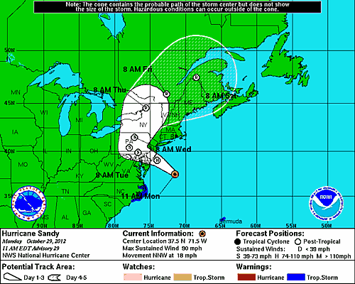
As forecast, Hurricane Sandy intensified overnight and its path began to turn toward the U.S. East Coast. As of 11 a.m. EDT, Sandy has maximum sustained winds of 90 mph and is moving north-northwest at 18 mph. Central pressure is now 943 mb. The storm’s current location is about 205 miles southeast of Atlantic City, N.J., and about 260 miles south-southeast of New York City.
Although the NHC’s latest advisory indicates that Sandy’s sustained winds have achieved 90 mph, some weakening is likely to occur before landfall tonight and Sandy is expected to arrive on the south Jersey shore with winds of about 75 mph. As indicated in the National Hurricane Center (NHC) wind extent map, the impacts of tropical storm force winds have already been felt on the East Coast. The storm has impacted barrier islands off North Carolina, making several homes and businesses almost inaccessible. A tall ship with 16 people aboard was in distress 90 miles off the coast.
Later today, wind and surge will become more significant from Long Island Sound to Chesapeake Bay, with some of the strongest impacts being felt this evening, prior to the actual storm landfall. One caveat regarding the interpretation of the NHC track maps is that as Hurricane Sandy gets closer to landfall, the extent of the cone is decreasing. This reflects the increased forecast certainty in the track and is not an indication of the extent of damaging winds. For example, while New York City is not actually in the NHC cone any more, that does not mean they will not be impacted strongly by this event.
The NHC track forecast is still largely unchanged, and the intensity forecast is still calling for Hurricane Sandy to have hurricane force wind speeds as it makes landfall close to midnight tonight. The highest wind speeds will most likely be experienced along coastal exposures, where winds have less interaction with land and thus experience less surface friction. However, the associated area of damaging winds will be more uniform and more widespread than with a typical tropical cyclone (and extend farther inland), due to the transition of the storm to an extratropical cyclone system.
The NHC track forecast projects landfall a little farther south along the New Jersey coast than yesterday. This is a subtle change and does not alter the overall expectations regarding the storm’s impacts. NHC also forecast the storm system to slow down after landfall, so it will linger over Pennsylvania longer than it was expected to yesterday. However, the greatest remaining uncertainty in the system revolves around what happens in the days after landfall. The storm’s impacts will diminish over that time, but some tropical storm force winds could linger in Washington, D.C., Philadelphia, and New York City well into Wednesday night.
 Track Map for Hurricane Sandy (Source: NOAA)