Tropical Storm Ernesto
Status: Closed
| Type of posting | Posting date(EST): | Summary | Downloads |
|---|---|---|---|
| Post Landfall 1 | 8/10/2012 7:45:00 AM |
|
|
| Landfall | 8/8/2012 11:00:00 AM |
|
|
| Pre-Landfall 3 | 8/7/2012 11:30:00 AM |
|
|
| Pre-Landfall 2 | 8/6/2012 1:00:00 PM |
|
|
| Pre-Landfall 1 | 8/3/2012 10:00:00 AM |
|
Post Landfall 1 | Summary
Posting Date: August 10, 2012, 7:45:00 AM
Tropical Storm Ernesto made its second landfall on Thursday, August 9th at around 1:00 PM CDT in the southern part of the Mexican state of Veracruz. Wind damage is expected to be minimal, but the storm’s heavy rainfall is expected to continue throughout the day, even as the system dissipates. The states of Veracruz, Tabasco, Puebla, Oaxaca, and Guerrero are on alert for flooding and landslides.
Meteorological History
Ernesto made its first landfall in Quintana Roo late Tuesday night local time at Category 1 hurricane strength (with maximum sustained winds of approximately 85 mph). The storm then weakened as it tracked across the Yucatan peninsula, re-emerging into the Bay of Campeche during the day on Wednesday. Back over water, Ernesto drew warm maritime air back into the system, which significantly increased the thunderstorm activity around the center of circulation. As a result, maximum sustained winds increased to approximately 70 mph (strong tropical storm) and the minimum central pressure dropped to an estimated 993 mb.
Ernesto tracked along the coast of southern Veracruz state before coming ashore just west of the port city of Coatzacoalcos around 1:00 PM CDT (18:00 UTC) on Thursday. Maximum sustained winds at second landfall were around 60 mph. The storm decayed rapidly as it moved over land and interacted with mountainous terrain of southern Mexico. As of the National Hurricane Center’s 4 AM CDT advisory today, Tropical Depression Ernesto had maximum sustained wind speeds of 35 mph and is located in southern Puebla. It is forecast to continue weakening and is expected to dissipate by early this afternoon over the state of Guerrero.
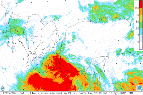
Precipitation Analysis
The interaction of the storm with mountainous terrain in the interior of Mexico is producing heavy precipitation over much of central and southern portions of the country. As the remnants of Ernesto continue to track west, the storm continues to have the potential to cause heavy rainfall and flooding. Some mountainous areas in the states of Veracruz, Tabasco, Puebla and Oaxaca could receive isolated rainfalls amounts of up to 15 inches. The city of Coatzacoalcos received more than seven inches of rain prior to Ernesto's landfall, and San Pedro reported more than 10 inches, according to the Mexican weather service. The map below shows 24-hour total rainfall accumulation in millimeters (25 mm = 1 inch) up to 12:00 UTC today.