Typhoon Jelawat
Status: Closed
| Type of posting | Posting date(EST): | Summary | Downloads |
|---|---|---|---|
| Post Landfall 1 | 10/1/2012 1:30:00 PM |
|
|
| Landfall | 9/30/2012 9:30:00 AM |
|
|
| Pre-Landfall 1 | 9/28/2012 10:45:00 AM |
|
Post Landfall 1 | Summary
Posting Date: October 1, 2012, 1:30:00 PM
Current Conditions
After passing over Japan’s main island of Honshu yesterday as a weakening tropical cyclone, the remnants of Typhoon Jelawat are currently over the Northwest Pacific Ocean, racing away from Japan at about 85 km/h. According to the 12:00 UTC (8:00 am EDT) Advisory from the Japan Meteorological Agency (JMA), Jelawat is about 900 kilometers from Hokkaido and is passing more or less parallel to Russia’s Kuril Islands south of the Kamchatka Peninsula. As Jelawat no longer is a tropical storm, the JMA will not be continuing to update its status. Typhoon Jelawat made landfall on Honshu yesterday morning local time, September 30, in southern Wagayama prefecture, and moved quickly inland. By early Monday morning local time, Jelawat was over the Tohoku region of northwestern Honshu, about to return to the ocean. This was the region devastated by the March 2011 Tohoku earthquake and tsunami.Reported Impacts
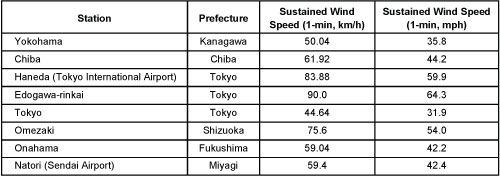
Yesterday, Sunday, the city of Nagoya issued an evacuation advisory to more than 50,000 residents, anticipating possible flooding from swollen rivers. A similar advisory was issued for more than 10,000 people in Ishinomaki, Tohoku, in the north. Other local governments, according to news reports, also issued evacuation advisories. In the mountains of Shizuoka Prefecture, west of Tokyo, more than six inches of rain fell in less than six hours. The cities of Fujinomiya and Hamamatsu in that prefecture received 120 millimeters of rain an hour (4.75 inches), prompting the JMA to issue an alert that a record-breaking deluge might ensue. The Agency warned of torrential rain, thunderstorms, and high waves along coastal areas. It forecast rainfall of up to 400 mm (15.75 inches) in the Tokai region and 200 mm (7 inches) in Tohoku and Hokuriku over the 24-hour period through Monday evening local time. Some areas, the JMA said, could receive up to 80 mm (3.15 inches) per hour of rain. Heavy rain was also expected in mountainous areas of the Iwate and Miyagi Prefectures of Tohoku in the north. Jelawat produced typhoon-force gusts as high as 120 km/h at Tokyo’s Haneda International Airport Sunday evening local time, and the JMA warned Tokyo residents to stay indoors while Jelawat passed by that night. By morning, Jelawat’s winds had weakened to less than 100 km/h, to tropical storm status. The table below shows sustained wind speeds for several selected cities.
