Hurricane Gonzalo
Status: Closed
Pre-Landfall 2 | Summary
Posting Date: October 16, 2014, 11:00:00 AM
Meteorological Summary and Forecast
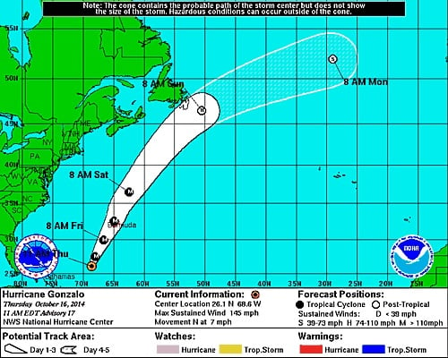
As of 11:00 a.m. Atlantic Standard Time (15:00 UTC) on Thursday, October 16, 2014, Hurricane Gonzalo’s eye was located at 26.1°N, 68.6°W, about 485 miles (780 km) SSW of Bermuda. The storm is moving north at 7 mph (11 km/h). Maximum sustained winds are close to 145 mph (230 km/h) according to the National Hurricane Center (NHC), making the storm a Category 4 Hurricane on the Saffir-Simpson wind intensity scale. The minimum central pressure is 940 mb. Hurricane-force winds extend outward up to 45 miles (75 km) from the center and tropical storm-force winds extend outward up to 150 miles (240 km).
As Gonzalo moves into cooler sea surface temperatures and slightly higher wind shear over the next 24 hours, it is expected to weaken slowly and turn towards the north-northeast while increasing its forward speed. However, it is still expected to be a Category 3 storm when it passes very close to Bermuda on Friday. Gonzalo is the strongest hurricane to occur in the Atlantic since Ophelia in 2011. It is the first major event to impact Bermuda since Hurricane Fabian in 2003.

Hurricane Gonzalo’s Potential Track Area as of 11:00 a.m. AST October 16, 2014 (Source: NHC)
Reported and Expected Impacts
Gonzalo has already claimed one life in St. Maarten and injured over 10 people in Antigua, while causing power outages, water shortages, and structural damage in several Caribbean islands, particularly St. Maarten and St. Martin, Antigua, and the Leeward Islands. Winds reaching 88 mph (142 km/h) damaged a luxury hotel on the west coast of Antigua, blew off roof coverings, and caused severe damage to the island’s farms. Several ships from Carnival, Disney, and Royal Caribbean cruise lines have canceled or changed itineraries due to the storm.
Gonzalo is expected to pose a significant threat to Bermuda beginning late Thursday evening into Friday morning, with hurricane conditions arriving on Friday. L.F. Wade International Airport is scheduled to remain closed between Thursday night and Saturday, and airlines have scheduled extra flights to help visitors leave in advance of the storm. The island is still recovering from Tropical Storm Fay, which struck on Sunday, and prices for contractors are already rising in anticipation of Gonzalo. Fay took out power to nearly all of Bermuda and power still has not been restored everywhere. Fay also downed trees, branches, and coconuts, increasing the threat from flying debris due to Gonzalo’s winds.
Dangerous storm surges are expected in Bermuda along with severe winds. Note that winds at elevated locations and on the windward sides of hills can be accelerated significantly. Additionally, Gonzalo is expected to bring 3 to 6 inches (76 to 152 mm) of rain over Bermuda. Residents are pulling boats in from dockyards and boarding up businesses and homes, while stocking up on food and supplies. Store shelves are reportedly empty.
High surf conditions and rip currents are expected to reach portions of the Virgin Islands, the northern coasts of Puerto Rico and the Dominican Republic, parts of the Bahamas, much of the east coast of the United States, and Bermuda today.
Exposure at Risk
Bermuda's building code is extremely strict and well enforced. Homes in Bermuda are typically one or two stories high and constructed of “Bermuda Stone,” a locally quarried limestone, or of concrete blocks. Roofs are commonly made of limestone slate tiles cemented together. Commercial buildings, typically of reinforced concrete construction, rarely exceed six stories. Wood frame structures, which are more vulnerable to wind damage, are not common on the island. In both residential and commercial buildings, window openings are generally small and window shutters are common. Unprotected doors and windows can increase a building’s vulnerability to damage from flying debris.
These features make Bermuda’s building stock quite resistant to winds, and homes are designed to withstand sustained winds of 110 mph (equivalent to a Category 2 hurricane) and gusts of up to 150 mph. Hurricane Gonzalo will put to test Bermuda’s building code with a close bypass as a Category 3 hurricane.
The AIR tropical cyclone team will continue to monitor Hurricane Gonzalo, as well as a developing storm in the Central Pacific, Tropical Storm Ana, which has the potential to affect Hawaii this weekend. Updates will be provided as warranted by events.