Hurricane Gonzalo
Status: Closed
Pre-Landfall 3 | Summary
Posting Date: October 17, 2014, 1:00:00 PM
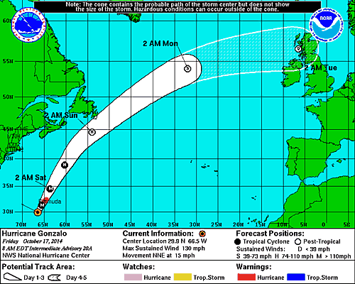
Although Hurricane Gonzalo weakened slightly overnight, it is still a powerful Category 3 storm packing maximum sustained winds of 125 mph. Its hurricane-force wind field has expanded to 60 miles in diameter. The center of the National Hurricane Center’s cone of uncertainty places Gonzalo just 10 miles west of Bermuda at its closest pass by the island, which is anticipated to be on the right-hand side of the storm and therefore bear the brunt of Gonzalo’s impacts. At its closest pass, Gonzalo is expected to still be a Category 3 hurricane.
Tropical storm conditions began on the island this morning, and hurricane conditions—including dangerous storm surges, hurricane-force winds, rainfall between 2 and 4 inches, and localized flooding—are expected to begin tonight.
Gonzalo is taking a similar path with similar intensity to Hurricane Fabian, which caused between USD 250 and USD 300 million of damage on the island (in 2003 dollars). Fabian, which struck Bermuda in 2003 as a Category 3 hurricane but impacted no other land mass, has since had its name retired.
Reported and Expected Impacts
Schools across the island are closed today. L.F. Wade International Airport has remained closed since yesterday and is not expected to reopen until tomorrow at the earliest. Bus and ferry services are shut down, and shelters have opened.
Gonzalo will be the second storm to impact Bermuda in a week, following close behind Tropical Storm Fay, which knocked out the power to nearly everyone on the island. There is still debris scattered across the island that was left behind by Fay—consisting mainly of trees, tree limbs, and coconuts—and power has not yet been completely restored. There are concerns that Gonzalo will cause this debris to become airborne as it passes by the island tonight, causing more damage than would heavy winds alone. Unprotected windows and sliding glass doors on balconies will be very vulnerable to flying debris. Once these openings are compromised, structural damage may occur, which may result in damage to contents and interior finishes.
It is likely that Gonzalo will cause additional damage to trees, electricity poles, and communications towers. Damage to roofs is also expected.
After impacting Bermuda, Gonzalo is forecast to head toward Newfoundland as an extratropical cyclone, where power outages, flooding, downed trees, and rough surf could be experienced late Saturday.
AIR has personnel on the ground in Bermuda and will conduct a survey of the damage there as soon as is feasible. AIR is running the AIR Tropical Cyclone Model for the Caribbean, which includes Bermuda, to determine whether the damage resulting from Gonzalo warrants a full loss posting.
Hurricane Gonzalo's 4-day forecast track (Source: NHC)