Hurricane Iselle
Status: Closed
| Type of posting | Posting date(EST): | Summary | Downloads |
|---|---|---|---|
| Landfall | 8/8/2014 1:30:00 PM |
|
|
| Pre-Landfall 2 | 8/7/2014 1:23:00 PM |
|
|
| Pre-Landfall 1 | 8/6/2014 12:30:00 PM |
|
Pre-Landfall 1 | Summary
Posting Date: August 6, 2014, 12:30:00 PM
Hurricane Iselle, which has been tracking toward Hawaii since last week, is projected to make landfall on the Island of Hawaii (the Big Island) Thursday night local time. At one time a Category 4 storm, Iselle (pronounced ee-SELL) has weakened to a Category 1 hurricane and is expected to further weaken to a tropical storm by landfall. Hurricane Julio, tracking behind Iselle and slightly to the north, is forecast to pass near Hawaii on Sunday, also as a tropical storm.

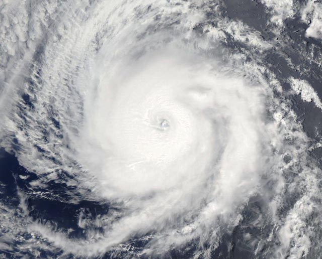
Satellite image of Hurricane Iselle on August 3 as a Category 3 storm (Source: NASA)
Meteorological Summary and Forecast
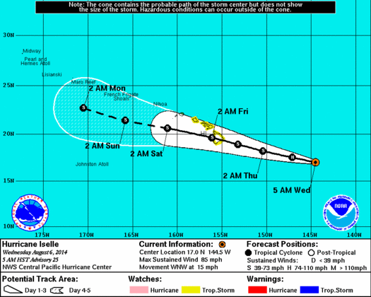
Hurricane Iselle, which made its way into the Central Pacific midday yesterday, is the fourth hurricane of the Eastern Pacific season. Iselle has begun to weaken due to elevated wind shear and dry air being entrained into the storm and is expected to be a tropical storm at the time of impact with the islands. If the central track of the Central Pacific Hurricane Center (CPHC) cone is realized, Iselle will be the first direct hit on a Hawaiian island since 1992, when Hurricane Iniki struck Kauai Island. In addition, it would be the first tropical storm to directly hit the Big Island—the Island of Hawaii—since 1958. Last year’s Tropical Storm Flossie stayed just north of the island.

Forecast track for Hurricane Iselle (Source: CPHC)
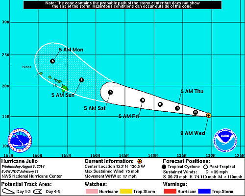
Hurricane Julio, the fifth hurricane of the Eastern Pacific season, is following a very similar track to Iselle, although slightly north. Julio will be near Hawaii on Sunday, likely weakened to a tropical storm. However, Julio may pass over an area of warmer sea-surface temperatures, leading to slower weakening on approach to Hawaii.

Forecast track for Hurricane Julio (Source: CPHC)
Expected Impacts
The main hazards facing Hawaii are tropical storm force winds on the Big Island, especially in Hilo, the largest city on the island, which sits right at the center of Iselle’s CPHC cone of uncertainty. Large waves are also a hazard along the coast and may lead to erosion. In addition, heavy rains are expected, which could lead to mudslides and flash floods.
School closures already have been announced, and residents and the many visitors to the Hawaiian islands have been warned to prepare for Iselle. Other impacts could include sea surges and flooding, as well as power outages, airport departure delays, cancellations of cruise ship dockings, and curtailment of charter boat and private boat activities. Also, trails, campsites, and some roads in mountainous parts of the islands may be closed.
Exposure at Risk
With wind speeds down to tropical storm strength at landfall, the primary exposures at risk from Iselle will be residential structures. Most single-family and duplex homes in Hawaii are of wood frame construction, with about 40% of these being single-wall wood frame construction. Generally load-bearing walls in these buildings are made of thin plywood boards and thus are quite susceptible to wind damage. (Buildings of this construction did not fare well when Category 4 Hurricane Iniki struck.) With tropical-storm-force winds, significant damage is not expected to residential structures built to code. Older structures, and those not built to newer building standards, may see some impact to roofing cover or poorly attached siding from tropical-storm-force winds. As with any storm, debris from failed roof covers or other sources could be mobilized to generate further damage.
The AIR tropical cyclone team is carefully tracking both Iselle and Julio and will provide updates as warranted.