Hurricane Odile
Status: Closed
| Type of posting | Posting date(EST): | Summary | Downloads |
|---|---|---|---|
| Post Landfall 2 | 9/22/2014 6:00:00 AM |
|
|
| Post Landfall 1 | 9/15/2014 12:30:00 PM |
|
Post Landfall 1 | Summary
Posting Date: September 15, 2014, 12:30:00 PM
At about 9:45 p.m. Sunday (local time) Hurricane Odile made landfall near the Mexican resort town of Cabo San Lucas, located on Mexico’s southern Baja California peninsula, with torrential downpours and powerful winds. The landfall came as something of a surprise to forecasters at the National Hurricane Center, as earlier forecasts on Sunday had the storm staying further west, off the coast, and moving at a slower speed.
The region is home to megaresorts, tiny fishing communities, and low-lying neighborhoods of non-engineered homes. While Odile had reached Category 4 strength on the Saffir-Simpson Scale on Sunday, the hurricane made landfall as a Category 3 storm with estimated wind speeds of 127 mph. An estimated six months’ worth of rain fell on Cabo San Lucas in just one hour. Odile has since been downgraded and is currently a Category 2 storm. Baja California and coastal regions of Sinaloa and Sonora could see heavy rains and strong winds into Tuesday.
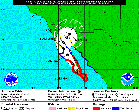
Forecast Track and Intensity
Forecasters predicted a dangerous storm surge with large waves as well as drenching rains capable of causing landslides and flash floods. The U.S. National Hurricane Center (NHC) also warned of possible coastal flooding, with a storm surge between 6 and 10 feet, and rainfall of 5 to 10 inches, with isolated amounts up to 15 inches. Hurricane-force winds extend outward from the hurricane’s center up to 50 miles and tropical storm-force winds as far as 185 miles.
Odile is expected to move northwest into southern and central Baja peninsula through Tuesday. Coastal regions of Sinaloa and Sonora will also experience locally heavy rainfall into Tuesday. During the afternoon hours over the next several days, heavy thunderstorms will develop along the Sierra Madre Occidental mountain range. There is also a chance the storm could track into the Gulf of California, also known as the Sea of Cortez, and as a precaution authorities there are on high alert. Odile should begin to weaken later today as it picks up more stable air and cooler water, according to the NHC. The U.S. Southwest has a good chance of getting a round of flooding rain as the moisture from Odile heads north.
Warnings and Reported Damage
A hurricane warning was in effect from Punta Abreojos to Loreto. Mexican authorities declared a maximum alert for areas in or near Odile's path, and ports in Baja California were ordered closed. Luis Felipe Puente, national coordinator for Mexico's civil protection agency, said 164 shelters had been prepared for as many as 30,000 people in Baja California Sur. Some 800 marines were on standby, and officials readied heavy equipment to help out in areas where mudslides could occur. Police with megaphones walked through vulnerable areas in Cabo San Lucas urging people to evacuate. Some tourists camped out at the Los Cabos International Airport hoping to get out before the storm, but the facility shut down all air operations late in the afternoon; at least 22 airline flights were canceled. Local residents and tourists should expect extended power outages along with loss of basic services.
Exposure at Risk
Insured residential buildings in the region are predominantly of masonry and concrete construction, but it is estimated that each year up to 50% of new homes are constructed without a building permit. Homes not built to any wind design standard are likely to see damage beyond that to roofing shingles or cladding, with significant structural damage possible. The commercial building stock in Mexico is heterogeneous, varying from poorly constructed low-rise masonry structures to well-maintained steel buildings. Well-constructed buildings are not likely to see significant damage, although damage to roof coverings and cladding may occur where they were poorly installed or have seen little maintenance over time. At Category 2 or 3 wind speeds, unprotected building openings (i.e., windows or sliding doors) may be at significant risk of debris impact. Damage to windows or doors of both residential and commercial structures not only allows for wind damage to further increase, but it also allows for rain water infiltration, which can damage insured contents. Flash flooding from sustained rainfall is also likely, bringing damage to unprotected building contents.
AIR’s tropical cyclone team continues to monitor Hurricane Odile and its impact and will provide additional information as events warrant.

Five-day forecast track for Hurricane Odile (Source: NHC)