Hurricane Odile
Status: Closed
| Type of posting | Posting date(EST): | Summary | Downloads |
|---|---|---|---|
| Post Landfall 2 | 9/22/2014 6:00:00 AM |
|
|
| Post Landfall 1 | 9/15/2014 12:30:00 PM |
|
Post Landfall 2 | Summary
Posting Date: September 22, 2014, 6:00:00 AM
Current Conditions
As of Monday, September 22, at 9:00 AM EST (13:00 UTC) Hurricane Odile has dissipated over the southwestern U.S. On Friday and over the weekend, the storm produced light to moderate rain, with pockets of heavy rain, across southern New Mexico and western and central Texas as it moved slowly eastward. Rainfall totals reached 2-4 inches in many areas but some had much higher amounts including Gail, Texas, which received over 15 inches.
Odile’s Passage across Mexico
Odile made landfall near Cabo San Lucas, Mexico, on Sunday, September 14, at 9:45 PM (local time) as a Category 3 hurricane with maximum sustained winds of 125 mph according to the National Hurricane Center. From there, Odile moved directly up the center of Baja California, bringing strong winds and heavy rain. The storm weakened as it moved northward over land; however, the weakening slowed as it curved towards the northeast and moved over the Gulf of California. Rainfall totals along the track were in the range of 6-12 inches, with some localities receiving heavier amounts.
At around 11 AM Wednesday, the storm made its second and final landfall as a marginal tropical storm in Sonora, Mexico, located in the northwestern region of Mexico’s mainland. From there, the storm continued into the United States weakening rapidly but producing heavy rainfall in the extreme southern regions of Arizona, southern New Mexico, and western and central Texas.
Reported Damage and Disruption in Mexico
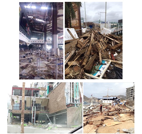
Damage in Baja was widespread and severe. Reports of the heaviest damage have been from Cabo San Lucas, Mexico, with significant losses reported at the airport and several resorts. At least 135 people were injured while the hurricane collapsed hotels, flattened homes, and left shattered glass, debris, smashed cars, and fallen trees and power lines along flooded streets. About 30,000 tourists were evacuated to shelters from several luxury resorts. One of the shelters collapsed causing the tourists to take refuge on the stairs of a service area.
The Cabo San Lucas, La Paz, San Jose del Cabo, and Loreto airports were closed Monday although commercial and military planes flew foreign tourists out of the area. A terminal roof at Los Cabos Airport was detached and the ceiling partially collapsed; about 44 flights were cancelled. At La Paz airport, damage was limited to terminal interiors and operations are returning to normal.
Power was out for about 90% of Baja’s population as the storm damaged power generation facilities and blew over transmission lines. Potable water was unavailable in several towns and some convenience stores were looted by people seeking food, bottled water, batteries, and other supplies. The CFE electric utility estimates that 95% of power outages will be restored by Friday. Communication lines were also blown down or hit by toppled trees.

(clockwise from top left) Cabo San Lucas Airport (@jimmyverduzco via Twitter); Cabo San Lucas (Sarah S. McKinney via Twitter); Debris outside a Los Cabos hotel (Whitney Roe Wells via Twitter); Hotel in San José del Cabo (Hermelinda Vargas via Twitter)
Exposure in the Affected Areas of Mexico
Insured residential buildings in the region are predominantly of masonry and concrete construction, but it is estimated that each year up to 50% of new homes are constructed without a building permit. Homes not built to any wind design standard are likely to see damage beyond that to roofing shingles or cladding, with significant structural damage possible.
The commercial building stock in Mexico is heterogeneous, varying from poorly constructed low-rise masonry structures to well-maintained steel buildings. At Category 2 or 3 wind speeds, unprotected building openings (i.e., windows or sliding doors) may be at significant risk of debris impact. Damage to windows or doors of both residential and commercial structures not only allows for wind damage to further increase, but it also allows for rain water infiltration, which can damage insured contents. Flash flooding in these areas will cause further damage.
Odile’s Impact in the Southwestern U.S.
After tracking into the southwestern U.S. Friday, a considerably weakened Odile continued to produce gusty winds and heavy rain across a wide region spanning from the southern areas of Arizona and New Mexico into western and central Texas. Arizona was largely spared as the storm headed for central Texas, into a region that is currently being affected by flooding from other storm systems.
By 9:00 AM EST Monday, September 22, Gail, Texas, located in Borden County, had received 15.26 inches of rain. All of Borden County was under a flash flood warning on Saturday, September 20. Some visitors in recreational areas could not leave due to road closures, and infrastructure was disrupted due to power outages. Fluvanna, Texas, located in Scurry County, was also inundated with 9.62 inches of rain and under a flash flood watch. Guadaloupe Mountains National Park received 8.13 inches. Other heavy totals in Texas include 5.53 inches at Slaton, and over 4 inches at several communities including Sundown and Brownfield. El Paso had reported 3.11 inches of rain on Friday, with 2.68 inches at El Paso International Airport, while 1.17 inches were reported at Lubbock International Airport. Heavy rain was reported in southern New Mexico; as of Friday, 4.13 inches had fallen at Mogollon, 3.63 inches at Glenwood, and 3.5 inches at Chaparral. The Deming Municipal Airport reported 2.98 inches and the Las Cruces International Airport received 2.1 inches. In Arizona, 3.78 inches were reported on Friday at Ephraim Wash Station and 3.3 inches are reported at Douglas. Friday reports also indicate 3.05 inches at Bisbee-Douglas International Airport, and 3.01 inches at Nogales International Airport.