Tropical Cyclone Hudhud
Status: Closed
| Type of posting | Posting date(EST): | Summary | Downloads |
|---|---|---|---|
| Post Landfall 2 | 10/20/2014 1:00:00 PM |
|
|
| Post Landfall 1 | 10/13/2014 1:00:00 PM |
|
|
| Landfall | 10/12/2014 8:00:00 AM |
|
Landfall | Summary
Posting Date: October 12, 2014, 8:00:00 AM
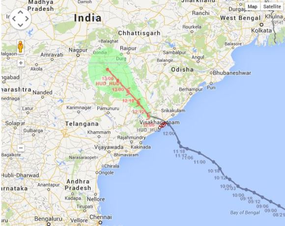
Cyclone Hudhud, which has been tracking northwest over the Bay of Bengal for several days, has made landfall on October 12 between 12:00 IST and 13:00 IST (6:30 UTC and 7:30 UTC) near the city of Visakhapatnam in the eastern state of Andhra Pradesh. Visakhapatnam is the largest city in Andhra Pradesh and the third largest city on India's east coast. Estimated population in the greater metropolitan area exceeds 2 million as of 2011.
Current Situation
According to the latest bulletin from the India Meteorological Department (IMD), Very Severe Cyclonic Storm Hudhud as of 14:30 IST (9:00 UTC) was located at 17.8°N and 83.0°E with maximum sustained winds of 75 knots and gusts up to 85 knots. Hudhud will continue to move inland toward the northwest as it weakens gradually.
Winds are forecasted to weaken to 54-60 knots (gusts to 65 knots) over the next 3 hours and eventually weaken to 43-49 knots over the next 6 hours for the East Godavari, Visakhapatnam, Vizianagaram and Srikakulam districts of north Andhra Pradesh. The districts of Koraput, Malkangiri, Nabarangpur and Rayagada can expect winds of 43-49 knots and gusts to 54 knots for the next 6 hours, eventually weakening to 27 to 32 knots for the following 12 hours. The districts of West Godavari and Krishna of Andhra Pradesh, Ganjam & Gajapati districts of Odisha, south Chattisgarh and adjoining districts of north Telangana can expect sustained winds of 30-35 knots and gusts up to 40 knots over the next 12 hours.
In the next 24 hours, rainfall is expected to be extremely heavy, with some regions possibly receiving between 6.5 cm and even more than 24.5 cm. Areas of concern are west and east Godavari, Visakhapatnam, Vijayanagaram and Srikakulam districts of north Andhra Pradesh and Ganjam, Gajapati, Koraput, Rayagada, Nabarangpur, Malkangiri, Kalahandi, Phulbani districts of south Odisha.
Storm surge is expected for the next 3 hours in amounts of 0.5 to 1.0 meters above astronomical tide for the areas of Visakhapatnam, Vijayanagaram and Srikakulam districts of north coastal Andhra Pradesh.
Reported and Expected Impacts
In advance of the storm’s arrival, India’s South Central Railway announced the cancellation or diversion of trains in and out of Visakhapatnam, and all flights were cancelled. Some 400,000 people were evacuated from the coast of Andhra Pradesh and neighboring Odisha (Orissa). A year ago, Cyclone Phailin—the strongest storm to strike India in more than a decade—struck the coast of Odisha, north of Hudhud’s landfall. In advance of that storm's arrival, India conducted its largest storm evacuation ever—more than 900,000—which has been credited for keeping the death toll to just 25. Hudhud is not as strong as Phailin, but it is making landfall in a more densely populated stretch of the coast.
Photos and video footage from Visakhapatnam show downed trees and electrical poles, and significant amounts of debris in the streets. Although winds will begin to weaken as the storm moves inland, the torrential rainfall associated with this storm may result in inland flooding as rivers swell to dangerous levels.
Exposure at Risk
Historically, the dominant construction type in India has been unreinforced masonry. This construction is typically made from various traditional materials, including adobe, rubble stone, or burnt brick. Unreinforced masonry is still pervasive throughout rural India in low- and mid-rise residential and commercial structures.
Increasingly, however, modern urban buildings in India are employing more durable construction types, such as confined masonry and reinforced concrete. Moreover, these buildings are incorporating advanced features in their design and are subject to better construction practices and stricter code enforcement. This is particularly true of new high-rise buildings, which are generally made of reinforced concrete.
Extensive damage is expected to poorly constructed homes, including to mud and thatched roof structures common in fishing villages along India’s eastern coast. Storm surge—possibly up to two meters—is also a major concern in these low-lying locations. While these structures are certainly uninsured, personal property is not adequately insured even in urban areas. Crops are likewise largely uninsured. In contrast, industrial risks, including energy, oil, and gas plants in the affected region, are well insured against natural disasters.
The AIR tropical cyclone team continues to monitor Cyclone Hudhud. A second NewsALERT is scheduled for tomorrow, after the storm has made its way inland and the rate of dissipation is better known.
Track of Cyclone Hudhud (Source: India Meteorological Department)