Typhoon Rammasun
Status: Closed
Landfall | Summary
Posting Date: July 16, 2014, 7:00:00 AM
Typhoon Rammasun Makes Landfall in Philippines, Tracks Toward Manila
With sustained winds of 157 km/h (98 mph), Typhoon Rammasun made landfall in the Philippine province of Sorsogon July 15, late afternoon local time, and headed toward Manila. Although smaller and much less intense than deadly and highly destructive Super Typhoon Haiyan—which devastated parts of the Philippines in November 2013—Typhoon Rammasun nonetheless prompted sizable evacuations and resulted in some disruption of transportation, as well as school and office closings. Widespread damage is not expected, but some areas could experience storm surge flooding, flash flooding, and/or mudslides, as well as wind damage.

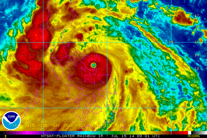
Infrared satellite image of Rammasun near the time of landfall, 8-9 UTC, July 15, 2014. (Source: NOAA)
Forecast to pass about 50 km (30 miles) from Manila, Typhoon Rammasun will bring heavy rains and high winds to the central Philippines as it travels west-northwest toward the South China Sea. Depending on Rammasun’s structure as it leaves land, the storm could reintensify over the water, prior to threatening southern China and Vietnam.
Meteorological Summary and Forecast
Typhoon Rammasun (also known as Glenda in the Philippines) made landfall in the Philippine province of Sorsogon between 8 and 9 UTC July 15 as a strong typhoon with a central pressure of 945 mb and maximum 10-minute sustained winds of 157 km/h (~98 mph), according to the Japan Meteorological Agency (JMA). As a precaution, the national weather agency in the Philippines, PAGASA, issued a number-three level public storm warning signal for wind gusts of up to 185 km/h (115 mph). Rammasun is not a significant threat to areas affected by Typhoon Haiyan (2013).
Rammasun rapidly intensified in the 12-hour period prior to landfall, with its central pressure decreasing from 975 to 945 mb and maximum sustained wind speeds increasing from 120 to 157 km/h (75 to 98 mph), according to JMA intensity estimates. At landfall, Rammasun featured the well-defined eye and symmetrical eyewall evident in the satellite image, indicative of a strong typhoon. As of 12 UTC on July 15, Rammasun was located at latitude 13.4° N and longitude 123.4° E, and is moving to the west-northwest.
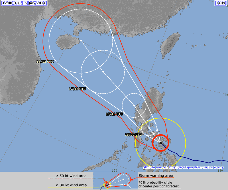
The JMA forecast indicates continued motion to the west-northwest along the southern periphery of the subtropical ridge. On this track Rammasun will traverse southern Luzon Island, passing about 50 km (30 miles) to the northeast of the capital of Manila. Passage over land will result in considerable weakening, with the present JMA forecast indicating a central pressure of 975 mb and maximum sustained wind speeds of 120 km/h (75 mph) as Rammasun exits the Philippines.

Track forecast of Typhoon Rammasun as of UTC 1200, July 15, 2014. (Source: JMA)
Upon reemerging in the South China Sea, conditions appear favorable for modest restrengthening, with warm sea surface temperatures and favorable upper-level conditions. The JMA forecast from 12 UTC July 15 indicates modest restrengthening over the South China Sea, with the central pressure decreasing to 970 mb and maximum sustained wind speeds increasing to 130 km/h (~80 mph), as Rammasun approaches Hainan. The Joint Typhoon Warning Center forecast indicates more significant intensification in the South China Sea, with maximum wind speeds approaching 194 km/h (~120 mph). The degree of reintensification over the South China Sea will be highly dependent on the structure that Rammasun is able to maintain as it traverses the Philippines, and therefore is highly uncertain at this time.
Exposure at Risk
With the expected wind speed and track, typhoon Rammasun will impact a region of the Philippines that is largely rural and agricultural, although some cities are in the path of the storm. Given that the region is generally less urbanized and less accustomed to typhoons, construction types and standards are lower than those in the northern islands. While reinforced masonry structures are typical, light materials—such as wood frames with galvanized iron and aluminum roofs—are frequently used for residential buildings in these rural areas, making them more vulnerable when compared with those in neighboring Hong Kong, or Taiwan. Homes constructed of light material may experience moderate- to high-level cladding and roofing damage, involving loss of roof covering, as well as the removal of porch coverings and awnings; some of these homes could even be destroyed. In extreme instances, some structurally deficient buildings could even collapse.
Well-constructed engineered buildings could have some damage to roofing and siding, especially from windward corners, rakes, and eaves. Some apartment building and shopping center roof coverings could experience moderate levels of damage, and wall siding may also experience some moderate levels of wind damage. Structural damage is not expected for engineered structures.
Expected Impacts
Some evacuations were ordered as Typhoon Rammasun approached the Philippines; because of the risk of storm surge flooding, flash floods, and mudslides, other evacuations also could occur as the storm crosses the country. Other precautions taken prior to landfall include shuttering some government offices and schools, closing the financial markets, and suspending some commuter rail service.
Although Typhoon Rammasun made landfall in a largely agricultural region, a sizable swath of the population will be affected as it moves across the country toward Manila and other population centers. Expected impacts include loss of electrical power; short-term suspension of ferry service, land transport, and airport operations; and business and school closings. Storm debris—such as downed trees and roofs torn off buildings—could exacerbate some of the storm impacts.
Typhoon and flood damage are usually covered together in the Philippines and are given under separate fire policies with named perils extensions. Take-up rate varies by region. Typhoon Rammasun will affect some densely populated and urban areas, including Manila, where the take-up rate for residential lines would be around 5-10% and 25-30% for commercial/industrial. Still, given that insurance penetration in this area is around 10% - 20%, insured losses are not expected to be significant as a result of this typhoon.
The AIR tropical cyclone team will continue to closely monitor the progress of Typhoon Rammasun and will provide updates as warranted.