Typhoon Rammasun
Status: Closed
Post Landfall 2 | Summary
Posting Date: July 17, 2014, 12:30:00 PM
Typhoon Rammasun Poised to Strike Hainan Province in China
Having brought flooding and damaging winds to the Philippines, a strengthening Typhoon Rammasun is set to make landfall between 6 and 12 UTC on July 18, 2014, as a strong tropical cyclone. According to the July 17 12:50 UTC advisory from the Japan Meteorological Agency (JMA), the storm is currently located approximately 530 km (~330 mi) south of Hong Kong in the South China Sea and is moving to the northwest at approximately 15 km/h (9 mi/h). Rammasun is packing maximum sustained wind speeds of 148 km/h (92 mi/h) and has a minimum central pressure of 955 mb.
Meteorological Summary and Forecast
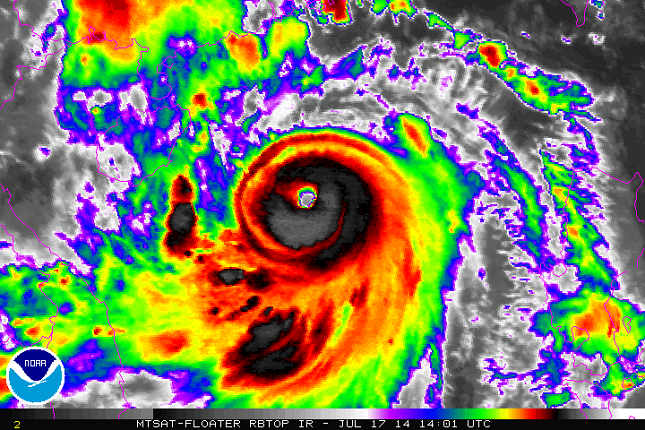
Animated satellite imagery indicates that Rammasun has been strengthening, as a well-defined eye and eyewall are now evident (see satellite image). Intensification is expected to continue in favorable environmental conditions that include low wind shear and very warm sea surface temperatures.

Infrared satellite image of Rammasun over the South China Sea, at 14:01 UTC July 17. (Source: NOAA)
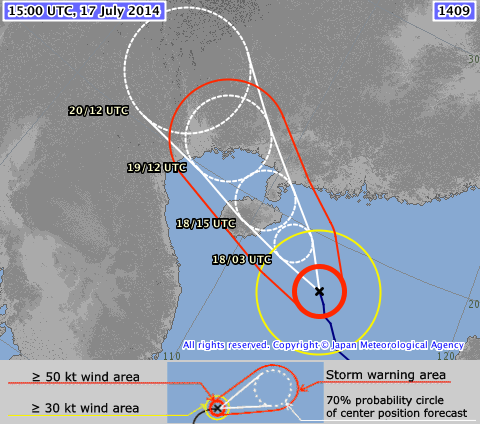
The storm is forecast to continue moving to the northwest prior to making landfall in the northeast tip of Hainan. The storm’s central pressure is expected to fall to 950 mb as maximum sustained wind speeds increase to 158 km/h (98 mi/h). After impacting Hainan, Rammasun is forecast to make its next and final landfall near the China-Vietnam border.

Forecast track of Rammasun (Source: JMA)
Reported Impacts
Typhoon Rammasun made landfall late Tuesday—near Legazpi City on the Philippine’s east coast, killing 38 people and forcing over 400,000 residents to evacuate to higher ground. The storm’s powerful winds toppled trees and ripped off roofs. Downed power lines left residents in 11 provinces without power, and 7,000 homes were completely destroyed and almost 20,000 more were damaged. Infrastructure also suffered, as 15 roads and 4 bridges are impassable. Fears of residual effects such as flooding and landslides remain in the Philippines.
In preparation for Typhoon Rammasun’s impact in China, trains destined for Hainan Province are being re-routed to Guangzhou on Friday and Saturday, and operation of Hainan's high-speed railway, which connects the provincial capital of Haikou and Sanya City, has been suspended. Ships are also not serving Weizhou Island, as China’s National Marine Environmental Forecasting Center issued the highest possible warning— a red alert. The country's top flood-control and drought-relief authority has launched an emergency response effort that includes sending eight working teams to assist local authorities in Hainan.
Houses in coastal regions of southern China are commonly confined masonry or reinforced concrete with clay tile roofs, which perform reasonably well in the face of typhoon winds. Insurance take-up for typhoon coverage is low in China, particularly for residential risks. When there is coverage, wind and flood generally are covered together in the same policy. As is often the case with China typhoons, flooding is a major concern; with much of the population located near waterways and along the coast, many homes and businesses are at risk.
The AIR tropical cyclone team will continue to monitor Typhoon Rammasun and will provide updates as necessary.